

Feb 14: Winter Storm Update
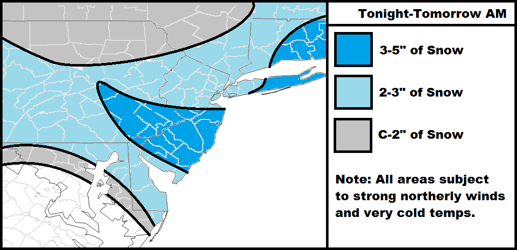
Here’s my final call for tonight through tomorrow. Everything looks a little bit south which is why the heaviest snowfall has been shifted to CNJ and parts of SNJ. While all of NJ should see at least light snowfall, I think coastal CNJ and SNJ will end up with a little bit more. Regardless, it’s now-casting time. Some preliminary snow showers have already drifted through but the coastal hasn’t even formed yet. I expect snowfall to begin picking up from west to east between 8 and 10pm and last through sunrise tomorrow morning.
As I’ve been saying with this system, winds and cold temperatures have the headline, not the minor to significant snowfall that’s possible. Please watch out for downed tree branches, power lines, or any other hazards that accompany high winds. Please make sure all animals that need to come inside are inside as temperatures will be diving hard behind the Arctic front.
In English: Light to moderate snowfall is possible anytime time from now through tomorrow morning. The map above best represents my thoughts on totals. It will be very cold and windy so stay warm and be safe! JC
Jonathan Carr (JC) is the founder and sole operator of Weather NJ, New Jersey’s largest independent weather reporting agency. Since 2010, Jonathan has provided weather safety and forecasting services for New Jersey and immediate surrounding areas through the web, social media, and app spaces. Originally branded as Severe NJ Weather (before 2014), Weather NJ is proud to bring you accurate and responsible discussions ahead of high-stakes weather scenarios that impact the garden state. All Weather. All New Jersey.™


LOCAL FORECAST | INTERACTIVE RADAR | LATEST NJ WEATHER ALERTS | WEDDING FORECAST| PRIVACY POLICY
© Copyright 2024 Weather NJ LLC. All Rights Reserved.
Some information that can be found on our website is provided by a private weather station and is not an officially recognized station for weather reporting. Though we always strive to achieve accurate reporting for our own use, it is important that you do NOT depend on the data provided here for any purpose.
