

Feb 18: Wednesday Travel Safety Concerns Grow

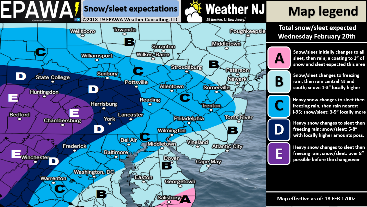
Click here to view full resolution snow/sleet map!
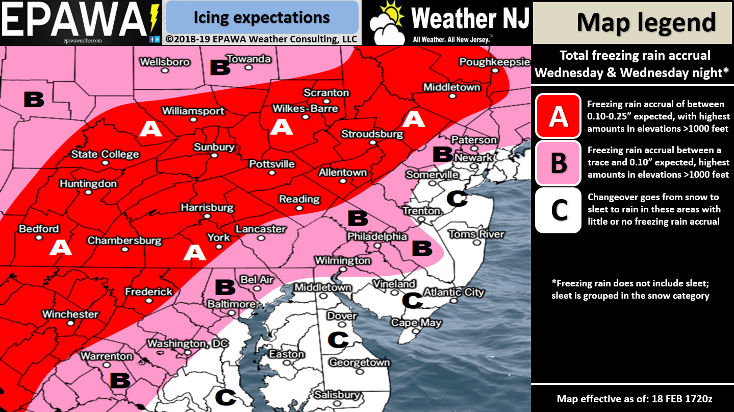
Click here to view full resolution freezing rain map!
Discussion: This Wednesday’s winter storm will not be a major snow event. It could however present travel safety hazards for Wednesday PM travel. The most likely outcome is an initial burst of snow for most of NJ followed by a transition to either sleet and/or freezing rain before ultimately going over to plain rain for most. If you use I-195 as a divider between NNJ and SNJ then NNJ has a better chance to see more ice during the transition. SNJ could still see some ice but would likely change from snow/sleet over to rain rather quickly especially closer to the coast/SENJ.
There’s nothing spectacular about the upper-levels with this system. We do have a strong jet streak at 250mb, which could enhance some pressure drops in the lower-levels, but the 500mb pattern looks unfavorable for snow storm development. Instead we have SW upper-level flow that will guide and push this system’s warmth and moisture to the NE into an area of high pressure. The high is very strong. Currently it is about 1046mb and dropping out of W Canada into the NW US. This high will slowly track across the N US, over our region and ultimately out to sea. The timing of the high and low just happen to be close enough to cause a period of convergent wintry precipitation for NJ. The high will hold the surface layers cold while the warm air advects in at the low-mid levels. The front-side of this high should keep us colder with NJ flow from now until the disturbance arrives Wednesday morning. That should make Tuesday (tomorrow) a cold dry day.
Traditionally this kind of setup produces snow accumulations quickly wiped out by rainfall. However in this case we feel the front-end wintry thump could possibly be more significant in the form of snow/sleet for NNJ/CNJ. By the time the ending-rainfall occurs it might be too late at the surface with wintry damage done. This will all rely on how strong the frontogenesis is across the region. Frontogenesis is the process by which strong lifting (frontogenic forcing) produces heavy rates of precipitation. These heavy rates of precipitation then cool the column and bring cold air to the surface allowing more of a chance for stickage. The frontogenesis will have to be nowcasted and will be the ticket to this over-performing on the front-side wintry end. We won’t have a good grasp on that until early Wednesday morning when precipitation is approaching from the SW. Therefore for now the fronto remains a good possibility wildcard. Another aspect worth considering is that most snowfall and ice accretion should take place during peak daylight hours on Wednesday. Sun angle could therefore inhibit accumulations regardless of how much snow falls. With all this said we could see lower accumulations on road surfaces but higher accumulations on natural surfaces. These are all factors that I’ll continue to track closely and factor into the evolving forecast. At the very least however NJ should expect travel safety issues this Wednesday between late-morning and evening hours with peak wintry impact conditions close to or during PM rush hour.
In English: Gusty winds should continue tonight but should subside some by tomorrow morning. A snow-to-ice-to-rain scenario is becoming likely this Wedensday. Snow could start as early as Wednesday morning in SWNJ but should spread through the rest of NJ by Noon. Snow should then change to rain fairly quickly for SNJ/SENJ especially near the coast. Interior CNJ and NNJ however should see a delayed transition with significant sleet and/or freezing rain possible between. Snow amounts should be fairly unimpressive unless the higher-frontogenesis wildcard occurs on initial thump. We’ll be watching that and will aggressively aggregate tomorrow night if that’s where this trends last-minute. Otherwise precipitation should end by Wednesday night/early Thursday morning. By that point the lower 2/3 of NJ should be over to plain rain. NWNJ elevations however might hold onto snow/ice through the entire event. The above wintry impact maps represent our concerns for travel safety hazards. The first map is for snow and sleet. The second map is for freezing rain. The Wednesday PM rush hour could be downright nasty for NNJ/CNJ regardless of the wintry precip form (snow, sleet or freezing rain). Download the new free Weather NJ mobile app on Apple and/or Android. It’s the easiest way to never miss Weather NJ content. Our premium services go even further above and beyond at the hyperlocal level. Have a great rest of your President’s Day and please be safe! JC
Jonathan Carr (JC) is the founder and sole operator of Weather NJ, New Jersey’s largest independent weather reporting agency. Since 2010, Jonathan has provided weather safety discussion and forecasting services for New Jersey and surrounding areas through the web and social media. Originally branded as Severe NJ Weather (before 2014), Weather NJ is proud to bring you accurate and responsible forecast discussion ahead of high-stakes weather scenarios that impact this great garden state of ours. All Weather. All New Jersey.™ Be safe! JC


LOCAL FORECAST | INTERACTIVE RADAR | LATEST NJ WEATHER ALERTS | WEDDING FORECAST| PRIVACY POLICY
© Copyright 2026 Weather NJ LLC. All Rights Reserved.
Some information that can be found on our website is provided by a private weather station and is not an officially recognized station for weather reporting. Though we always strive to achieve accurate reporting for our own use, it is important that you do NOT depend on the data provided here for any purpose.
