

Feb 8: Final Call Snow Map
Live-casting begins now. Here are my final thoughts heading into tomorrow’s winter storm…
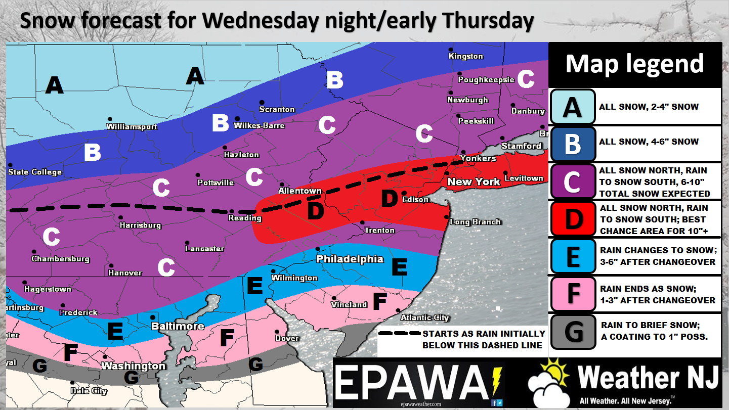
Click here to view map in full-resolution.
Discussion: Well, here we are. The best widespread snow chance of the season is knocking at our door. We have great dynamics at play:
1) Amped ridging in the W US
2) A deeper neutral-to-negative E US trough axis
3) A coastal surface low modeled to meet bombogenesis criteria with a 40N/-70W track
4) Strong expected frontogenesis/lifting at all levels
5) Annually bottomed-out sea surface temperatures
6) I probably forgot something
What we do not have is a strong blocking signature over Greenland. For this reason the system, as strong and dynamic as it should be, will be moving quicker than a typical historic east coast storm would (that typically departs OBX and retrogrades near the benchmark instead of moving through it). Instead this system will depart over Delmarva and move out to sea quicker which = less time for snow to fall regardless of how heavy it does fall. For this reason, we cannot confidently forecast a widespread 1-2 foot event at this time but we’ve outlined the best area for double-digits+ in red. This area has the best chance of Kabooming and there would be no surprise on my face if we did, in-fact, Kaboom. Snow ratios should be in the ballpark of 8:1 to 12:1 for most of New Jersey. A wetter and heavier snow.
Let’s talk wildcards: With such strong dynamics there are surprises possible in either direction. If precipitation becomes convective enough then some areas will see banding of higher snowfall rates while immediately neighboring areas see less. Such convection could also easily produce thundersnow. That would result in some areas (likely in linear segments) seeing more than expected while close-by areas see less. Also, we still don’t know if a deformation zone band will set up once the low is out to sea and N/NE winds are ripping. This would bust everyone higher than expected on totals, especially along the coast. We do not have overwhelming support for either wildcard scenario but the possibilities do need to be mentioned. Again, there would be no surprise here if such occurred. We’ll be able to detect this a few hours before it happens, if either wildcard does happen.
In English: The snow storm that we’ve been discussing on-and-off since last Friday has come into fruition. New Jersey should expect the amounts shown on our map above between 2AM and 1PM tomorrow. Remember that this will start as rain for many (below the black-dotted line on map) before changing over to snow for all areas. We’ll be able to watch the snow/rain line push from NW to SE on radar during live observations tomorrow morning. Some might see a brief period of sleet when rain changes to snow. Thundersnow is also possible in this event but that will obviously need to be live-casted. Winds should pick up once the storm becomes stronger over the ocean. The coast would likely feel this the most but winds could spread inland as well. Coastal regions up and down the Atlantic should expect negligible-to-minor coastal flooding—nothing too serious given the “more-northerly” wind profile that should quickly develop upon low ejection. Just to clarify my wildcard mentioned above…if a deform band forms and snow accumulations were to jump to double-digits+ for everyone…you will see no surprise from me. However, our map above represents the most rational and reasonable call we can possibly make at this point in time with all model guidance and live observations considered.
A few words of caution: This system is going to have major travel impacts tomorrow. Rain will likely wash away road treatments (at least partially) just prior to the changeover to wintry precipitation. This could create a thin layer of ice beneath the snow on roads and create havoc. Please use extreme caution tomorrow driving if you absolutely have to. Otherwise this seems like a school closer for at least the northern 2/3 of NJ. That’s about all I got for now. Let the live-casting begin. Everyone please be safe! JC
Jonathan Carr (JC) is the founder and sole operator of Weather NJ, New Jersey’s largest independent weather reporting agency. Since 2010, Jonathan has provided weather safety discussion and forecasting services for New Jersey and surrounding areas through the web and social media. Originally branded as Severe NJ Weather (before 2014), Weather NJ is proud to bring you accurate and responsible forecast discussion ahead of high-stakes weather scenarios that impact this great garden state of ours. All Weather. All New Jersey.™ Be safe! JC


LOCAL FORECAST | INTERACTIVE RADAR | LATEST NJ WEATHER ALERTS | WEDDING FORECAST| PRIVACY POLICY
© Copyright 2026 Weather NJ LLC. All Rights Reserved.
Some information that can be found on our website is provided by a private weather station and is not an officially recognized station for weather reporting. Though we always strive to achieve accurate reporting for our own use, it is important that you do NOT depend on the data provided here for any purpose.
