

First Winter 2014-2015 Call – Cold and Snowy!

I’ve seen enough! I’m calling for a very cold and snowy start to meteorological winter (starts on December 1)! All signs are pointing towards below average temperatures and above average snowfall to start this upcoming winter. We have a weak El Nino, full cooperation from the teleconnections, record northern hemisphere snow cover, and arctic air ready to pounce on the eastern 2/3 of the US. If you want to skip all the nerdy meteorological talk, you can scroll down to the summary in English. Otherwise, let’s go over some of the concepts I just mentioned.
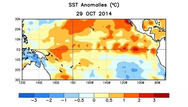
ENSO (El Nino Southern Oscillation)
El Nino and La Nina represent opposing sea surface temperature (SST) anomalies in the Pacific Ocean near the equator. Basically we’re most concerned about the sea surface temperatures to the west of northern South America. When these sea surface temperatures are above average we have an El Nino. When they are below average we have a La Nina. Furthermore, if the sea surface temperatures are only slightly above average we have a weak El Nino and same for slightly below average with a weak La Nina. Right now we have a weak El Nino developing to start this winter which typically means the Subtropical Jet Stream (STJ) will be providing plenty of moisture and energy to the region needed for big mid-Atlantic/Northeast US winter storms. The image below, courtesy of the National Weather Service Climate Prediction Center captures the developing weak El Nino:
 AO (Arctic Oscillation)
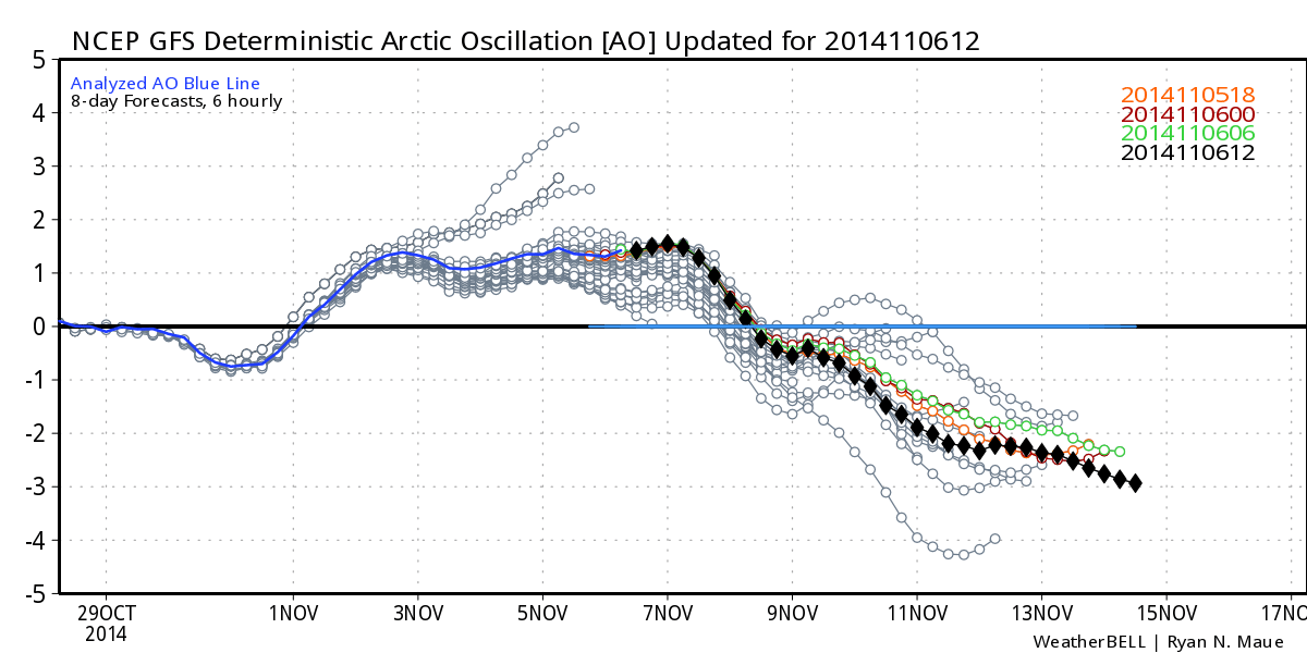

The next natural teleconnection/oscillation I’d like to mention is the AO. When the AO is positive, atmospheric pressure (geopotential heights) is lower than average in the polar region of the northern hemisphere. The westerly winds that engulf the arctic region are stronger than average which keeps the true arctic air bottled up to the north. We saw this a few winter’s ago when our region saw a warm winter with low snowfall amounts. On the contrary, when the AO is negative, atmospheric pressure (geopotential heights) is higher than average in the polar region with relaxed westerly winds across the US. This allows the true arctic air to drop southward over the US and help contribute to big mid-Atlantic/Northeast US storms. Below is the predicted AO heading into snow season:
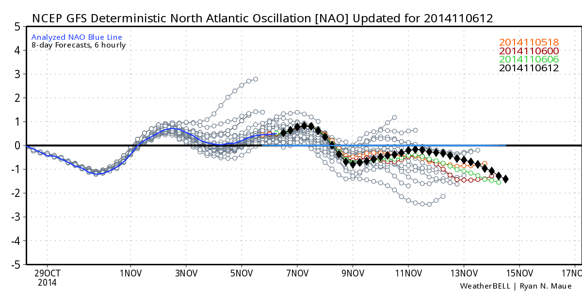
NAO (North Atlantic Oscillation)
Lets move on to North Atlantic Oscillation. This natural teleconnection/oscillation is know best for its ability to detect high-latitude blocking. There are two main systems at play—a low and a high that continuously move about the N. Atlantic Ocean. When a positive NAO sets up, it allows the jet stream(s) to be very progressive across the eastern US. By the time storms (synoptic low pressure systems) get going, they are already well to the NE of NJ having a greater impact on E. Canada. When a negative NAO sets up, it allows for troughs to deepen in the eastern US. Synoptic storms then take a slower and more meridional path up the coast. This allows storms to bomb out (bombogenesis – 20mb drop in under a 24 hour period) in time to impact the mid-Atlantic US with big snow storms. It’s important to note that NAO can be west-based (closer to US) or east-based (further offshore). A west-based -NAO is the most favorable for NJ snow. Below is the predicted NAO heading into snow season:
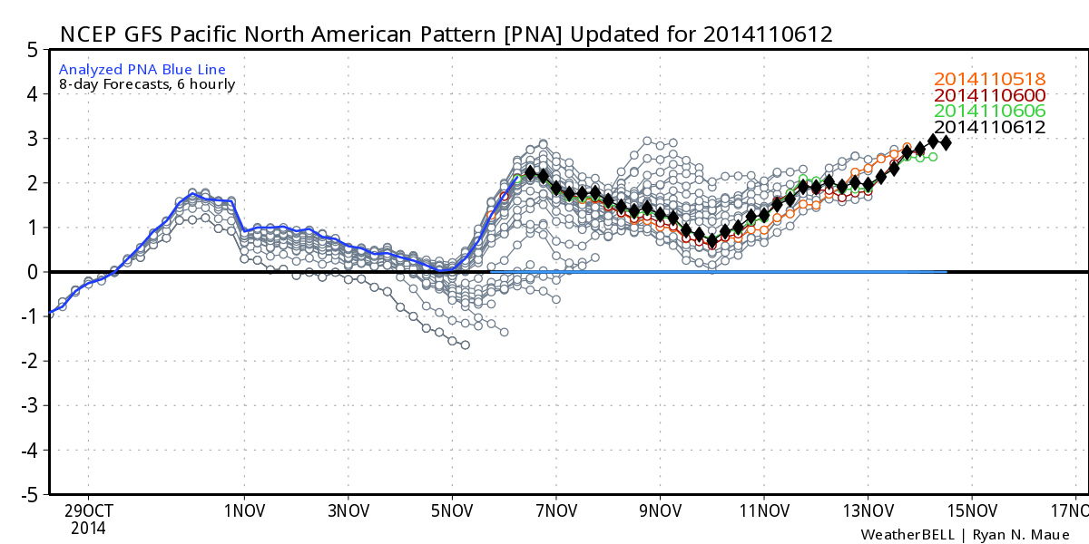
PNA (Pacific North American)
Next, lets look at the teleconnection/oscillation that influences the western US the most, the PNA. All you need to know (in a quick physics lesson) is that the jet stream wobbles up and down creating ridges and troughs. When there is a ridge in the western US, there is likely a trough downstream in the eastern US and vice-versa. The higher the ridge to the west, the deeper the trough to the east. Ever wiggle a rope on the ground to make it look like a slithering snake? The same physics are in play here only with the jet stream pattern. Last winter, there was continuous high ridging in the western US which brought record warmth and drought to that area. That represents the positive phase of the PNA. The negative phase of the PNA means a colder trough in the western US and a warmer ridge in the eastern US (generally). Bottom line…when California bakes in the winter, New Jersey is cold and vice-versa. Below is the predicted PNA heading into snow season:
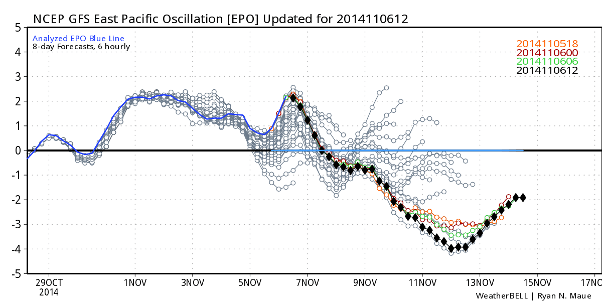
EPO (Eastern Pacific Oscillation)
The last teleconnection/oscillation I want to mention is the EPO. This was probably the biggest contributing factor to last winter’s below average temperature anomalies. The EPO is just like the PNA in the sense of ridge vs trough only just to the west of the PNA region. A positive phase of the EPO means ridging to the west of the PNA region which, again—physics, means a trough in the western US downstream (the wiggling rope). On the contrary, a negative phase of the EPO means a trough in the E. Pacific and a ridge in the W. US. A +EPO typically results in mild Pacific air mass moving into the US. A -EPO opens the arctic gates (like it did last winter). Below is the predicted EPO heading into snow season:
Northern Hemisphere Snow Cover
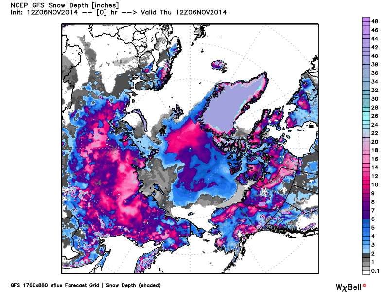
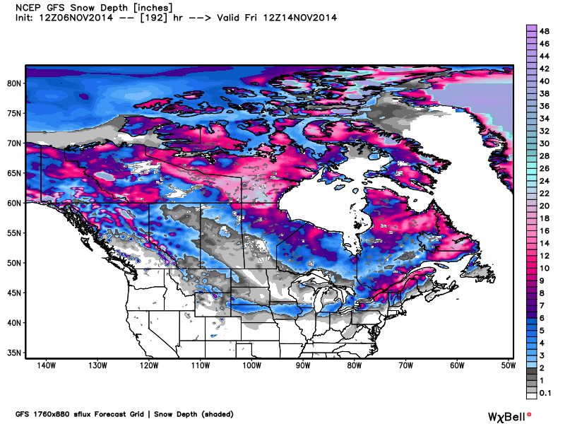
It’s only early November and snow cover in the northern hemisphere is growing at a record pace, especially in Eurasia. A hat tip to Meteorologist Joe Cioffi for pointing this out to me weeks ago when the trend started. Southern Canadian snow cover is expected to increase in the short-term as well. When storm systems crank off the mid-Atlantic, they pull down colder air from the north that injects into the natural snow-making machine that forms offshore. When more land to the north is covered by snow, it allows for a cooler injection to battle the warmer ocean moisture feed. This level of snow cover is well-known for setting up what’s called a stratospheric warming event where high pressure/warmer temps converge at the north pole (at the higher levels of the atmosphere) and displace polar vortex energy southwards into Europe, Asia, and North America. This happened a few times last year, hence the multiple polar vortex energy surges. The first image below represents current snow cover in the northern hemisphere (looking down at the north pole). It’s pretty amazing to see so much snow this early. The second image below represents expected Canadian snow cover 8 days from now. The second half of November should start with record collective northern hemisphere snow cover which should hold heading into meteorological winter (again…starts on December 1):
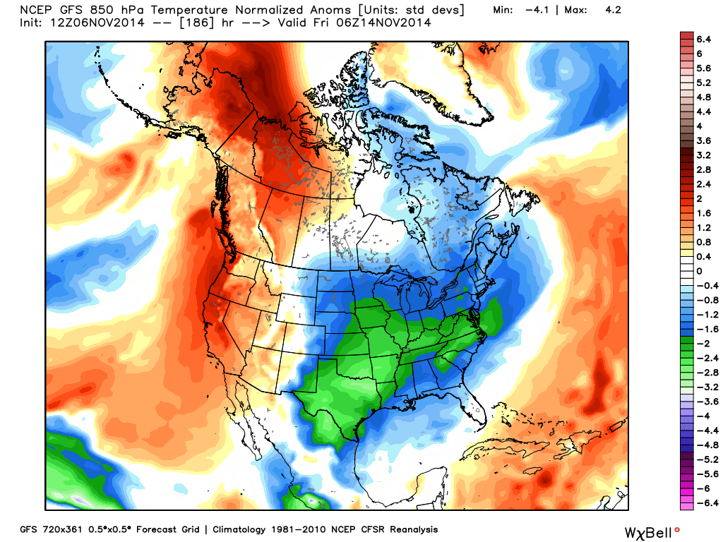
Early Arctic Air Invasion
The other day, I posted about an Arctic Outbreak expected towards the end of next week—which is holding stronger than ever on model guidance. This should be the first of many arctic waves heading into winter. The cold air should arrive around mid-week and stick around into the following week. Check out the expected temperature anomalies for next Friday:
Summary in English
The general setup in the northern hemisphere appears favorable for a cold and snowy start to the 2014-2015 meteorological winter (Dec 1 – Feb 28). I’m specifically talking about the second half of November, Thanksgiving and most of December. What about January and February you ask? That’s too far away for my comfort zone, especially taking into consideration how patterns can flip mid-season. Once we’re well into December, I’ll make a second winter call on the period starting with the holidays and ending in January. My third and last 2014-2015 winter call will then occur well into January to close out the season.
For those of you who have seen Major League (1989), you know what happens after Taylor calls his shot (main image of this article). Perhaps there is more at play here metaphorically than you think. Maybe the bunt is the lack of January-February discussion. My goal is to keep us all winning (prepared and safe) within my comfort zone. I’m looking forward to tracking each winter storm possibility with you that threatens New Jersey and its surrounding areas. I’ll leave you with the actual scene from Major League (1989) as posted on MOVIECLIPS. Be safe! JC
A special thanks to Dr. Ryan Maue (@RyanMaue) for the awesome job he does with weather models at WeatherBell Analytics.
Jonathan Carr (JC) is the founder and sole operator of Weather NJ, New Jersey’s largest independent weather reporting agency. Since 2010, Jonathan has provided weather safety discussion and forecasting services for New Jersey and surrounding areas through the web and social media. Originally branded as Severe NJ Weather (before 2014), Weather NJ is proud to bring you accurate and responsible forecast discussion ahead of high-stakes weather scenarios that impact this great garden state of ours. All Weather. All New Jersey.™ Be safe! JC


LOCAL FORECAST | INTERACTIVE RADAR | LATEST NJ WEATHER ALERTS | WEDDING FORECAST| PRIVACY POLICY
© Copyright 2025 Weather NJ LLC. All Rights Reserved.
Some information that can be found on our website is provided by a private weather station and is not an officially recognized station for weather reporting. Though we always strive to achieve accurate reporting for our own use, it is important that you do NOT depend on the data provided here for any purpose.
