

Jan 17: Possible Snow Storm Detected!
We have a lot to talk about.
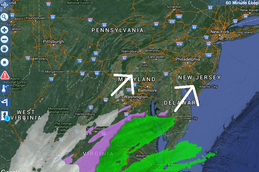
First, we have today’s possible light snow event. This was actually a system that I’ve been watching for a long time. It was aggressively modeled in a supportive pattern in the long-range forecasting period. It then trended completely out to sea in the mid-range—so far out to sea that light snow from the northern stream energy-only was being modeled for today. Now, in the short-range forecasting period, the coastal low has trended towards a larger precipitation shield to the N/NW of it.
The actual low’s track still remains modeled as a “southern slider” out to sea. But now with the larger precip shield snowfall is possible for SNJ and especially the SNJ coast today. The surface temperature profile is not ideal for accumulations but the mid-to-upper levels are certainly cold enough. Therefore if snowfall becomes heavy enough from a coastal band, it could overpower the surface and begin sticking. With that said, I think only SENJ coastal areas (and slightly inland into SNJ) have a chance for light accumulations when all is said and done this evening. Perhaps a dusting could fall as far as the I-95 corridor but there should be a sharp cutoff. Let’s set a general time window of noon to 8PM for all and any light-to-moderate snowfall to occur. Here’s the latest radar showing the precipitation approaching from the S:
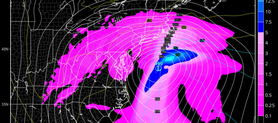
Now let’s talk about Friday-Saturday. Many of you snow lovers are feeling defeated so far this winter. El Nino typically results in a warmer winter overall but that doesn’t mean a snow storm can’t happen. Long-range model guidance has let us down several times this winter. But now we are within the mid-range forecasting period of the modeled January 22-23 (Friday-Saturday) possible snow storm. Guidance is almost unanimous at this point in showing organized energy crossing the US (from Pacific to Atlantic) and producing a major snow storm for the US for said period.

As of right now, I am only stating that a major snow storm is detected on model guidance in the mid-range forecasting period. I will be aggressively monitoring this potential over the next few days as the energy comes off the Pacific Ocean. If we’re still looking good on Tuesday then I will issue an initial snow map. Let’s all take a deep breath and think about how other systems fell off of model guidance in the past few weeks. There is no reason to panic nor ride any emotional roller coasters until about Tuesday. I will say though…this looks our best chance yet.
In English: Light snow is possible today between noon and 8PM. Should it over-perform then so be it but the snowfall will be fighting a warmer surface and possible virga (evaporates before hitting ground). Those are the wildcard scenarios. Therefore, anything from a dusting along the I-95 corridor to an inch along the coast is a safe conservative expectation. I’m then aggressively tracking a possible snow storm for the Friday-Saturday (January 22-23) period. It’s too early for details (expected accumulations and snow/rain line placement). For now the pattern is very favorable and all models are consensual on a mid-Atlantic hit. Be safe! JC
Jonathan Carr (JC) is the founder and sole operator of Weather NJ, New Jersey’s largest independent weather reporting agency. Since 2010, Jonathan has provided weather safety and forecasting services for New Jersey and immediate surrounding areas through the web, social media, and app spaces. Originally branded as Severe NJ Weather (before 2014), Weather NJ is proud to bring you accurate and responsible discussions ahead of high-stakes weather scenarios that impact the garden state. All Weather. All New Jersey.™


LOCAL FORECAST | INTERACTIVE RADAR | LATEST NJ WEATHER ALERTS | WEDDING FORECAST| PRIVACY POLICY
© Copyright 2024 Weather NJ LLC. All Rights Reserved.
Some information that can be found on our website is provided by a private weather station and is not an officially recognized station for weather reporting. Though we always strive to achieve accurate reporting for our own use, it is important that you do NOT depend on the data provided here for any purpose.
