

Jan 6: Final Call on Saturday Snow
Wave 1 has been weighed, measured and found wanting. Here’s the final call for wave 2 tomorrow…
A quick lesson on wave 1: A dry slot in precipitation opened up over coastal NJ overnight (pretty much exactly in the area we circled for potential over-performance). While the expectation was for coastal enhancement to fill this dry slot in quicker, something happened called mesoscale banding. Snowfall occurs from lifting. The pressure drops aloft and the surface responds by rising in attempt to equalize. The rising surface air contains more moisture (humidity) than the upper levels so eventually the drier and colder air aloft squeezes out the rising moisture into snow through a process called frontogenic forcing or frontogenesis. However when rising comes together in linear segments, they can produce bands of stronger lifting resulting in stronger frontogenesis. Areas parallel to these bands then try to equalize with sinking air…which cuts off snow production. So the stronger snow (meso band) last night occurred from SWNJ through about the 95 area and up through Somerset County…which cut off the the snow making machine for areas immediately SE (coastal NJ). Eventually the coastal low threw some energy in and filled in the precipitation shield. But by that time the coastal low was pulling away and ending precipitation (puling it away) from NW to SE. The event was expected to be light but certainly performed on the lower end of expectations overall. Onto wave 2…
Wave 2 Disco: Last night some of the shorter-range models over-corrected NW. I had a feeling they were a bit bullish (as I mentioned in my video). Today’s short-range models have backed off some and are showing a solution very similar to our first call yesterday. This will not be a consolidation of precipitation shields like last night (from west and from a coastal). Precipitation will come from a coastal low only (stronger than last night’s), off of the ocean. Therefore SENJ is favored for the higher accumulations given proximity to the low that will be tracking SE of the 40N/-70W benchmark. Tomorrow’s air mass will be very cold aloft, especially to the NW. Therefore, a sharp cut off is expected to form along the NW side of the precipitation shield. We feel that this precipitation shield will reach into NJ from the SE to about the I-95 corridor. Areas along I-95 and NW of such should expect little to no accumulation. Because it will be so cold, snow ratios might exceed the standard 10:1 (inches of snow to inches of liquid). All snowfall should occur for all regions at 26F of below. Our final call map (collaborated by Eastern PA Weather Authority and Weather NJ) takes all of this into consideration:
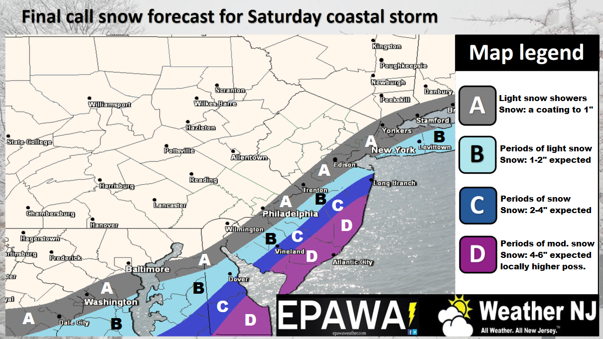
Click here to see high resolution version of snow map.
Wildcards (what could go wrong): There is wildcard potential in either direction with shifts of axis/orientation NW and SE, but the map/call is a rational middle ground. Slight shifts in track of the low pressure offshore or expansion of its associated precipitation shield by just 10 miles will have an obvious impact on totals with such a tight gradient separating isopleths. If the storm is slightly stronger and/or slightly closer to the coast then we bust high. If the strongest banding set up just offshore then it could rob NJ of accumulations. Again, our call represents the most rational range of possibilities given current model guidance and live observations of the atmosphere.
In English: Snow is expected tomorrow for areas SE of the I-95 corridor (as indicated on our map above). SENJ is expected to see the most amount of snow while areas to the NW should be mostly cut off from precipitations. The outer bookends of timing should be between 6am and 4pm. Be safe! JC
Jonathan Carr (JC) is the founder and sole operator of Weather NJ, New Jersey’s largest independent weather reporting agency. Since 2010, Jonathan has provided weather safety and forecasting services for New Jersey and immediate surrounding areas through the web, social media, and app spaces. Originally branded as Severe NJ Weather (before 2014), Weather NJ is proud to bring you accurate and responsible discussions ahead of high-stakes weather scenarios that impact the garden state. All Weather. All New Jersey.™


LOCAL FORECAST | INTERACTIVE RADAR | LATEST NJ WEATHER ALERTS | WEDDING FORECAST| PRIVACY POLICY
© Copyright 2024 Weather NJ LLC. All Rights Reserved.
Some information that can be found on our website is provided by a private weather station and is not an officially recognized station for weather reporting. Though we always strive to achieve accurate reporting for our own use, it is important that you do NOT depend on the data provided here for any purpose.
