

Jan 6: Snow Storm Update
We are raising expected snow totals for tomorrow. Here’s our new map…
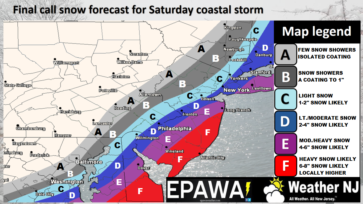
Click here to view full-resolution snow map.
Disco: We’re seeing impressive convection down south and now believe that the precipitation shield will expand to the NW past the I-95 corridor. This increases totals for most of New Jersey and naturally ups the expected jackpot zone from 4-6 to 6-8 inches. The low is not going to make a miraculous track to the NW. There is some room for that but the main reason for the increase is simply a larger precipitation shield generated from a more powerful low because of stronger dynamics aloft over the E US.
In English: SENJ is still expected to see jackpot accumulations from this system and areas to the NW are still expected to see a sharp cut-off. We’ve raised expected accumulations slightly and pushed the NW extent past I-95 however to account for what we’re seeing on live observations and the latest data. The general bookends of timing have been expanded to between 5am and 5pm tomorrow. The above updated snow map represents our updated call going into the system. Let the now-casting begin and please be safe! JC
Jonathan Carr (JC) is the founder and sole operator of Weather NJ, New Jersey’s largest independent weather reporting agency. Since 2010, Jonathan has provided weather safety and forecasting services for New Jersey and immediate surrounding areas through the web, social media, and app spaces. Originally branded as Severe NJ Weather (before 2014), Weather NJ is proud to bring you accurate and responsible discussions ahead of high-stakes weather scenarios that impact the garden state. All Weather. All New Jersey.™


LOCAL FORECAST | INTERACTIVE RADAR | LATEST NJ WEATHER ALERTS | WEDDING FORECAST| PRIVACY POLICY
© Copyright 2024 Weather NJ LLC. All Rights Reserved.
Some information that can be found on our website is provided by a private weather station and is not an officially recognized station for weather reporting. Though we always strive to achieve accurate reporting for our own use, it is important that you do NOT depend on the data provided here for any purpose.
