

July 30: Thunderstorms Expected!
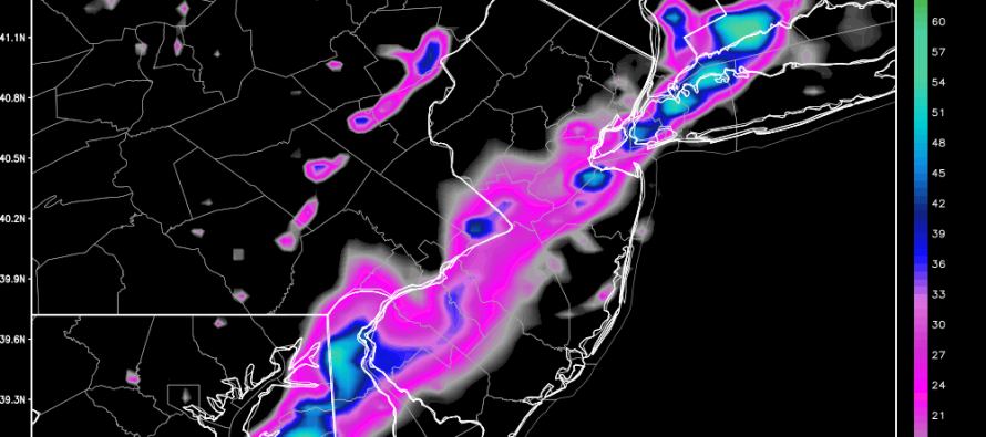
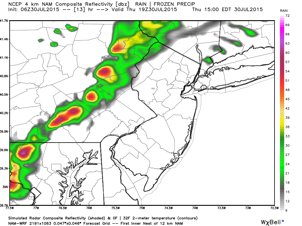
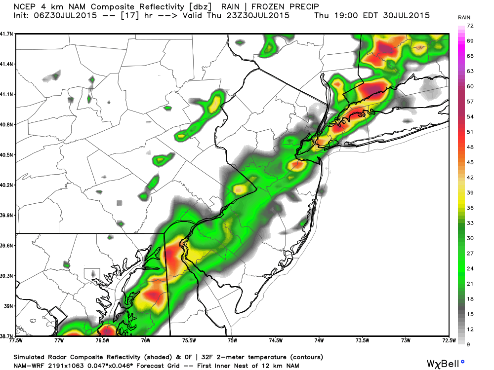
A cold front will push a line of showers and thunderstorms through New Jersey today from NW to SE. As far as timing goes, NWNJ will get hit first in the afternoon and SENJ will get hit last later this evening. General storm parameters (instability, shear and dew points) aren’t that impressive but enough to kick up run-of-mill summer cold front storm activity. Lets look at some supporting high-res NAM guidance showing estimated (simulated) precipitation intensity:
Between 2-3 PM:
Between 6-7PM:
Between 9-10PM:
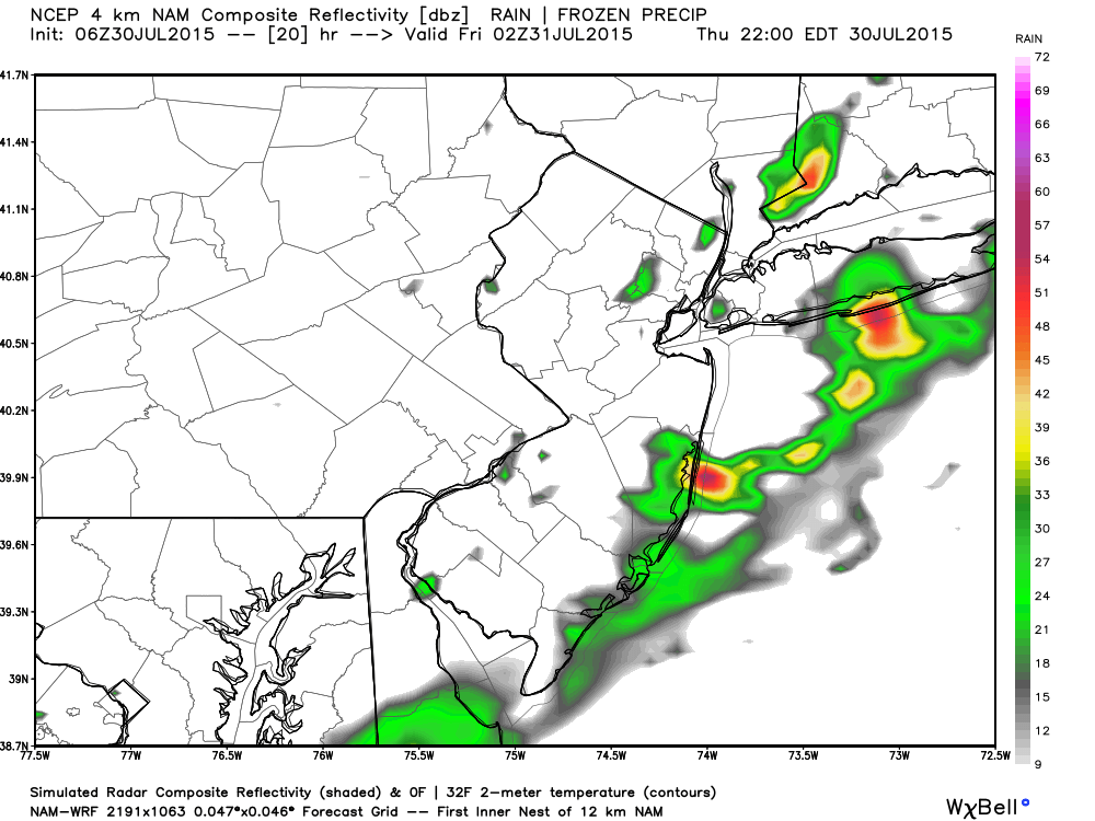
I wouldn’t count on this exact hourly timing but the general principal is a line of showers and storms that moves through between afternoon and evening. I’m fairly confident that most activity will fall below severe criteria however localized instances are possible should any down-drafting/rain-shafting produce an outflow boundary with wind gusts of 58mph or greater. The likely scenario is a 1-2 hour period of rain with some lightning and moderate wind gusts. Again, the atmosphere is not that impressive—decent instability, lacking wind shear, moderate dew points, and a trigger (the cold front). There is also some cloud debris ahead of the front which could inhibit/stunt thunderstorm development. By the time this storm line gets to coastal SENJ, it could be just a few showers and wind gusts with minimal lightning. We’ll see.
In English: Expect a mixed bag of sun and clouds with high temperatures reaching the mid-to-upper 80s this afternoon. 90 is not out of the question for interior urban areas (Philly-Trenton). Showers and storms should move through between afternoon and evening hours from NW to SE. This should be a short and brief period of outdoor nuisance/disruption but unfortunately it could time poorly with rush hour. I’ll be watching the radar and will have the weekend outlook posted later this evening. Be safe! JC
Jonathan Carr (JC) is the founder and sole operator of Weather NJ, New Jersey’s largest independent weather reporting agency. Since 2010, Jonathan has provided weather safety and forecasting services for New Jersey and immediate surrounding areas through the web, social media, and app spaces. Originally branded as Severe NJ Weather (before 2014), Weather NJ is proud to bring you accurate and responsible discussions ahead of high-stakes weather scenarios that impact the garden state. All Weather. All New Jersey.™


LOCAL FORECAST | INTERACTIVE RADAR | LATEST NJ WEATHER ALERTS | WEDDING FORECAST| PRIVACY POLICY
© Copyright 2024 Weather NJ LLC. All Rights Reserved.
Some information that can be found on our website is provided by a private weather station and is not an officially recognized station for weather reporting. Though we always strive to achieve accurate reporting for our own use, it is important that you do NOT depend on the data provided here for any purpose.
