

Long Range Outlook: Closing Out October

It’s time to harness the WeatherTrends360 proprietary weather algorithms for a look at the rest of October. But first lets break New Jersey into proper climatological regions. We have the upper elevations of NNJ/NWNJ, the interior coastal plain (SWNJ through CNJ and into NENJ), and the coastal regions (most of SENJ). I’ll be representing each climatological region with a 28-day graph from weathertrends360 data followed by a brief discussion. Please keep in mind that these algorithms are documented with an 84% verification rate and are based on oceanic water cycles and time table series.
Higher Elevations of NNJ/NWNJ
(Sussex, Warren, Hunterdon, Morris, N. Somerset, and N. Passaic) – Known for little to no Atlantic Ocean influence, colder-snowier winters, and drier conditions in general when compared to the coast. This region is known to get hot when high pressure sits overhead during the summer and bitterly cold during Arctic outbreaks in the winter.
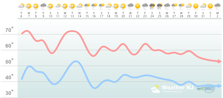
Discussion: The general trend for the first half of October looks like a roller coaster of temperatures with highs ranging from upper-50s to lower-70s. Rainfall appears to be minimal with lots of sun. Only a few days here and there of showers. The second half of October looks cooler and rather wet overall. I wouldn’t expect rain every day but definitely above-average precipitation in general. Highs should struggle to break 60 as we approach November. Overnight lows could threaten a frost a few nights in the first half of the month and especially the second half.
Interior Coastal Plain from SWNJ-CNJ-NENJ
(Salem, Gloucester, Camden, W. Burlington, Mercer, W. Monmouth, Middlesex, Union, Essex, Hudson, Bergen, and S. Passaic) – Known for naturally higher temperatures due to lower elevations away from the oceanic influence. This region is also known as “heat island” due to transportation (I-95 corridor), smog, abundant asphalt, concrete, and other man-made substances that naturally absorb and retain heat moreso than natural protected land.
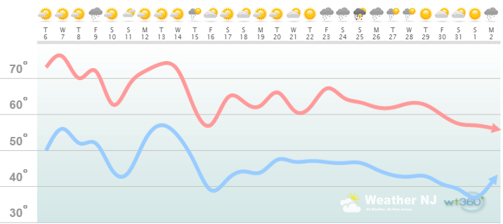
Discussion: The general trend for the first half of October looks like a roller coaster of temperatures with highs ranging from upper-60s to mid-70s. Rainfall appears to be minimal with lots of sun. Only a few days here and there of showers. The second half of October looks cooler and rather wet overall. I wouldn’t expect rain every day but definitely above-average precipitation in general. Highs should struggle to break 65 as we approach November and might have trouble breaking 60 around the Halloween period. Overnight lows could threaten a frost a few nights in the first half of the month and especially the second half.
Coastal Regions of SENJ
(Cumberland, Cape May, Atlantic, E. Burlington, Ocean, and E. Monmouth) – Known for tremendous influence from the Atlantic Ocean. Oceanic influence keeps this zone cooler in the summer and warmer in the winter than the interior coastal plain and especially the higher elevations of NWNJ. This forms a micro-climate that only local inhabitants and frequent visitors are familiar with.
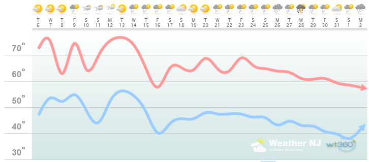
Discussion: The general trend for the first half of October looks like a roller coaster of temperatures with highs ranging from mid-to-upper 60s to mid-to-upper 70s. Rainfall appears to be minimal with lots of sun. Only a few days here and there of showers. The second half of October looks cooler and rather wet overall. I wouldn’t expect rain every day but definitely above-average precipitation in general. Highs should struggle to break 70 as we approach November and might have trouble breaking 60 around the Halloween period. Overnight lows could threaten a frost a few nights in the first half of the month and especially the second half.
Summary: We’re warmer and dry for the first half of October and cooler and wet the second half.
Tropical activity is the unforeseen caveat which cannot be detected until about 7-10 days from formation using global model guidance. We’re beyond peak hurricane season but we shouldn’t let our guard down until the season winds down in early November. What’s also very possible is a nor’easter or two this time of year, especially with the developing El Nino. Should a late season hurricane or classic October nor’easter happen, I’ll be on it immediately. Otherwise, a pretty run-of-mill October is predicted. Be safe! JC
Weathertrends360 is a complete, global, web solution to help retailers and suppliers capitalize on the weather and its influence on sales and marketing plans up to a year ahead. Learn how to become PROACTIVE vs REACTIVE with the weather in every phase of your business – how much inventory to buy/produce, where to allocate more/less, when to run weather-optimized advertising/marketing campaigns – weathertrends360 can help you determine all of this in minutes! 84% independently audited accuracy for both short-term and year-ahead forecasts for temperature and precipitation.
A forecast Weather Trends issued one year ago is more accurate than every other weather company’s 5 to 14-day forecasts. The University of Miami and West Point PhD Climatologist’s prove WTI’s year-ahead forecasts are several times more accurate than NOAA – Click to Download Report. Also check out their free txt and email alerts!
Jonathan Carr (JC) is the founder and sole operator of Weather NJ, New Jersey’s largest independent weather reporting agency. Since 2010, Jonathan has provided weather safety discussion and forecasting services for New Jersey and surrounding areas through the web and social media. Originally branded as Severe NJ Weather (before 2014), Weather NJ is proud to bring you accurate and responsible forecast discussion ahead of high-stakes weather scenarios that impact this great garden state of ours. All Weather. All New Jersey.™ Be safe! JC


LOCAL FORECAST | INTERACTIVE RADAR | LATEST NJ WEATHER ALERTS | WEDDING FORECAST| PRIVACY POLICY
© Copyright 2025 Weather NJ LLC. All Rights Reserved.
Some information that can be found on our website is provided by a private weather station and is not an officially recognized station for weather reporting. Though we always strive to achieve accurate reporting for our own use, it is important that you do NOT depend on the data provided here for any purpose.
