

Looking Good After Unsettled Friday (Aug 18-20)
Saturday and Sunday look much better than Friday. Also watching the tropics…
Discussion: A low pressure system tracking through the Great Lakes into SE Canada will drag a cold front through the region between Friday and early Saturday morning. As of right now, Friday rain looks hit-or-miss with on-and-off showers and thunderstorms. The entire day doesn’t look like a washout but certainly nuisance periods possible. I’m actually seeing a break in precipitation during the day between a possible pre-frontal trough and the trailing cold front. If all holds as currently expected, the rain could clear the east coast as early as late-Friday night but likely by sunrise on Saturday. Clouds and remnant humidity could linger, especially for the SENJ coast, but I’m not seeing much rainfall during busier/daytime hours on Saturday with Sunday looking even better. The cold front should have more impact on humidity/feel than temperatures for Saturday and Sunday. I’m still seeing highs well into the 80s.
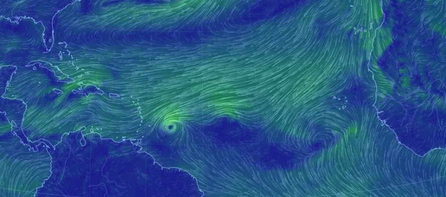
Tropics Update: Gert is long gone. 3 more waves have departed the W African coast. One just became named Harvey. Those with travel interests or anyone that lives in the Caribbean, possibly the Bahamas as well should closely monitor the tropics over the next 7-10 days. E Caribbean impact on the Lesser Antilles should be the first impact in the next few days as Harvey enters the Caribbean Sea from the E. It’s far too early to know what these systems will do beyond the Caribbean region for later next week. Anything from a Gulf of Mexico entrance to an east coast landfall to a fish storm is on the table until we can rule out steering currents through the mid-range forecasting period. For now these systems are moving across the Atlantic Ocean from E to W. Eventually they will be picked up by synoptic players and cast into the mid-latitude west flow. They have to go somewhere, assuming they hold at least organized low-level circulation. I’ll be ramping up tropics coverage if the Mid-Atlantic US region enters the game. For now, no immediate threats to the New Jersey coastline.
Friday (Aug 18) high temperatures should reach the low-to-mid 80s for most. Interior CNJ/SNJ could flirt with upper-80s/lower-90s. Skies should be mostly cloudy with rainfall and thunderstorms likely. A few sunny breaks with a humid feel. Winds should be light out of the S (unless under a thunderstorm). Overnight lows should fall into the 60s away from the ocean but possibly hang in the low-to-mid 70s along the coast.
Saturday (Aug 19) high temperatures should reach the low-to-mid 80s for most. Interior CNJ/SNJ could again flirt with upper-80s/lower-90s. Skies should feature a mixed bag of sun and clouds. Winds should be light out of the W. Overnight lows should fall into the 60s statewide with a comfortable feel.

Sunday (Aug 20) high temperatures should reach the low-to-mid 80s for most. Skies should be mostly sunny with a drier feel. Winds should be light out of the NW. Overnight lows should fall into the 60s for most, possibly the 50s for NNJ elevations.
An early look at next week indicates decent viewing conditions for the solar eclipse on Monday. View times are between ~1:15PM and 4PM with peak time of 2:45PM. We’re looking at a ~70-80% blockage from NJ but please use safe viewing methods when viewing. Otherwise next week should start out nice with humid and unsettled conditions returning mid-week. We’ll know more about the tropical systems and what they’re going to do Sunday night. Have a great weekend and please be safe! JC
Jonathan Carr (JC) is the founder and sole operator of Weather NJ, New Jersey’s largest independent weather reporting agency. Since 2010, Jonathan has provided weather safety and forecasting services for New Jersey and immediate surrounding areas through the web, social media, and app spaces. Originally branded as Severe NJ Weather (before 2014), Weather NJ is proud to bring you accurate and responsible discussions ahead of high-stakes weather scenarios that impact the garden state. All Weather. All New Jersey.™


LOCAL FORECAST | INTERACTIVE RADAR | LATEST NJ WEATHER ALERTS | WEDDING FORECAST| PRIVACY POLICY
© Copyright 2024 Weather NJ LLC. All Rights Reserved.
Some information that can be found on our website is provided by a private weather station and is not an officially recognized station for weather reporting. Though we always strive to achieve accurate reporting for our own use, it is important that you do NOT depend on the data provided here for any purpose.

)