

More Rain Approaches
Discussion: Another synoptic storm system will bring rain today through Friday, possibly Saturday. But it looks pretty good after that. Let’s break it down.
First, this will not be a significant rain and wind event like last week. For this event, we’re looking at .75-1.25 inches of total rainfall, not 3+. Wind gusts should commonly reach 25-35mph across NJ with maybe a few 40-45mph periods closer to the ocean, not 50-60mph+. Coastal flooding should be held to the minor category, not minor-to-moderate. So a much less impactful event, more in the category of nuisance than hazardous.
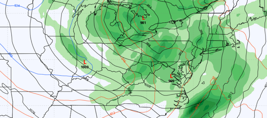
For those familiar with the Norwegian Cyclone Model, the warm front pushed in this morning and is currently draped across CNJ. This is why NNJ/ECNJ/SENJ coasties are in the 50s while WCNJ and SWNJ are above 70. This warm front should continue advancing northward, keeping the central and western regions of NJ warm but ENJ cooler via ocean air mass fetch. Rainfall activity yesterday and today (so far) has been very light. I expect rainfall to move in and pick up this afternoon but in the form of warm sector scattered showers, not a statewide slug of precipitation. A lot of on-and-off rain activity and that should be the nature of it overnight tonight (Thursday night) into Friday morning.
A cold front is then expected to push through NJ from W to E early Friday morning, likely by daybreak. This cold front should feature a congealed linear segment of rainfall and possibly some thunderstorm activity. Not really seeing a setup for severe thunderstorms, but certainly the possibility for embedded lighter thunderstorms (rolling thunder type stuff) with the Friday morning frontal precipitation. Once this cold-front related rainfall clears (by late Friday morning), the rest of Friday doesn’t look too bad…at least a lull, possibly some broken skies with temps ranging from upper-50s to mid-60s from NNJ elevations to SNJ coasts.
We then have a trailing disturbance that should push through NJ between Friday night and Saturday morning. This could bring additional rain showers with NNJ favored over SNJ but totals are very low. Very nuisance. This trailing disturbance should then clear all precipitation out of the region by mid-to-late Saturday morning and the rest of the weekend looks dry. Saturday/Saturday night will be the chillier period of the weekend as the departing secondary low’s cold front pulls some Canadian air down. Saturday highs should range from 40s in NNJ to 50s in SNJ. Sunday should quickly rebound into the 60s, possibly 70s away from the ocean in CNJ/SNJ with dry conditions. Next week then looks like 70s, possibly some 80s through Friday before what currently looks like a cooler weekend.
In English: Rain moves in this afternoon/evening (Thursday) and falls on-and-off through Friday morning. An inch, maybe 1.25 at most but possibly some rumbles early Friday morning. The rest of Friday then looks ok. More rain is then possible, mainly for NNJ between Friday night and Saturday morning. Most of Saturday looks dry but chilly and breezy (highs 55-63). Sunday looks like the better day (highs 60-72) with sunnier skies and less breeze. I’ll have a detailed weekend outlook posted tomorrow. But for now, just know that nuisance rain is moving through NJ this afternoon through tomorrow morning for all of NJ, then tomorrow night into Saturday morning for NNJ. Know that winds will pick up, and possibly howl a bit overnight tonight, but not be dangerous or considered high. Know that minor coastal flooding is possible through Friday. Run-of-mill NJ stuff but certainly nuisance and mildly disruptive. It still looks like the active rainy pattern should let up after this system. Be safe! JC
Premium Services
KABOOM Club offers inside info forecast discussion, your questions answered, and early storm impact maps (ahead of the public). At a buck per month, it’s an extremely feasible way to show support.
My Pocket Meteorologist (MPM), in partnership with EPAWA Weather Consulting, offers professional/commercial interests, whose businesses depend on outdoor weather conditions (snow plowing, landscaping, construction, etc.), with hyper-local text message alerts/forecasts and access to the MPM premium forum—the most comprehensive and technical forecast discussion available for PA and NJ.
Get your KABOOM Inside Out pajamas and more at the KABOOM shop!
Jonathan Carr (JC) is the founder and sole operator of Weather NJ, New Jersey’s largest independent weather reporting agency. Since 2010, Jonathan has provided weather safety and forecasting services for New Jersey and immediate surrounding areas through the web, social media, and app spaces. Originally branded as Severe NJ Weather (before 2014), Weather NJ is proud to bring you accurate and responsible discussions ahead of high-stakes weather scenarios that impact the garden state. All Weather. All New Jersey.™


LOCAL FORECAST | INTERACTIVE RADAR | LATEST NJ WEATHER ALERTS | WEDDING FORECAST| PRIVACY POLICY
© Copyright 2024 Weather NJ LLC. All Rights Reserved.
Some information that can be found on our website is provided by a private weather station and is not an officially recognized station for weather reporting. Though we always strive to achieve accurate reporting for our own use, it is important that you do NOT depend on the data provided here for any purpose.
