

Oct 1: Major Hurricane Matthew Turns
Alright Jersey. We’re getting closer so it’s time to get nerdy about Major Hurricane Matthew…
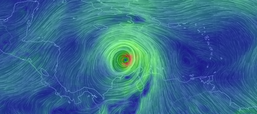
Right now, Major Hurricane Matthew is in the middle of the Caribbean Sea making the turn to the N. Today he weakened to a strong category 4 hurricane but I wouldn’t be surprised to see category 5 status re-achieved in the near future. Matthew could be setting up for what’s known as an Eyewall Replacement Cycle (ERC). This is when the eye disappears for a small period and re-appears. This is perfectly natural for a strong hurricane. Basically, it happens when a larger outer wind field around the eye rapidly intensifies around the inner eye. The inner eye wall then dissipates and the hurricane is left with a larger eye We might see this in the Caribbean before Matthew makes his way into the Bahamas but if we don’t then that’s normal too. Just something nerdy to look out for which I’ll point out if it happens. You’ll notice a little wobbling of the eye if/when this happens.
Not much else has changed. Jamaica, E Cuba, W Hispaniola and the Bahamas are in for a rough time with catastrophic winds and flooding between Monday and Thursday of this coming week. Water temperatures in the Bahamas are even warmer (30C = ~86F) than the W part of the Caribbean that Matthew has passed through (28-29C). This could aid in further intensification or at least slow any weakening that might occur. The elevations of Hispaniola (10k feet) and Cuba (5k feet) could inhibit Matthew. Normally these elevations have orographic and/or downsloping weakening influence on tropical systems but Matthew is a beast and might actually overcome this. Regardless, I think Matthew should emerge in the Bahamas at least as a category 2/3 storm after damaging the aforementioned areas as a category 4 (possibly 5) storm.
Beyond that lies tremendous uncertainty but I am able to narrow it down some to the following possibilities:
![]()
Scenario A: If you noticed, I took the inland track off the table which would be a Florida hit and overall dissipation over the interior US East Coast. This would mean that the ridge to E of Matthew remains stronger and bumps him closer to SE US coast. The cut-off upper-level low (that’s been plaguing us with current conditions) moves away to the E faster. Then the combo of W Atlantic ridge positioning and approaching W/C US trough tugging keeps Matthew closer to the coast.
Scenario B: This scenario would mean that the ridge E of Matthew breaks down more and allows a more offshore SE US passage. The cut-off upper-level low (that’s been plaguing us with current conditions) would be slower to depart and therefore would tug Matthew E a bit. The approaching W/C US trough would dig less and have less tugging influence in bringing him back to the W into the US East Coast. If a retrograde curve into US East Coast were to occur, it would be more likley into coastal New England than the coastal Mid-Atlantic US
Scenario C: This would be the most-desired outcome. The ridge E of Matthew would break down much quicker. The cut-off upper-level low (that’s been plaguing us with current conditions) hangs around and re-forms/re-strengthens slightly to the E of Matthew…tugging him hard out-to-sea. The approaching W/C US trough would then ahve little-to-no influence whatsoever.
The worst case scenario would be something between A and B (closer to A) which would mean hurricane-force winds, flooding rain and moderate-to-major coastal flooding. Something between B and C would result in fringe impacts only (rip currents, elevated swell). This is all going to come down to the upper-level synoptic pattern over the US which is still showing something different almost every run-to-run. The immediate danger threat to Jamaica, E Cuba, W Hispaniola and the Bahamas is very confident. Beyond that should end up between my A and C possibilities. All we can do is continue to track day by day and extend confidence further N with each tropical update.

In English: Jamaica, E Cuba, W Hispaniola and the Bahamas should either evacuate or take serious shelter ahead of the possible weather this coming Monday-Thursday. The entire US East Coast should have a plan in place…just in case the further W scenario verifies (between A and B above). We should all hope that something between B and C happens. The current timing estimation for New Jersey, whether direct hit or near-offshore passage, is looking like Saturday into Sunday of next weekend. That’s the absolute best I can do at this point and I look forward to narrowing the possibilities for you in the coming days. Thank you for your patience and understanding! Have a great night and please be safe! JC
Jonathan Carr (JC) is the founder and sole operator of Weather NJ, New Jersey’s largest independent weather reporting agency. Since 2010, Jonathan has provided weather safety discussion and forecasting services for New Jersey and surrounding areas through the web and social media. Originally branded as Severe NJ Weather (before 2014), Weather NJ is proud to bring you accurate and responsible forecast discussion ahead of high-stakes weather scenarios that impact this great garden state of ours. All Weather. All New Jersey.™ Be safe! JC


LOCAL FORECAST | INTERACTIVE RADAR | LATEST NJ WEATHER ALERTS | WEDDING FORECAST| PRIVACY POLICY
© Copyright 2025 Weather NJ LLC. All Rights Reserved.
Some information that can be found on our website is provided by a private weather station and is not an officially recognized station for weather reporting. Though we always strive to achieve accurate reporting for our own use, it is important that you do NOT depend on the data provided here for any purpose.
