

Stormier Conditions Approaching!
Discussion: Another slug of precipitation is just finishing up in NJ and departing out to sea. We should see a small lull this evening before more returns overnight into tomorrow (Wednesday). Tomorrow will likely feature the heaviest rainfall and stormiest conditions of this week.
Between tonight and tomorrow night, another low will track from the SE US right up the east coast. It should literally ride the NJ coast tomorrow as a sub-990mb low. Since there is a strong upper-low nearby (trailing the surface low), we’re going to see a cold injection. It should be cold enough to put most of NJ under rain with temperatures in the 30s (but above freezing)…a very cold rain. It’s still yet TBD the extent of wintry precipitation for NNJ/NWNJ elevations. Maybe some icing for the highest elevations. But I am leaning away from a significant accumulating snow event. Maybe some coatings above 1200ft. We’ll see. But for the lower 2/3 of NJ, a cold rain on Wednesday.
Because we will have the low nearby tomorrow (Wednesday), we should expect high winds, a period of coastal flooding, and possibly thunderstorms embedded within the precipitation. It doesn’t look catastrophic but definitely at least a horrible day for outdoor activities and travel interests. Expect delays and power outages.
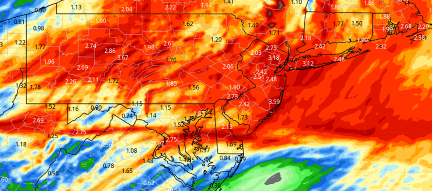
In addition to what has already fallen this week, most of NJ should expect another 1-3 inches of rainfall tomorrow. This could easily produce flash flooding conditions locally so please monitor NWS alerts. The ground is already very water-logged which will make it more difficult for standing water to drain.
The wind could be rough tomorrow. I would expect winds to build into gusts of 30/40mph overnight tonight through tomorrow morning. I then expect winds to gust to 50, possibly 60mph, during the peak storm impact mid-day tomorrow into the evening. Basically from 10am tomorrow to midnight tomorrow night, all of NJ is on the hook for high winds and all the power outages and fun things associated.
Coastal flooding is likely for both Wednesday high tides (~2am and ~2pm) and then for Thursday’s early AM tide (~230am). These three high tides will surround the greatest period of wind-driven storm surge for the Jersey coast. Luckily, the storm system is a fast mover and we won’t have a new or full moon in-place. That comes April 8 with the solar eclipse.
The stormiest conditions of the week should come to an end sometime between Wednesday night and Thursday morning. The upper-low however will meander around through Friday, likely producing a colder air mass and additional nuisance precipitation in the form of rain and/or snow. Snow would be more of a NNJ/NWNJ thing during overnight hours with little-to-no accumulation. Cold rain sprinkles for the rest (most) of NJ. Again, any snowflakes should be conversational not accumulative. We then clear out for an okay weekend but not mild. Next week and beyond still looking milder but with active stormy pattern continuing.
In English: Rain is coming to a short break for this evening. Rain then returns overnight and lasts through tomorrow (Wednesday) as temps remain colder through the rain. Winds should build tonight through tomorrow and peak tomorrow afternoon into evening hours. Gusts to 60mph not off the table during peak conditions. Otherwise gusts to 30/40mph should be common. Both flash flooding and coastal flooding are possible. Conditions calm down for Thursday and Friday but remain cold and unsettled with sprinkles/snow flurries around (mainly for NNJ/NWNJ elevations). Saturday and Sunday look much better with dry conditions, clearing skies, and temps in the 40s for Saturday and 50s for Sunday. Still seeing 60s, possibly 70s, for next week. Be safe! JC
Premium Services
KABOOM Club offers inside info forecast discussion, your questions answered, and early storm impact maps (ahead of the public). At a buck per month, it’s an extremely feasible way to show support.
My Pocket Meteorologist (MPM), in partnership with EPAWA Weather Consulting, offers professional/commercial interests, whose businesses depend on outdoor weather conditions (snow plowing, landscaping, construction, etc.), with hyper-local text message alerts/forecasts and access to the MPM premium forum—the most comprehensive and technical forecast discussion available for PA and NJ.
Get your KABOOM Inside Out pajamas and more at the KABOOM shop!
Jonathan Carr (JC) is the founder and sole operator of Weather NJ, New Jersey’s largest independent weather reporting agency. Since 2010, Jonathan has provided weather safety and forecasting services for New Jersey and immediate surrounding areas through the web, social media, and app spaces. Originally branded as Severe NJ Weather (before 2014), Weather NJ is proud to bring you accurate and responsible discussions ahead of high-stakes weather scenarios that impact the garden state. All Weather. All New Jersey.™


LOCAL FORECAST | INTERACTIVE RADAR | LATEST NJ WEATHER ALERTS | WEDDING FORECAST| PRIVACY POLICY
© Copyright 2024 Weather NJ LLC. All Rights Reserved.
Some information that can be found on our website is provided by a private weather station and is not an officially recognized station for weather reporting. Though we always strive to achieve accurate reporting for our own use, it is important that you do NOT depend on the data provided here for any purpose.
