

Stormy Night Developing
Discussion: This is not a snowstorm article although it’s February and I would love for that to be the case. Instead, this is an article about how rough it could get Wednesday night into early Thursday AM with the expected frontal passage. Remember, Weather NJ is All Weather All New Jersey, not just snow. The main function of Weather NJ is to provide safety awareness in hazardous weather conditions. Flash-flooding rain, coastal flooding, frequent lightning, high winds, hail, etc…all things that can greatly impact safety just as much, if not more so at times, than snow/ice hazards. With that said, here we are.
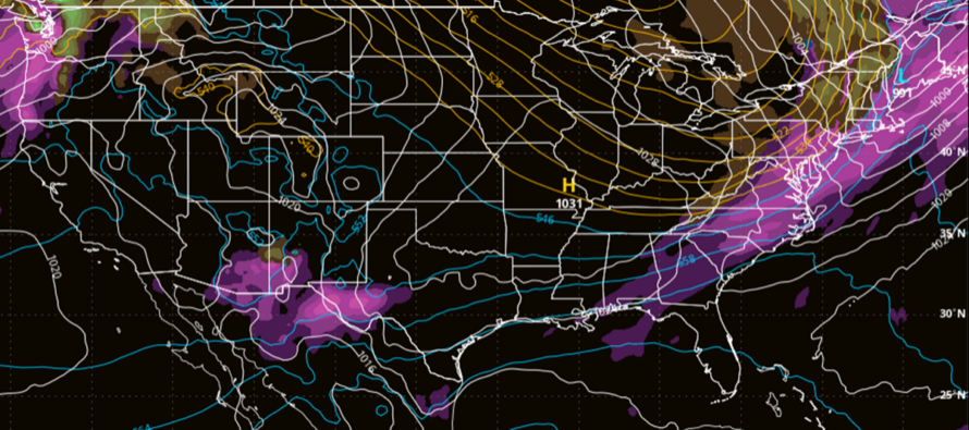
A low pressure system will track across the Great Lakes Wednesday morning and then cut sharply northward into E Canada (up near SE Hudson Bay) by noon Thursday. This should produce significant snow accumulations for parts of the Great Lakes and Northern New England. But for New Jersey, we will deal primarily with the cold front attached to the S side of this low.
The first part of this is already here. If you’re familiar with the Norwegian Cyclone Model, we’re already inside the warm sector. This is why many places are approaching 70 today in CNJ/SNJ with even NNJ elevations flirting with 60. Rain should start forming in the warm sector (over NJ) later tonight as S/SW winds begin to pick up.
Wednesday should remain warm with statewide on-and-off periods of light-to-moderate rain. Winds will be very different for immediate ECNJ/SENJ coastal areas vs. areas away from the ocean and up in the NNJ elevations. Coasties should see the highest wind gust values out of the S/SW on Wednesday/Wednesday night with gusts to 40-50mph possible. Some short range models are suggesting a period where gusts to 60mph are possible along the very immediate ECNJ/SENJ coast. Areas away from the coast should see lesser wind gusts but still to 20-25mph range likely. The main theme of Wednesday day and evening will be warm, S/SW winds, and rain.
Wednesday night is where it gets hairy. There’s a lot of shear and strong atmospheric dynamics up there with the actual frontal passage. We expect the cold front to push through between late Wednesday night and early Thursday AM. S/SW winds will scream their loudest just ahead of the cold front. NJ could then see omnidirectional gusty winds associated with heavy precipitation-generated meso gust fronts directly under/ahead of the frontal storm activity. Lightning is also possible although less common this time of year. You need warm surface air under cold air aloft for convective precipitation and lightning…and we have that. So, if you see a Severe Thunderstorm Warning issued Wednesday night (tomorrow night), you know that criteria for wind speed (local gusts of 58mph or greater) and/or hail size has been met. Once the cold front has passed over your NJ location, the heavy rain and erratic higher winds should relax as temps sharply drop for the few hour window before Thursday sunrise.
Thursday should be a Fleetwood Mac “listen to the wind blow, watch the sunrise” kind of morning/day. NJ will be behind the cold front and all atmospheric levels should feature stiff W/NW wind flow. Winds should not be as gusty as they were on Wednesday prior to the frontal passage or Wednesday night during the frontal hit. But they should affect all of NJ, not just the coasties, with sustained W/NW winds of 15-25mph and gusts to 30-35mph.
Thursday into Friday should then feel chilly in the transient cold sector of the overall system. Thursday looks windier but not too cold. Thursday night less windy but likely the coldest point heading into Friday. A cold start Friday morning before temperatures moderate back to a milder pattern Friday night through about March 8.
In English: We’re mild and cloudy today (Tuesday) and tomorrow (Wednesday). Rain moves in this evening/tonight and falls on-and-off for most of tomorrow. Winds increase by Wednesday afternoon/evening (mainly for coastal areas – gusts 40-50mph Wed night) with heavy rain, gusty winds, and possibly thunderstorms overnight into early Thursday AM…an overnight rain and wind event. Rain totals should be in the .5 to 2 inch range with NNJ favored closer to 2 and SNJ closer to .5. Thursday then looks colder with W/NW stiff winds setting up a short cold period through Friday. Warmth and rain chances return for this weekend with a milder pattern lasting through about March 8. Have a great night and please be safe! JC
Premium Services
KABOOM Club offers inside info forecast discussion, your questions answered, and early storm impact maps (ahead of the public). At a buck per month, it’s an extremely feasible way to show support.
My Pocket Meteorologist (MPM), in partnership with EPAWA Weather Consulting, offers professional/commercial interests, whose businesses depend on outdoor weather conditions (snow plowing, landscaping, construction, etc.), with hyper-local text message alerts/forecasts and access to the MPM premium forum—the most comprehensive and technical forecast discussion available for PA and NJ.
Get your KABOOM Inside Out pajamas and more at the KABOOM shop!
Jonathan Carr (JC) is the founder and sole operator of Weather NJ, New Jersey’s largest independent weather reporting agency. Since 2010, Jonathan has provided weather safety and forecasting services for New Jersey and immediate surrounding areas through the web, social media, and app spaces. Originally branded as Severe NJ Weather (before 2014), Weather NJ is proud to bring you accurate and responsible discussions ahead of high-stakes weather scenarios that impact the garden state. All Weather. All New Jersey.™


LOCAL FORECAST | INTERACTIVE RADAR | LATEST NJ WEATHER ALERTS | WEDDING FORECAST| PRIVACY POLICY
© Copyright 2024 Weather NJ LLC. All Rights Reserved.
Some information that can be found on our website is provided by a private weather station and is not an officially recognized station for weather reporting. Though we always strive to achieve accurate reporting for our own use, it is important that you do NOT depend on the data provided here for any purpose.
