Summer to Flex Harder
Discussion: The upper jet, observed at 250mb, should stay to the N of NJ through Wednesday and then dip below NJ heading into the weekend. This jives with 500mb analysis of a broad central US ridge giving way to a


Discussion: The upper jet, observed at 250mb, should stay to the N of NJ through Wednesday and then dip below NJ heading into the weekend. This jives with 500mb analysis of a broad central US ridge giving way to a

Discussion: Upper level analysis for this week indicates a zonal jet overhead above the bottom tip of a progressive trough for Monday-Tuesday. A ridge then builds over NJ Wednesday into the weekend. This creates two different planets of look and

Discussion: Thanks to an overnight cold front, today feels better. The zonal upper level patten should continue through the weekend until a ridge sets up in the Midwest US and puts NJ under N/NW upper flow for Monday-Tuesday. The zonal

Discussion: What I’m seeing in the upper levels is the jet stream remaining to the N of NJ this entire week with positive geopotential height anomalies locked in. Not a defined ridge because the pattern is rather zonal. But this

Discussion: For the “wake me up when it snows” crowd, we’ve lost about 14 minutes since peak June daylight as we begin our initial descent towards the colder months. In the meantime, summer rages on with warm temps, relentless humidity,
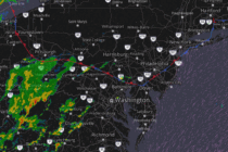
Discussion: I’m thinking “Relentless Stormy Humidity” was a good title for this week’s weekly outlook. Last night’s (Tuesday night) storms produced most violently in WCNJ/SWNJ before fizzling a bit for the coast. NNJ saw less intense action. A few tornado
Discussion: With actual temps over 90 for most of NJ and dew points well into the 70s, most of NJ is sitting with a heat index of ~100-110 less Sussex County…as of about 4pm. I’m seeing some high levels of

Discussion: I hope everyone had a great July 4th weekend! As promised, Friday was spectacular, and Saturday-Sunday saw a slow rebuild of humidity and temperatures. Here we are today (Monday) when the relentless humidity was expected to return. And that

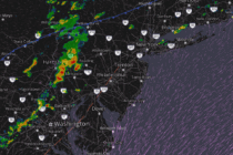
Discussion: A small trough is approaching NJ and will swing through between today (Thursday) and Sunday. As it approaches closer tonight (Thursday night), expect a series of showers and thunderstorms to start their strongest in NWNJ around 5-7pm and then
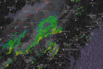
Discussion: It’s time for a cold front to push all this humid storminess out of the region. It’s going to be a process that starts tonight and ends Friday morning. Let’s dive into it… The surface map (shown above) indicates

LOCAL FORECAST | INTERACTIVE RADAR | LATEST NJ WEATHER ALERTS | WEDDING FORECAST| PRIVACY POLICY
© Copyright 2025 Weather NJ LLC. All Rights Reserved.
Some information that can be found on our website is provided by a private weather station and is not an officially recognized station for weather reporting. Though we always strive to achieve accurate reporting for our own use, it is important that you do NOT depend on the data provided here for any purpose.


