

4th of July Fireworks Forecast
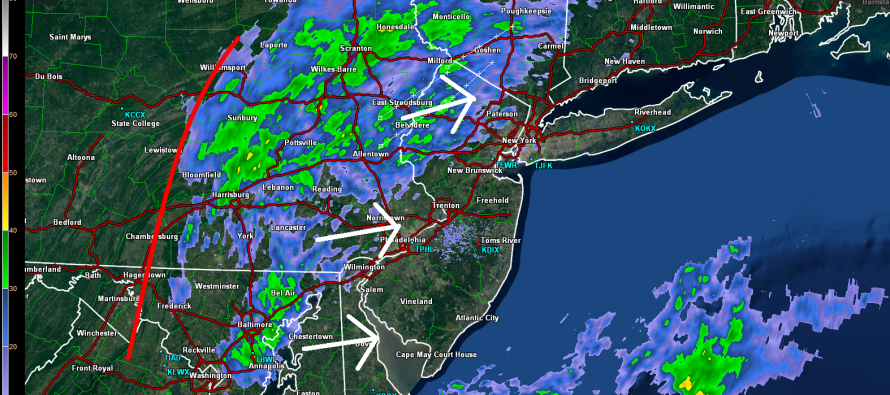
Rain showers currently span from Baltimore, through E. PA and into NWNJ. They will continue to push east in a scattered nature (not widespread) until ultimately fizzling by early evening. Satellite imagery indicates a wall of much drier air moving in (red line) from the WNW in association with sinking high pressure to our west. As a result, the frontal boundary that’s been affecting us all week should temporarily sink to our south, allowing for a cooler and drier period heading into this week.
In English: Expect nuisance conditions (anything from cloudy skies to drizzle/light rain) until about 6PM, felt moreso for interior/NWNJ than coastal/SENJ. Many coastal areas, currently swollen with population, should luck out during the day today. Some will not. After that, everything else remaining should clear in time for fireworks and a beautiful end to the weekend. Be safe! JC
Jonathan Carr (JC) is the founder and sole operator of Weather NJ, New Jersey’s largest independent weather reporting agency. Since 2010, Jonathan has provided weather safety discussion and forecasting services for New Jersey and surrounding areas through the web and social media. Originally branded as Severe NJ Weather (before 2014), Weather NJ is proud to bring you accurate and responsible forecast discussion ahead of high-stakes weather scenarios that impact this great garden state of ours. All Weather. All New Jersey.™ Be safe! JC


LOCAL FORECAST | INTERACTIVE RADAR | LATEST NJ WEATHER ALERTS | WEDDING FORECAST| PRIVACY POLICY
© Copyright 2025 Weather NJ LLC. All Rights Reserved.
Some information that can be found on our website is provided by a private weather station and is not an officially recognized station for weather reporting. Though we always strive to achieve accurate reporting for our own use, it is important that you do NOT depend on the data provided here for any purpose.
