

Sept 29: Hurricane Matthew Video and Storm Impact Map
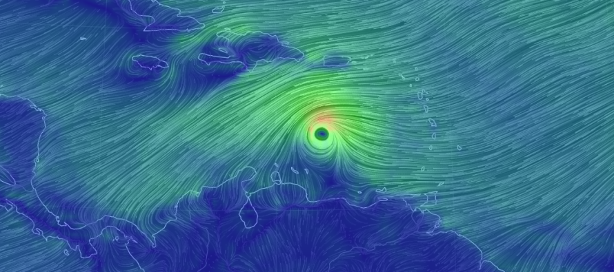
Matthew strengthened into a hurricane earlier today and will now churn in the Caribbean Sea before turning up the US East Coast. Let’s break it down…
I mentioned a few times now that I would be using a new forecasting strategy for large-scale events such as this. My goal is to have a great discussion of probability with the public while providing plenty of advanced-warning for those who like to prepare early. With that said, here is my new product:
![]()
Scenario A: If Matthew drifts a little further to the W in the Caribbean before making the turn, then he could slam into the SE US somewhere between E Florida and South Carolina (maybe some of S North Carolina). This would be devastating to the SE US but would likely then slide up the US East Coast as widespread large pockets of moderate-to-heavy rainfall. Winds and coastal flooding potential would be on the minor-to-moderate side for New Jersey but nothing crazy. This would be the best case scenario for the current drought situation. Soil hydration without a crazy storm. This scenario would result in the widespread rain reaching us during the second half of next week.
Scenario B: This would be the worst cast scenario for New Jersey and surrounding coastal interests (OBX/Delmarva/NYC/Long Island/etc). This would mean that Matthew tracks directly into the W side of a perfectly positioned W Atlantic ridge with “some” upper-level central US trough interaction (just enough to counteract any ridge weakness that would allow the system to escape out to sea). If this scenario were to happen, it would be between next Wednesday and Saturday with Thursday-Friday being the likely mean of that time period.
Scenario C: This would be the best case scenario. It would mean Matthew finds a weakness in the ridge with little-to-no C US trough interaction. Matthew would then miss the US East Coast out-to-sea. However, he might pass close enough for fringe sprinkles, minor to moderate winds and some flooding for coastal areas and just inland—basically nuisance conditions without the disaster. It might even pass just far enough out to sea to only bring light winds and surf. Such conditions would likely be closer to mid-week than late-week as a far eastern track would likely be a slightly quicker track.

In English: Hope for A or C but know that B is possible. I think it’s a little early to start preparing for B but perhaps at least a plan is good to have should ithappen. I feel that this represents all possibilities on the table at the current time with no shortage of advanced heads-up warning for what could be. Reality should be somewhere between A and C as all solutions are still currently on table and they pretty much all span from next Wednesday to Saturday. Have a great night and please be safe! JC
Jonathan Carr (JC) is the founder and sole operator of Weather NJ, New Jersey’s largest independent weather reporting agency. Since 2010, Jonathan has provided weather safety discussion and forecasting services for New Jersey and surrounding areas through the web and social media. Originally branded as Severe NJ Weather (before 2014), Weather NJ is proud to bring you accurate and responsible forecast discussion ahead of high-stakes weather scenarios that impact this great garden state of ours. All Weather. All New Jersey.™ Be safe! JC


LOCAL FORECAST | INTERACTIVE RADAR | LATEST NJ WEATHER ALERTS | WEDDING FORECAST| PRIVACY POLICY
© Copyright 2026 Weather NJ LLC. All Rights Reserved.
Some information that can be found on our website is provided by a private weather station and is not an officially recognized station for weather reporting. Though we always strive to achieve accurate reporting for our own use, it is important that you do NOT depend on the data provided here for any purpose.
