

Rough Start (April 13-17)
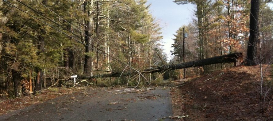
Discussion: This week is all about the damaging wind potential on Monday. After that it’s boring. Slightly cooler than we’d all like for this time of year but uneventful as the below daily forecast indicates. So let’s talk about Monday. Right now (Sunday evening) low pressure is near Arkansas and will take a sharp turn northward through the Great Lakes and into SE Canada through Monday. This will create an extremely unstable warm sector for the Mid-Atlantic US which should flex against departing high pressure in the Atlantic. This will create a tight pressure gradient and likely support a strong wind profile out of the S. The 850mb S/SW jet is modeled near 80 kts (close to 100mb). That’s about 5,000 feet up. Lots of diurnal instability and vertical wind shear should power strong convection in the form of lift and rain-driven downdrafts which could bring some (not all) of those winds down to the surface. By the time they extrapolate to the surface then some of those models indicating gusts to 80mph could verify. I’d say the most reasonable expectation are gusts of 50-65mph. But just in case the computers are correct, you have to assume a gust between 70-80mph is possible. Rain approaches late-tonight through tomorrow morning along a warm front. This shouldn’t be too bad. By late-morning Monday winds should be howling out of the S/SW (not the dangerous/damaging stuff yet but def whipping). Then at some point between late-morning and afternoon a linear storm line should push through ahead of the cold front. This will be the area of concern with the highest shear profile and potential to produce damaging wind gusts (most likely straight line but possibly tornado). Current data supports SNJ with more risk than NNJ but no one is off the hook. Once it’s all through by early-evening then just strong, stiff and straight line winds will persist but gradually subside Monday night into Tuesday morning.
Monday (April 13) high temperatures should reach the mid-to-upper 60s for most areas. You might see some interior CNJ/SNJ locations break 70. Skies should feature a mixed bag of sun, clouds and thunderstorms. Thunderstorm downpours could be heavy at times and could feature severe-criteria hail and/or winds. A small possibility of tornadoes cannot be taken off the table. Winds should be gusty out of the S leading up to afternoon damaging wind potential. Prepare for likely power outages, downed trees, etc. Overnight lows should fall into the 40s for most areas.
Tuesday (April 14) high temperatures should reach the mid-to-upper 50s for most areas. Skies should be mixed with sun and clouds. Winds should be light out of the W. Overnight lows should range from upper-30s to lower-40s NNJ to SNJ as some light rain approaches. A small chance of colder mixed precipitation is possible for NWNJ elevations overnight.
Wednesday (April 15) high temperatures should reach near-50 for most areas. Skies should start cloudy and rainy but improve by late-afternoon into evening. Winds should be light out of the NW. Overnight lows should range from near-30 to near-40 NNJ to SNJ.
Thursday (April 16) high temperatures should reach the low-to-mid 50s for most areas. Skies should be mixed with sun and clouds. Winds should be light out of the W. Overnight lows should range from near-30 to near-40 NNJ to SNJ.
Friday (April 17) high temperatures should range from near-50 to near-60 NNJ to SNJ. Skies should be mixed with sun and clouds with a few showers around. Winds should be light out of the S/SE. Overnight lows should range from mid-30s to mid-40s.
An early look at the weekend indicates calm conditions with highs ranging from upper-50s into the 60s. Everyone have a great week and please be safe! JC
Download the new free Weather NJ mobile app on Apple and/or Android. It’s the easiest way to never miss Weather NJ content. Our premium services go even further above and beyond at the hyper-local level. Looking for industrial-caliber long-range forecasting data that I personally recommend? Check out WeatherTrends360! Visit the Weather NJ Kaboom Shop for hoodies, tees and infant onesies.
Jonathan Carr (JC) is the founder and sole operator of Weather NJ, New Jersey’s largest independent weather reporting agency. Since 2010, Jonathan has provided weather safety discussion and forecasting services for New Jersey and surrounding areas through the web and social media. Originally branded as Severe NJ Weather (before 2014), Weather NJ is proud to bring you accurate and responsible forecast discussion ahead of high-stakes weather scenarios that impact this great garden state of ours. All Weather. All New Jersey.™ Be safe! JC


LOCAL FORECAST | INTERACTIVE RADAR | LATEST NJ WEATHER ALERTS | WEDDING FORECAST| PRIVACY POLICY
© Copyright 2026 Weather NJ LLC. All Rights Reserved.
Some information that can be found on our website is provided by a private weather station and is not an officially recognized station for weather reporting. Though we always strive to achieve accurate reporting for our own use, it is important that you do NOT depend on the data provided here for any purpose.

)