

Nov 15: Windy Conditions
Discussion: When I was younger, before I studied the science of meteorology, I would falsely associate prolonged wind events in the months of spring and fall. I thought these events, for said periods, were the seasons blowing in and out. Strong S/SW winds of spring came before warming (ultimately transitioning winter to summer) and likewise strong N/NW winds of fall before cooling (ultimately transitioning summer to winter). Was I wrong? Yes and no. “Many of the truths we cling to depend greatly on our own point of view.” -Obi-Wan Kenobi.
Tonight, we have one of these wind events and it will certainly transition us from milder to colder conditions. However, let’s talk about the science of it first. A sub-980mb low is currently tracking from the Great Lakes to the NE through SE Canada. This low has a large synoptic grip on the entire E side of North America. It will follow the proven principals of the Norwegian Cyclone Model and affect New Jersey with a warm sector, frontal passage, and cold sector. With a very tight pressure gradient of tight isobars surrounding the low’s center of circulation, we can expect some higher winds with it.
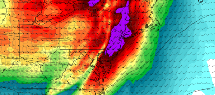
We’re seeing the warm sector today with stronger winds out of the S—producing a milder feel (for mid-November). I expect these winds to increase intensity between now and when the cold front arrives later this evening. Let’s call this now through about 8pm. Therefore, I wouldn’t be surprised to see S wind gusts of 40-60mph along the ECNJ/SENJ immediate coastal regions with tapering values inland. The 850mb lower-level jet, as seen in the above cover image, should be ripping.
Rainfall, possibly heavy at times, is possible between about 8pm and midnight tonight. The area of rain could be a very thin strip of precipitation that moves from W/NW to E/SE. A 15-30-minute downpour that moves through in that ~8pm-midnight window. This rain will be located along and just ahead of the cold front. I’ve seen thunderstorms happen in this type of setup before, but the main safety hazards are 1 – a short period of heavy rainfall and 2 – gusty winds produced by the lower-level jet/frontal interaction.
By midnight, maybe 2am for the ENJ coasts, the cold front should move through. You’ll this when rain ends, temperatures drop, and wind direction changes to W/NW. I don’t expect these winds to be as strong as the S winds ahead of the front (to occur earlier this evening). But I expect them to at least howl overnight into tomorrow. At some point tomorrow morning/afternoon I expect winds to subside but remain northerly through at least Wednesday night, possibly Thursday morning. This should produce average to below-average temperatures for at least the first half of this coming week. If I were younger, I would say winter is starting to blow in.
In English: Strong S winds should continue to build and reach peak intensity this evening. SENJ/ECNJ should notice it most. A short but heavy period of rain is then likely between about 8pm and midnight (from WNJ to ENJ). Shortly after midnight, a cold front should then push through and drop temperatures as skies clear. W/NW winds behind the cold front should be stiff overnight but subside tomorrow. This should produce a colder first half of the week which I’ll cover in the Monday-Friday outlook later tonight. Be safe! JC
Download the free Weather NJ mobile app on Apple and/or Android. It’s the easiest way to never miss Weather NJ content. Our premium services go even further above and beyond at the hyper-local level.
Jonathan Carr (JC) is the founder and sole operator of Weather NJ, New Jersey’s largest independent weather reporting agency. Since 2010, Jonathan has provided weather safety discussion and forecasting services for New Jersey and surrounding areas through the web and social media. Originally branded as Severe NJ Weather (before 2014), Weather NJ is proud to bring you accurate and responsible forecast discussion ahead of high-stakes weather scenarios that impact this great garden state of ours. All Weather. All New Jersey.™ Be safe! JC


LOCAL FORECAST | INTERACTIVE RADAR | LATEST NJ WEATHER ALERTS | WEDDING FORECAST| PRIVACY POLICY
© Copyright 2026 Weather NJ LLC. All Rights Reserved.
Some information that can be found on our website is provided by a private weather station and is not an officially recognized station for weather reporting. Though we always strive to achieve accurate reporting for our own use, it is important that you do NOT depend on the data provided here for any purpose.
