

New Jersey Winter Storm Forming
Discussion: Okay, we’ve seen enough. It’s time to get ready for this coastal winter storm. Let’s break this forecast discussion into the following categories:
Trends and Observations
The models have all shifted W since yesterday’s update. Most models by a lot and some (the GFS) only a little. This is because they are seeing a healthier ridge in the W US with less cyclonic vorticity left behind in the S stream of energy. This is allowing the model output to suggest a surface low popping offshore of South Carolina Friday evening and riding a little closer to the coast as it tracks from S/SW to N/NE just SE of the 40N/70W benchmark through Saturday night. As the low passes to the E of NJ, it will bring us our snowstorm. So it’s a powerful S to N ocean storm (like the one that produced the Dec 2010 Boxing Day Blizzard and January 4, 2018 winter storms). Some models have been struggling with the surface low placement once to the W of NJ. It suggests an elongated surface low pattern stretching from SW to NE. This doesn’t fit meteorologically given the suggested intensity of the low and upper-level trough axis/amplification. It would make more sense to have a strong low radiate with concentric isobars rather than indicate a transfer. For these reasons, we see the GFS as an outlier and are leaning towards a Euro/RGEM/NAM blend of model guidance to support our call. FWIW, the Euro is matching up with live observations on the W US coast best.
Temperature and Snow Ratios
One thing is certain. NJ will be on the cold side of this storm. Never are we to the E or S of it. We’re going to have Arctic air injecting into the system over our heads and that’s going to make for a cold snowfall. Every layer of the atmosphere will be well below zero forming a perfect snow dendrite growth zone for anywhere it does snow. On Friday, much of NJ will rise above freezing during peak afternoon high temperature time. But temps will then drop below freezing for all through sunset and especially during the storm. Peak snowfall should happen in temperatures of upper-teens/near-20. The colder it is, the more snow is produced from an inch of liquid. 10:1 is a very wet snow and happens a lot when temperatures are marginal, especially near the coast. 10:1 is common (that’s inches of snow produced for every inch of rain that would have fell if it was above freezing). Because of how cold it will be, snow rations could be in the 12:1 to 15:1 ratio maybe even a little higher. So expect a very powdery snow not the slushy wet stuff. This is in part why snow accumulations could easily outperform expectations on the high side.
Storm Intensity and Wind
The coastal low is expected to start around 1004mb off SC and bomb down into the 970’s (mb) by the time it reaches benchmark latitude. That’s going to produce a large wind field in the Western Atlantic which should batter NJ. Winds will first be out of the E to start Friday night then cyclonically rock in wind direction to the N/NE by Saturday afternoon. As the system pulls away Saturday PM, NJ will then see winds turn N/NW. During the peak storm intensity (Saturday mid-to-late morning) winds could gust to 60mph along the coast and to 45mph inland. This should present power outage issues mostly related to winds knocking down snow filled or weak tree branches. Winds should then subside through Sunday morning.
Coastal Flooding
There are three high tides of concern (early Saturday AM, Saturday afternoon, and then early Sunday AM). Luckily the strongest wind surge period (the middle of the three tides) is the lower of the three astronomical high tides. If it was the first or third higher astronomical tide, then there would be major concern along the Jersey Shore. But that’s not the case and therefore coastal flooding should be held to the minor-to-moderate categories. The initial E flow to start is short and NJ will therefore experience most of the heavier winds out of the N/NE which is better for coastal flooding than E or SE flow. For the sake of safety, lets assume that one of the three tides of concern could possibly reach the upper area of moderate coastal flooding.
Timing
Light snow from the initial northern stream could break out across NJ anytime after sunset Friday but likely by midnight. Snow should then fill in and spread through NJ between early and mid-Saturday AM. The heaviest snow should occur between mid-Saturday AM and mid-Saturday PM before tapering off around or just after sunset Saturday evening. Saturday night into Sunday will then be extremely cold with the snowpack and Arctic NW winds.
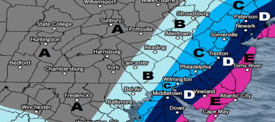
Snow
We feel the following snow map is a conservative first call meaning amounts could easily exceed it. We are weighing a wide spread of model guidance in a highly volatile setup. There are some models showing way more and some less. Therefore, you should expect these amounts at the least for planning and safety. Tomorrow we will likely tweak the map some as a last call heading in. But for now, this is where we stand on expected snow accumulation amounts:
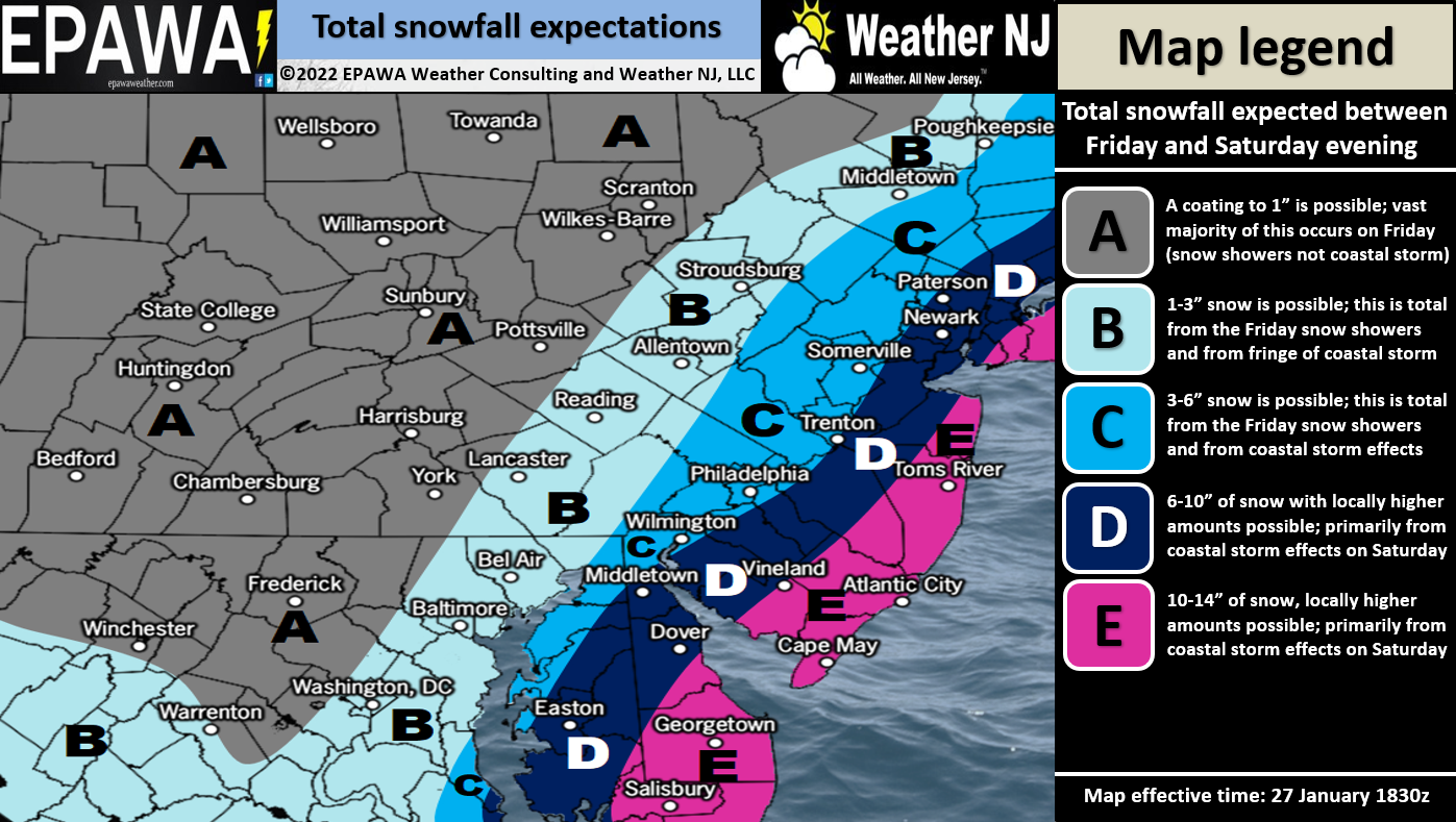
Full Resolution Snow Impact Map
In English: A significant-to-major snowstorm is developing and will impact New Jersey from late Friday night through mid-Saturday PM with peak conditions occurring Saturday AM into Saturday afternoon. The storm should taper off late Saturday afternoon through Saturday evening. The above snow map represents our thoughts on snow accumulations but is very conservative. As discussed in numerous articles leading up to this, it favors NJ areas SE of NJTP rather than areas NW of. Expect wind gusts up to 40-60mph (interior to coasts) which will likely contribute to power outages. Expect at least minor, likely moderate coastal flooding along the ECNJ/SENJ shore. Tomorrow will be another update with some map tweaks if needed. Have a great rest of your Thursday and please be safe! JC
Download the free Weather NJ mobile app on Apple or Android. It’s the easiest way to never miss Weather NJ content. Our premium services go even further above and beyond at the hyper-local level.
Jonathan Carr (JC) is the founder and sole operator of Weather NJ, New Jersey’s largest independent weather reporting agency. Since 2010, Jonathan has provided weather safety discussion and forecasting services for New Jersey and surrounding areas through the web and social media. Originally branded as Severe NJ Weather (before 2014), Weather NJ is proud to bring you accurate and responsible forecast discussion ahead of high-stakes weather scenarios that impact this great garden state of ours. All Weather. All New Jersey.™ Be safe! JC


LOCAL FORECAST | INTERACTIVE RADAR | LATEST NJ WEATHER ALERTS | WEDDING FORECAST| PRIVACY POLICY
© Copyright 2026 Weather NJ LLC. All Rights Reserved.
Some information that can be found on our website is provided by a private weather station and is not an officially recognized station for weather reporting. Though we always strive to achieve accurate reporting for our own use, it is important that you do NOT depend on the data provided here for any purpose.
