

Major Winter Storm Approaching New Jersey
Discussion: A major winter storm is knocking on New Jersey’s door. Some lighter stuff has already fallen today and it looks like things are going to kick off in SWNJ/SNJ very soon. Let’s break the final forecast discussion (before live observations begin) into the following categories (some info unchanged from yesterday):
Trends and Observations
The latest data is locked into the idea of a major ECNJ/SENJ snowstorm possibly back to the NJTP/I-95 corridor with significant snowfall now reaching WNJ and NWNJ. The latest model runs are close enough to the storm that hurricane hunter dropsonde data is being factored into the computers. The N stream injection looks strong and W. The S stream has sped up. The low’s convective feedback issues were resolved. We’re pretty locked into a consensus here and we have appropriately weighed a full blend of all models and live observations into this forecast.
Temperature and Snow Ratios
One thing is certain. NJ will be on the cold side of this storm. Never are we to the E or S of it. We’re going to have Arctic air injecting into the system over our heads and that’s going to make for a cold snowfall. Every layer of the atmosphere will be well below zero forming a perfect snow dendrite growth zone for anywhere it does snow. On Friday, much of NJ will rise above freezing during peak afternoon high temperature time. But temps will then drop below freezing for all through sunset and especially during the storm. Peak snowfall should happen in temperatures of upper-teens/near-20. The colder it is, the more snow is produced from an inch of liquid. 10:1 is a very wet snow and happens a lot when temperatures are marginal, especially near the coast. 10:1 is common (that’s inches of snow produced for every inch of rain that would have fell if it was above freezing). Because of how cold it will be, snow rations could be in the 12:1 to 15:1 ratio maybe even a little higher. So, expect a very powdery snow not the slushy wet stuff. This is in part why snow accumulations could easily outperform expectations on the high side.
Storm Intensity and Wind
The coastal low is expected to start around 1004mb off SC and bomb down into the 970’s (mb) by the time it reaches benchmark latitude. That’s going to produce a large wind field in the Western Atlantic which should batter NJ. Winds will first be out of the E to start Friday night then cyclonically rock in wind direction to the N/NE by Saturday afternoon. As the system pulls away Saturday PM, NJ will then see winds turn N/NW. During the peak storm intensity (Saturday mid-to-late morning) winds could gust to 50mph along the coast and to 40mph inland. This should present power outage issues mostly related to winds knocking down snow filled or weak tree branches. Winds should then subside through Sunday morning.
Coastal Flooding
There are three high tides of concern (~4AM Saturday, ~4PM Saturday, and then ~4AM Sunday). The first of the three now looks slightly higher than the following two. All of them present a good chance of moderate coastal flooding but would enter the major category if verified any higher. To recap from yesterday, we’ll have a short period of onshore flow overnight before winds become NW or even N/NW for the majority of the storm (while it’s to our E). NE and N/NE flow is much kinder to the inlets that are mostly facing an E/SE or SE direction along the Jersey Shore. For that reason, I don’t think we’re looking at major flooding up and down the coast…but likely solid moderate.
Timing
Light snow from the initial northern stream has already fallen across parts of NJ today and some better bands are currently forming over SWNJ/SNJ. The main event should begin around midnight or just after. A gradual build up of light-to-moderate snowfall this evening leading into midnight. Snow should fill in on radar and spread through NJ between early and mid-Saturday AM. The heaviest snow should occur between 2AM Saturday and 2PM before tapering off around or just after sunset Saturday evening for far-E coastal regions. Saturday night into Sunday will then be extremely cold with the snowpack and Arctic NW winds.
Snow
As we said with yesterday’s map, it was conservative and just the general idea of what to expect for planning and safety. I noted how I thought we would likely expand the heavier snow N and NW while increasing amounts. Well, here we are. This is our final call snow map heading into this winter storm:
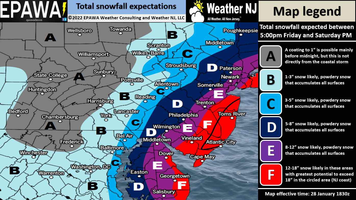
A small wildcard to note. The heaviest snowfall of the entire system is modeled just offshore of Ocean County and will likely go on to hit New England. We’re talking about a “finger of God” band with ridiculous frontogenic forcing known as the deformation zone…3-5 inch per hour rates of snow. I’ll point it out on radar obs when I see it. Will either be offshore (most likely) or just right over E Ocean County-ish (less likely) This morning’s 6Z NAM brought that band into Ocean County and surrounding areas but has since backed off to something more like our snow map above. I will allow a 5-10% chance of that happening which would really verify the + of the 12-18+ we have in said areas. But I do not have enough evidence to back it in a forecast. Just mentioning the possibility.
In English: Snow is already falling across parts of NJ. This is not the main event, just building bands ahead of it. The main event should be from about 2AM to 2PM tomorrow give or take a few hours. It’s a large storm. Winds and heavier snow should pick up and fill in anytime near or just after midnight tonight. Conditions should peak Saturday morning then taper off tomorrow afternoon into evening. A KABOOM is expected for all of area E and likely area D. See the above snow map for details about expected snow accumulations. Winds are going to crank and coastal areas which normally flood from run-of-mill nor’easters are likely going to flood. You won’t see a drop of rain from this system. It will be cold enough for an all-snow event. Good luck to everyone. Live observations begin now. Be safe! JC
Download the free Weather NJ mobile app on Apple or Android. It’s the easiest way to never miss Weather NJ content. Our premium My Pocket Meteorologist (MPM) services go even further above and beyond at the hyper-local level for commercial/professional interests.
Jonathan Carr (JC) is the founder and sole operator of Weather NJ, New Jersey’s largest independent weather reporting agency. Since 2010, Jonathan has provided weather safety discussion and forecasting services for New Jersey and surrounding areas through the web and social media. Originally branded as Severe NJ Weather (before 2014), Weather NJ is proud to bring you accurate and responsible forecast discussion ahead of high-stakes weather scenarios that impact this great garden state of ours. All Weather. All New Jersey.™ Be safe! JC


LOCAL FORECAST | INTERACTIVE RADAR | LATEST NJ WEATHER ALERTS | WEDDING FORECAST| PRIVACY POLICY
© Copyright 2026 Weather NJ LLC. All Rights Reserved.
Some information that can be found on our website is provided by a private weather station and is not an officially recognized station for weather reporting. Though we always strive to achieve accurate reporting for our own use, it is important that you do NOT depend on the data provided here for any purpose.
