

Erin Forms
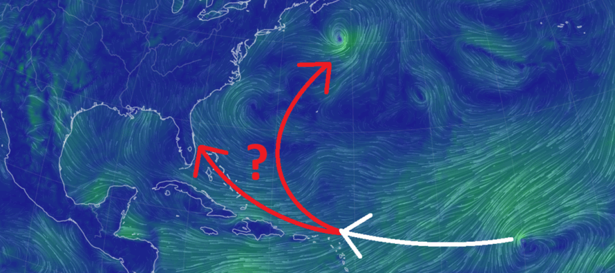
Discussion: We have ourselves a ~Verde origin system worth watching as it crosses the Atlantic Ocean via the trade winds over the next several days and ultimately decides where to go from either just over the NE Antilles or just to the NE of that.
First I’m going to cover the rest of this week first. Wednesday looks warm and humid, near-90 for many. Daytime looks good but thunderstorms could be around for late-afternoon-overnight hours. Thursday doesn’t look as hot as Wednesday but still humid with more thunderstorms around. Friday looks hotter again with humidity but more settled and less chances for storms. The weekend should remain hot and humid little storm chances outside of very isolated pop-ups (off sea breeze fronts, etc.). Watch out for strong rip currents with the persistent onshore flow into ECNJ/SENJ. Otherwise, the weekend looks great for boat, beach, and water stuff. Please stay as cool and hydrated as your situation allows for. The focus for next week will be heavily on Erin regardless of what she does. And for Erin, I have a bowling analogy…
From New Jersey’s vantage point of being a perfect strike, Verde origin systems are like lousy bowlers. And just like lousy bowlers, they throw lots of gutter balls (into the Gulf or a curve miss out to sea). It takes a specific thread the needle of a lot of moving parts for a Verde system to curve just right to hit NJ. Remember, NJ hasn’t been hit by a hurricane in a long time (over 100 years). Sandy (2012) was reclassified as an extra-tropical cyclone before landfall. Irene (2011) was downgraded to a Tropical Storm just prior to landfall. Gloria, 1944, etc. were grazes but not landfalls. Like in bowling, it takes a lot to throw that perfect curving strike. With that said, it is certainly possible for Erin (formed yesterday off the W Verde area) to affect NJ in about a week to 10 days from now, but there’s a much better chance of a gutter ball. At least we are now within a window of time where it makes sense to start tracking Erin a little more seriously.
The trend over the last 24 hours has been a weaker tropical system mainly due to Erin passing over colder water and pushing into a large area of dry air on its NW side. The weaker immediate expectation has flattened Erin’s expected track a little…more towards the NE Caribbean islands rather than a clear miss of the NE Caribbean islands (the leewards). A weaker system will want to do that…continue heading W rather than curving to the N and interacting with mid-latitude features. A stronger system will want to curve more to the N. So if we see some restrengthening over the next few days, expect a clear miss of the NE leeward islands. If it remains weaker then we could be looking at more of a threat to the NE leewards. Erin should be to this point sometime this weekend and that will set the stage for where it will go next week.
I’m noticing that the Bermuda high will float over towards the Azores this weekend into next week which should open up the steering currents to bring Erin northward around the W side of the high, to the E of the ridge that looks to park over the interior SE US. But again, we have to see if the system has remained weaker with more of a W movements vs stronger with more of a W/NW movement before we can deduce what type of track it will take relative to the US East Coast. An earlier curve N means out to sea. A later curve N could mean an OBX/Delmarva/NJ scrape/hit. Right now I am leaning towards the former, but we are absolutely knowledgeless until Erin is at Lesser Antilles longitude.
If you need probability numbers that I’m comfortable throwing out right now, my gut says there’s a 10% chance Erin continues weaker and enters the Caribbean, missing the E US to the S (could mean remnant impacts down the road but not a tropical strike). There’s a 70% chance Erin curves and stays out to sea. There’s a 30% chance Erin impacts somewhere between FL and Cape Cod with at least fringe/secondary impacts and a low single-digit chance Erin hits NJ with damaging impact. These chances will obviously change as Erin evolves between now and this weekend as it approaches the NE Caribbean/N Lessers.
In English: The rest of the week should remain hot and humid with Wednesday and Thursday featuring the best thunderstorm chances. Friday-Sunday looks hot and humid but more settled/stormless. I’m watching Erin between now and the weekend to get a sense of where it will be in relation to the NE Caribbean before likely turning N and curving. The above discussion lays out the possibilities based on such. Have a great rest of your Tuesday night and please be safe! JC
Premium Services
KABOOM Club offers ad-free content, inside info forecast discussion, your questions answered, and early storm impact maps and video releases (ahead of the public). At $1.99 per month, it’s an extremely feasible way to show additional support for Weather NJ and you can can turn it on and off for however many months you wish. Think of it as a tip jar with perks. The public eventually sees all info discussed in premium areas. Available onFacebook or Patreon.
My Pocket Meteorologist (MPM), in partnership with EPAWA Weather Consulting, offers professional/commercial interests, whose businesses depend on outdoor weather conditions (snow plowing, landscaping, construction, etc.), with hyper-local text message alerts/forecasts and access to the MPM premium forum—the most comprehensive and technical forecast discussion available for PA and NJ.
Jonathan Carr (JC) is the founder and sole operator of Weather NJ, New Jersey’s largest independent weather reporting agency. Since 2010, Jonathan has provided weather safety discussion and forecasting services for New Jersey and surrounding areas through the web and social media. Originally branded as Severe NJ Weather (before 2014), Weather NJ is proud to bring you accurate and responsible forecast discussion ahead of high-stakes weather scenarios that impact this great garden state of ours. All Weather. All New Jersey.™ Be safe! JC


LOCAL FORECAST | INTERACTIVE RADAR | LATEST NJ WEATHER ALERTS | WEDDING FORECAST| PRIVACY POLICY
© Copyright 2026 Weather NJ LLC. All Rights Reserved.
Some information that can be found on our website is provided by a private weather station and is not an officially recognized station for weather reporting. Though we always strive to achieve accurate reporting for our own use, it is important that you do NOT depend on the data provided here for any purpose.
