

The Tropics are Lighting Up
Discussion: The tropics of the Atlantic Basin are showing signs of life after a relatively quiet 2025 hurricane season so far (for NJ interests). There are currently three systems of interest in the Atlantic Ocean.
First is Gabrielle which represents the least amount of risk to NJ/E US. Gabrielle sent some enhanced surf into the Jersey shore last week but that was about it as it passed just E of Bermuda. It is now in the western Atlantic and heading towards Europe, possibly through the Azores, with no further consideration needed by E US interests. All discussions going forward this week will focus on the next two systems.
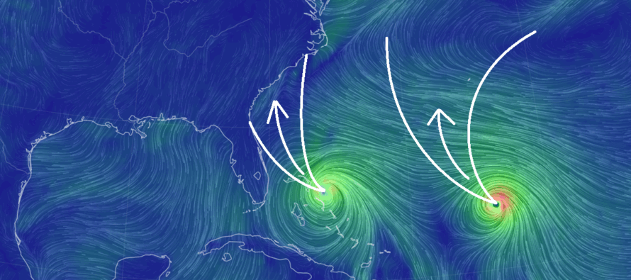
Second is Tropical Storm Humberto, currently a few hundred miles NE of the Lesser Antilles. At this point in time, Humberto looks to stay out in the ocean, re-curving near Bermuda (like what Gabrielle did) around Mon-Wed of next week (Sept 28-Oct 1). While Humberto could potentially bring a more serious outcome to Bermuda, it would likely only send in more enhanced surf/rip currents to the E US/NJ coasts without rain and wind.
Third and last, for now, is currently an area of investigation (Invest 94L) by NOAA NHC. In my opinion, this is the one to watch for E US concerns, especially the SE US coast. Unless something else forms rapidly in the next few days (unlikely), Invest 94L should become Tropical Depression 9 and then Imelda if named a Tropical Storm/Hurricane. Current expectations for what could become Imelda, would be a track along the northern Greater Antilles, up through the Bahamas and into the SE US coast somewhere between Jacksonville, FL and OBX between Monday-Tuesday (Sept 29-30). The upper pattern as well as strong high pressure over the SE Canada/NE US would then suggest the system stalling out over the immediate interior SE US without tracking northward towards towards NJ. Perhaps a few outer bands make it into SNJ but the core of the system would remain well to the S/SW of NJ. Looking even further into the future, the remnants of Imelda could possibly swing through NJ later next week.
Yesterday, model guidance was actually suggesting a Fujiwhara effect which is when two tropical systems revolve around a centralized area of high pressure. It’s an absolutely chaotic scenario if realized but is rare as a unicorn. It’s becoming clearer to me that Humberto curving off towards Bermuda (staying out to sea) and Imelda striking the SE US coast is a more realistic scenario with little, if any, Fujiwhara effect.
So, it’s Thursday today which means 4-5 days before Imelda likely threatens the SE US and 5-6 days before Humberto threatens Bermuda. As of now, Humberto should have minimal impact on NJ, outside of coastal surf enhancement and Imelda is yet to be determined what its remnants would do once the system dissipates inland of the SE US.
I’ll have the weekend outlook posted tomorrow for NJ but as of now, the rest of Thursday should remain muggy and unsettled with rain and possibly thunderstorms into early Friday AM hours. A cold front will kick out the humidity some by reducing dew points from 70s to 60s but the true relief (dews down to 40s/50s) looks to hold off until about Tues-Wed of next week. This should make for a stormy night tonight (Thursday), a much-improved Friday, and some scattered shower activity Saturday night into Sunday morning. Whenever there are tropical systems, especially multiple tropical systems, it drastically changes the entire pattern. It will be a very volatile situation with lots of forecast changes but that’s how it looks now after reviewing the latest data and live observations.
In English: There are no direct hit threats to NJ from what will soon be Tropical Storm/Hurricanes Humberto and Imelda. These systems post direct hit threats to the SE US coast this coming Mon-Tues and to the Bermuda area this coming Tues-Wed. As of right now for NJ, it looks like just coastal surf enhancement from Humberto and then rainy/stormy remnants from Imelda later next week. My cones of uncertainty are represented in the above cover image. I will be following closely and reporting accordingly. Be safe! JC
Premium Services
KABOOM Club offers ad-free content, inside info forecast discussion, your questions answered, and early storm impact maps and video releases (ahead of the public). At $1.99 per month, it’s an extremely feasible way to show additional support for Weather NJ and you can can turn it on and off for however many months you wish. Think of it as a tip jar with perks. The public eventually sees all info discussed in premium areas. Available onFacebook or Patreon.
My Pocket Meteorologist (MPM), in partnership with EPAWA Weather Consulting, offers professional/commercial interests, whose businesses depend on outdoor weather conditions (snow plowing, landscaping, construction, etc.), with hyper-local text message alerts/forecasts and access to the MPM premium forum—the most comprehensive and technical forecast discussion available for PA and NJ.
Jonathan Carr (JC) is the founder and sole operator of Weather NJ, New Jersey’s largest independent weather reporting agency. Since 2010, Jonathan has provided weather safety discussion and forecasting services for New Jersey and surrounding areas through the web and social media. Originally branded as Severe NJ Weather (before 2014), Weather NJ is proud to bring you accurate and responsible forecast discussion ahead of high-stakes weather scenarios that impact this great garden state of ours. All Weather. All New Jersey.™ Be safe! JC


LOCAL FORECAST | INTERACTIVE RADAR | LATEST NJ WEATHER ALERTS | WEDDING FORECAST| PRIVACY POLICY
© Copyright 2026 Weather NJ LLC. All Rights Reserved.
Some information that can be found on our website is provided by a private weather station and is not an officially recognized station for weather reporting. Though we always strive to achieve accurate reporting for our own use, it is important that you do NOT depend on the data provided here for any purpose.
