

Humberto/Imelda Update
Discussion: I was happy to see the rain hold off today, allowing as much dry daytime hours as possible. As mentioned in the weekend outlook earlier, this is a weak disturbance moving through. The low is currently pushing from NC into VA and will be offshore by morning. Most rain overnight should stay along and SE of I-95/NJTP and clear out by 8am or so tomorrow (Sunday) morning. Areas NW of I-95/NJTP have been missing out on precipitation. Once this clears out, we could be in quite a dry stretch…
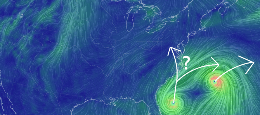
Humberto has blown up into a category 5 major hurricane. Humberto is currently about 600 miles due E of the Bahamas and about 500 miles S/SE of Bermuda. Humberto’s suggested track has been consistent for the past few days, passing just W of Bermuda and then curving back to the E staying out to see and offshore from the E US. There is no doubt in my mind that Humberto will rough up Bermuda with at least rain, wind and storm surge between Monday and Wednesday with the worst of it occurring Tuesday. Hopefully the slightly W of Bermuda track holds otherwise any slight shift E would mean Bermuda taking a major hurricane to the face. For NJ/E US coastal interests, we’re looking at increased waves heights, hazardous rip currents and some more beach erosion between Monday evening and Wednesday evening. No rain or wind impacts are expected for NJ from Humberto. Best of luck, Bermuda!
Imelda has not yet formed to the point of a named Tropical Storm. It is still in Tropical Depression status (TD09). Humberto and Imelda could very well interact with each other in a Fujiwhara effect (where two tropical systems revolve around a common center – like colliding galaxies). Imelda is not expected to hit NJ either, however the SE US coast is still on the hook. The latest data has trended towards Imelda getting close to the SE US coast but possibly staying offshore. It’s all going to depend on the influence of a boss ridge in Canada and an associated boss area of high pressure sinking out of SE Canada across the NE US. This ridge/high is expected to form a “thou shall not pass” blocking situation for Imelda once Imelda gets closer to the SE US coast around Tuesday.
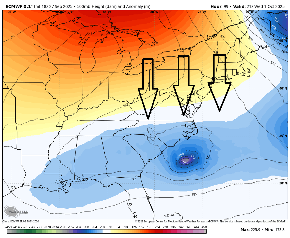
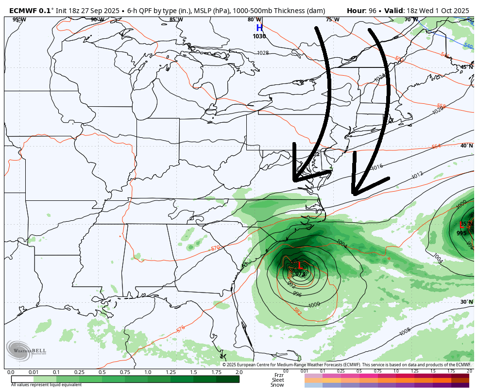
One of two things could happen. The high pressure could doink Imelda out to sea, following Humberto. Or Imelda could get trapped beneath the high and possibly stall just S of OBX for a few days. This would weaken Imelda to just a coastal low situation, but it could then slide up the coast towards NJ later this week with the S flow on the W side of the high. This is still yet TBD. But in either case, neither Humberto nor Imelda present a direct strike threat to NJ. The main concerns for such remain for Bermuda (Humberto) and SE US (Imelda) both in the Mon-Wed window.
The most potent cold front of the season is still expected to crash through NJ behind the departing tropical systems. We’ve seen some early fall feelz already where highs have capped in the 70-75 range and overnight lows have dipped to the 50-55 range. I’m expecting Wed-Thurs to cap out in the 60s with lows well down into the 40s. A solid injection for the pumpkin latte craze camp. If Imelda is doinked out to sea by the high, behind Humberto, then we could stay dry through this coming weekend. If Imelda’s remnants stall and slide up the coast, then NJ could deal with rain this coming weekend. Again, yet TBD. But grab you hoodies and possibly jackets for Wednesday.
In English: Rain is pushing through overnight tonight. Not a big deal and mostly for CNJ/SENJ. Humberto will miss NJ but send in some rough surf this week. Imelda won’t hit NJ either but could stall off the SE US and possibly bring some rainy remnants this coming weekend if it isn’t ejected out to sea. Otherwise, September will end on the warm and slightly humid side with a boss cold front coming through between Tuesday night and Wednesday morning. An incredibly noticeable shift to colder and drier conditions Wednesday morning forward. Have a great rest of your Saturday night and please be safe! JC
Premium Services
KABOOM Club offers ad-free content, inside info forecast discussion, your questions answered, and early storm impact maps and video releases (ahead of the public). At $1.99 per month, it’s an extremely feasible way to show additional support for Weather NJ and you can turn it on and off for however many months you wish. Think of it as a tip jar with perks. Available onFacebook or Patreon.
My Pocket Meteorologist (MPM), in partnership with EPAWA Weather Consulting, offers professional/commercial interests, whose businesses depend on outdoor weather conditions (snow plowing, landscaping, construction, etc.), with hyper-local text message alerts/forecasts from real meteorologists and access to the MPM premium forum—the most comprehensive and technical forecast discussion available for PA and NJ.
Jonathan Carr (JC) is the founder and sole operator of Weather NJ, New Jersey’s largest independent weather reporting agency. Since 2010, Jonathan has provided weather safety discussion and forecasting services for New Jersey and surrounding areas through the web and social media. Originally branded as Severe NJ Weather (before 2014), Weather NJ is proud to bring you accurate and responsible forecast discussion ahead of high-stakes weather scenarios that impact this great garden state of ours. All Weather. All New Jersey.™ Be safe! JC


LOCAL FORECAST | INTERACTIVE RADAR | LATEST NJ WEATHER ALERTS | WEDDING FORECAST| PRIVACY POLICY
© Copyright 2025 Weather NJ LLC. All Rights Reserved.
Some information that can be found on our website is provided by a private weather station and is not an officially recognized station for weather reporting. Though we always strive to achieve accurate reporting for our own use, it is important that you do NOT depend on the data provided here for any purpose.
