

Volatile Changes
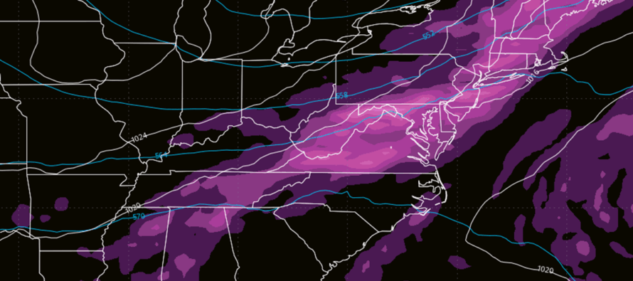
Discussion: The upper levels indicate a sharp transition from ridge to trough for the Mid-Atlantic US and much of the E US. At the lower levels we have two areas of high pressure, one over the ocean near Bermuda and the other tracking across the Great Lakes towards NJ from Canada. The back side of the ocean high is driving the current warmth and humidity via return flow. The Lakes high will provide N flow after the transition. Between the highs will exist an area of convergence capable of producing some much-needed rainfall Tuesday into Wednesday just ahead of the cold front. The rain should push through NJ from Tuesday afternoon through Wednesday morning with the cold front pushing through by Wednesday night. NWNJ should feel the colder air as early as late-Tuesday night/early-Wednesday morning. The rest of NJ should notice the colder air later Wednesday especially after sundown. Rainfall totals are modeled in the half inch to an inch range for all of NJ between Tuesday and Wednesday. We’re warm and humid until Tuesday’s rain spreads into NJ and we’re colder/dryer once the rain tapers off and the cold front comes through by Wednesday afternoon/evening. The weekend is a hard call. We’ll have a strong ridge moving in to keep the coastal low from advancing to the N along the E US coast. Just how far the rain advances N (into NJ or just S of NJ) is yet TBD. It could easily get squashed to the S of NJ as it could make it just into NJ. I will be tracking this closely. No tropical threats to NJ, just another invest (95L) that looks to stay well out to sea once flirting with the Lesser Antilles later this week.
Forecast
Monday (Oct 6) high temperatures should be at their max now (330pm Monday) with many away from the ocean in the 80-85 range with immediate coastal areas held in the 70s. Skies should remain mostly clear. Winds should remain light out of the S/SW as most NJ locations drop to the 55-60 range overnight.
Tuesday (Oct 7) high temperatures should reach a few degrees on either side of 80 depending on if you are close to the ocean or away from such (80-83 away and 75-78 near). Skies should start out mixed with sun and clouds with a slightly humid feel. Clouds should increase and rain should move in during PM hours. Winds should remain light out of the S/SW. Overnight lows should fall to the 60-65 range as rainfall persists into Wednesday morning. Can’t rule out an isolated boomer or two but rain should be main occurrence.
Wednesday (Oct 8) high temperatures should reach near-70 for most NJ locations. Skies and conditions should be transitional starting with overnight rain ending mid-to-late morning and clearing/breezy afternoon-forward. Winds should switch from S/SW to W/NW with the passage of the cold front. Overnight lows could drop into the upper-30s for NNJ elevations but should drop into the 40s for much of NJ. Only SENJ coastal regions should hang closer to 50 as they are last to see the cold front push through. Day and night should feel night and day different 8)
Thursday (Oct 9) high temperatures should reach the 60-65 range for most NJ locations. Skies should be mostly sunny with significantly lower humidity and light N/NE winds…back to the traditional fall feel like last week. Overnight lows should fall to the 35-50 range from NNJ elevations to SNJ coasts—putting much of NWNJ and several areas away from the ocean in frost territory. Much of the state will fall into the lower-40s less the coastal areas hanging closer to 50.
Friday (Oct 10) high temperatures should reach the 60-65 range again. Skies should be mixed with more sun than clouds. Winds should switch to light out of the E. Most of NJ away from the ocean and N should fall to the 40-50 range while coasties stay in the 50-60 range.
An early look at the weekend (Oct 11-12) indicates highs staying in the 60s (lows 45-55) unlike the warmup this past weekend. And that’s mainly due to the N side of an expected coastal storm throwing E winds off the ocean (ocean temps are in 60s). Whether or not rain, from the coastal low, makes it far N enough to fall on NJ is not set in stone just yet. I’ll be monitoring this closely this week as it impacts many outdoor fall plans and festivals – including my own. Have a great week otherwise and please be safe! JC
Premium Services
KABOOM Club offers ad-free content, inside info forecast discussion, your questions answered, and early storm impact maps and video releases (ahead of the public). At two bucks per month, it’s an extremely feasible way to show additional support for Weather NJ. Think of it as a tip jar with perks. Available onFacebook or Patreon.
My Pocket Meteorologist (MPM), in partnership with EPAWA Weather Consulting, offers professional/commercial interests, whose businesses depend on outdoor weather conditions (snow plowing, landscaping, construction, etc.), with hyper-local text message alerts/forecasts and access to the MPM premium forum—the most comprehensive and technical forecast discussion available for PA and NJ.
Jonathan Carr (JC) is the founder and sole operator of Weather NJ, New Jersey’s largest independent weather reporting agency. Since 2010, Jonathan has provided weather safety discussion and forecasting services for New Jersey and surrounding areas through the web and social media. Originally branded as Severe NJ Weather (before 2014), Weather NJ is proud to bring you accurate and responsible forecast discussion ahead of high-stakes weather scenarios that impact this great garden state of ours. All Weather. All New Jersey.™ Be safe! JC


LOCAL FORECAST | INTERACTIVE RADAR | LATEST NJ WEATHER ALERTS | WEDDING FORECAST| PRIVACY POLICY
© Copyright 2025 Weather NJ LLC. All Rights Reserved.
Some information that can be found on our website is provided by a private weather station and is not an officially recognized station for weather reporting. Though we always strive to achieve accurate reporting for our own use, it is important that you do NOT depend on the data provided here for any purpose.
