

Nor’easter a Go
Discussion: A nor’easter is becoming likely this Sunday-Monday, possibly stretching into Tuesday if it stalls long enough. A quick recap for the next few days leading into it…
Another boss cold front has pushed through and cleared the anomalously warm and humid conditions out of New Jersey. Overnight lows tonight should fall into the 40s for most of NJ less coastal regions hanging near or just above 50. Thursday and Friday should max out in the low-to-mid 60s and fall well into the 40s overnight. The coldest point looks like early Friday AM where frost is possible along and N of I-78/NW of I-287. Areas along and N of I-80/NW of I-287 could be looking at a freeze. Both Thursday and Friday look clear and dry. Saturday temps should moderate a bit as onshore flow ensues. Most areas should hit or break 70 on Saturday but under skies increasing in cloudiness. And this, more or less, begins the nor’easter system.
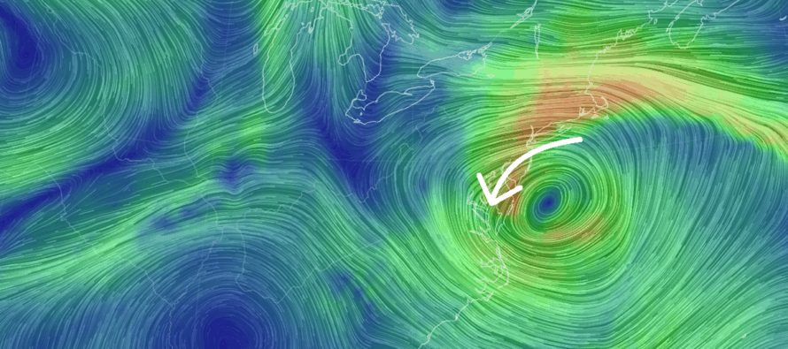
Rainfall should begin somewhere between late Saturday PM and early Sunday AM. It will be arriving out of the S. Onshore winds should build into Sunday daytime hours and crank overnight into and through most of Monday as periods of rain vary in intensity but remain persistent. At some point on Tuesday, conditions should improve. Whether or not that’s Tuesday AM or PM is still yet TBD.
Most models suggest that all of NJ sees at least a half inch to an inch of rainfall from Sunday to Tuesday. Some are suggesting 1-3 inches of rainfall primarily SNJ/SENJ and some of CNJ. This is much needed rainfall. Winds should sustain 20-30mph (gust to 30-40mph) away from the ocean and up into NNJ. Immediate coastal regions should see sustained 25-40mph (gusts to 40-60mph+). The prolonged period of onshore winds that begin Saturday and end between Monday and Tuesday should create a coastal flooding situation that could exceed moderate stage into major stage flooding. That’s the cold hard expectations on paper. Now let’s discuss a few points of reason…
- We’ve seen nor’easters before. We’ve gotten through them. We will get through this one. And we will get through many more in the future.
- Because we haven’t seen one in a while (5+ years), this will feel like a raw and rude awakening.
- There’s a whole new sector of meteorological reporting, especially on YouTube, that uses hyperbole and hyper sensationalism. A lot of this crowd are former network meteorologists on a mission to match or exceed their former salaries and to take down traditional weather news media.
- A lot of news network stakeholders are hungry after a lackluster hurricane season for the E US coast.
- The combination of #2-4 above will likely lead to more fear and negative emotion than we need for a system like this.
- Even though up to 3+ inches of rainfall could happen, it will be over a 48+ hour time frame. It won’t all come in a few hour period like a thunderstorm flash flood. This gives the ground time to absorb and drain away from the ocean. Wind will be less away from the ocean as well. They will still rip, but should be manageable in most cases. Bottom line of this point is that much needed rain and moderate-to-gusty winds are likely away from the ocean and up in NNJ but will be nowhere near the conditions expected along the coast.
Now back to the cold hard expectations which IMO will happen along the coast from NYC down to Cape May and into the Delaware Bay. This is where the coastal flooding and wind combination will sting the most. For these areas, I recommend getting to higher ground (vehicles a concern too) in wind-safe structures and expect wind-related power outages. Gas up the generators, refresh the flashlight batteries, have the candles ready, etc. In the event of an evacuation, listen to the authorities. Otherwise, break out the board games, batten down the hatches and make some soup. It’s going to suck for a few days but again, we’ve seen these many times before.
The anticipated coastal flooding situation will be more from the result of prolonged onshore flow, not so much the intensity of it. A mean area of high pressure is currently responsible for the dry cool down. The S side of this high will team up with the N side of the nor’easter’s cyclonic flow to produce a prolonged nasty fetch of wind off the ocean. Coastal flooding should be the most hazardous element of this storm for ocean-facing coasts, back bays, creeks and estuaries. Wind gusts along the coastal areas should be the second highest hazard of concern. Rainfall is the least concern away from the ocean however along the coast, it will struggle to drain—contributing to the flooding magnitude. Luckily the moon is moving away from its full phase (waning gibbous) that happened a few days ago. Otherwise, a full moon for this would even more concerning for coastal flooding interests.
I’m now in daily article mode for this event and will report accordingly.
In English: The next few days (Thurs and Fri) should be the chilliest conditions yet this fall with clear and dry conditions. Saturday a bit milder but with increasing clouds and onshore winds. A nor’easter then begins late Saturday night/early Sunday morning and wraps up sometime on Tuesday. This means rain, wind and coastal flooding Sunday through Monday and into Tuesday. Starting tomorrow I will really dive into the details of daily expectations. But for now, the nor’easter is a go. Be safe! JC
Premium Services
KABOOM Club offers ad-free content, inside info forecast discussion, your questions answered, and early storm impact maps and video releases (ahead of the public). At $1.99 per month, it’s an extremely feasible way to show additional support for Weather NJ and you can turn it on and off for however many months you wish. Think of it as a tip jar with perks. Available onFacebook or Patreon.
My Pocket Meteorologist (MPM), in partnership with EPAWA Weather Consulting, offers professional/commercial interests, whose businesses depend on outdoor weather conditions (snow plowing, landscaping, construction, etc.), with hyper-local text message alerts/forecasts from real meteorologists and access to the MPM premium forum—the most comprehensive and technical forecast discussion available for PA and NJ.
Jonathan Carr (JC) is the founder and sole operator of Weather NJ, New Jersey’s largest independent weather reporting agency. Since 2010, Jonathan has provided weather safety discussion and forecasting services for New Jersey and surrounding areas through the web and social media. Originally branded as Severe NJ Weather (before 2014), Weather NJ is proud to bring you accurate and responsible forecast discussion ahead of high-stakes weather scenarios that impact this great garden state of ours. All Weather. All New Jersey.™ Be safe! JC


LOCAL FORECAST | INTERACTIVE RADAR | LATEST NJ WEATHER ALERTS | WEDDING FORECAST| PRIVACY POLICY
© Copyright 2025 Weather NJ LLC. All Rights Reserved.
Some information that can be found on our website is provided by a private weather station and is not an officially recognized station for weather reporting. Though we always strive to achieve accurate reporting for our own use, it is important that you do NOT depend on the data provided here for any purpose.
