

Nor’easter Developing

Discussion: A nor’easter is still expected to move in later this weekend and linger through at least Monday, possibly into Tuesday. Before we get to that, expect the coldest night tonight of the current cold stretch. By about 5am tomorrow morning I expect low temperatures to bottom out in the 30s for many areas NW of I-95/NJTP as well as some of the areas just SE of I-95/NJTP in CNJ/SNJ (the sandier soil locations of Salem, NW Gloucester, NW Camden, NW Burlington, and possibly NW Ocean and W Monmouth. The I-95 corridor should stay near or just above 40 due to urban heat island effect and coastal areas the same due to the warmer marine influence of the ocean. We should stay dry through at least Saturday morning with high temps failing to reach 70 on Friday. Saturday we should reach 70 before the nor’easter moves in.
Let’s discuss the synoptics of the expected nor’easter. By early Saturday AM, two upper lows should exist. One tracking from Canada over the Great Lakes. The other forming near Florida. These two upper lows are expected to merge into a single area of cyclonic vorticity by early Tuesday AM somewhere off the coasts between OBX and Delmarva. The 500mb steering currents of these upper lows is what will drive the surface low up the coast, ultimately stalling and retrograding before moving out. The sfc low actually spawns off Miami, FL early Saturday AM, makes it up to OBX by early Sunday AM and then off Cape May/Atlantic City by early Monday AM. From there’s its N movement is stalled by the high over SE Canada/NE US and the low is then expected to retrograde back towards OBX a bit by Tuesday AM before pushing further out to sea by Tuesday PM. It’s a classic upper-level phase and surface capture. The most impressive synoptic feature as of now is the 850mb lower-level jet Monday morning. This is when winds will align of the ocean at about 80mph 5,000 feet above sea level. It will then be up to down drafting from rainfall and/or down drafting from reciprocating adjacent lifting to bring some of those winds down to the surface for New Jersey. Let’s now talk about the surface conditions that everyone will experience, broken down into rain, wind and coastal flooding.
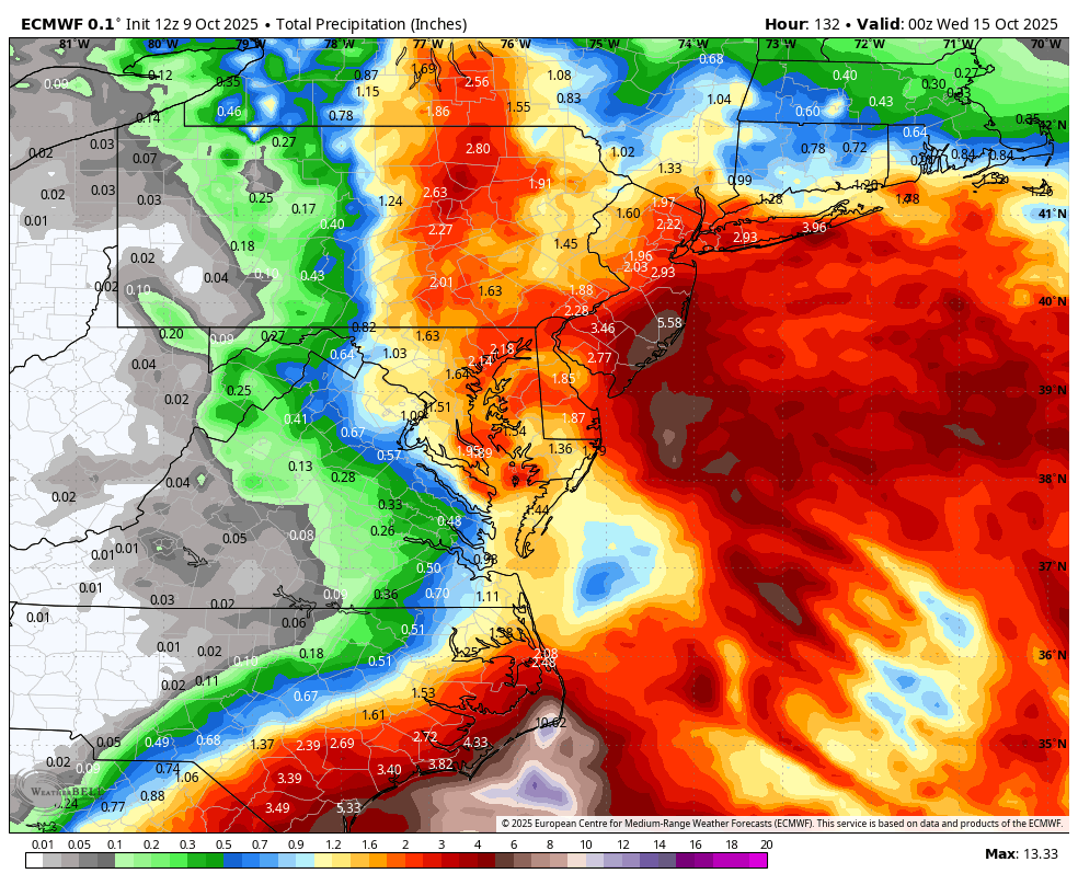
Rain could start in a light misty form as early as Saturday afternoon. The hours of heaviest rainfall, however, should occur between midnight Saturday night and early Tuesday morning—making Sunday and Monday the rainiest days. I’d be surprised to see a 48-hour+ straight deluge of rain though. I suspect we might see a few hours here and there of lulls between heavier batches, especially with the phasing/capture dynamics. Maybe the rain stops during these lulls. Maybe it just backs off to a light misty situation. But overall, this storm should bring solid soakings for 4-6 hours at a time, multiple times, to the region and will greatly benefit the recent developing drought. The general theme, based on storm proximity, location, and angle/origin of approach, is that SENJ should see more rain than NWNJ. My best read of the data indicates between .5 and 1.5 inches for NWNJ, between 1.5 and 2.5 inches for the I-95/NJTP corridor area (SWNJ through CNJ into NENJ) and between 2 and 3 inches for SENJ/coastal regions. It is possible that some coastal SENJ areas exceed 3 inches of total rainfall when all is said and done Tuesday night. Here’s the latest guidance from the Euro for rain through Tuesday night:
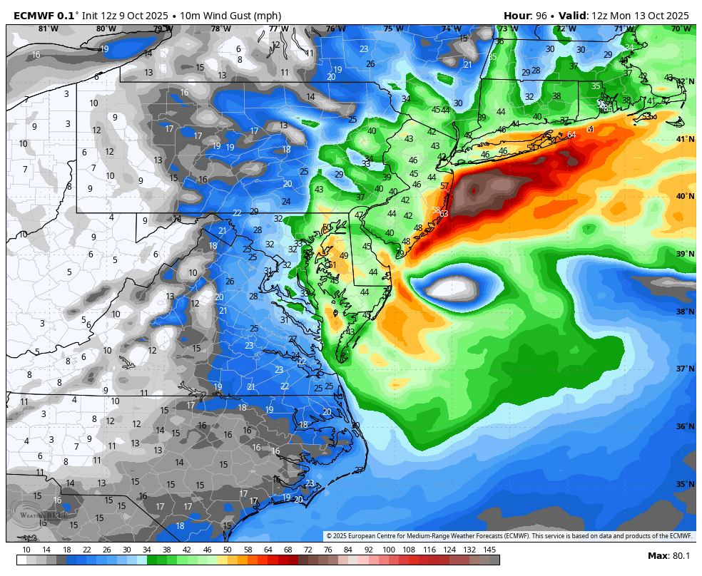
Wind could be a doozy for Halloween decorations and small human beings. The NE US high pressure will kick off the onshore flow as early as Friday (tomorrow) but not too gusty (10-20mph gusts). Winds should then switch to out of the S Friday night into Saturday morning as the high pulls away and hits us with its backside return flow. Winds should then return to an easterly onshore direction and gradually build throughout Saturday (15-25mph felt most along immediate coast) as the N side of the low approaches. Winds should then noticeably build stronger off the ocean later Saturday night into Sunday morning gusting to 25-30mph inland and up 30-40mph along the coast. By Sunday afternoon/evening, winds should be gusting 25-35mph away from the ocean and 40-45mph along the coast. Monday morning looks like the peak of the wind with gusts of 35-45mph away from the ocean and 50-60mph+ along the coast. Winds should then subside from Monday night into Tuesday morning with more of a northerly direction as the low pulls away. I mentioned above in the synoptic discussion that the 850mb (5,000 feet above sea level) lower-level jet will be raging at 80mph around Monday morning. It won’t be 80mph gusts at the surface since winds lose strength with downward propagation. But 40-60mph+ winds are definitely achievable for the surface along the coast. Here’s the peak modeled wind gusts for Monday morning:
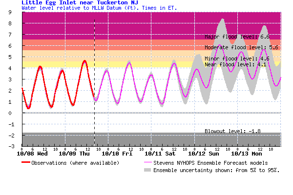
Coastal Flooding potential is concerning. The high tides between Saturday night and Tuesday morning should feature the highest water levels pushed in from the ocean. The Sunday night, Monday morning and Monday night high tides should be the highest water levels of the event with major coastal flooding possible, minor-to-moderate a lock. Here’s the latest tidal flooding guidance from Stevens Flood Advisory System for Little Egg Inlet (most of coast is similar):
In English: The nor’easter has gained confidence in happening. Expect light rain and breeze to start as early as Saturday afternoon, ramping up through Sunday, peaking Monday morning-afternoon, and subsiding Monday night through Tuesday. Inches of rain are possible. Coastal wind gusts of 40-60mph+ are possible. Major coastal flooding is on the table. You should have backup plans for loss of power due to wind-related outages. You should expect downed trees and branches. You should be safely 5-10 feet above ground level if along the immediate coast. A final update will go out tomorrow before live observations begin on Saturday. Have a great rest of your Thursday and please be safe! JC
Premium Services
KABOOM Club offers ad-free content, inside info forecast discussion, your questions answered, and early storm impact maps and video releases (ahead of the public). At $1.99 per month, it’s an extremely feasible way to show additional support for Weather NJ and you can turn it on and off for however many months you wish. Think of it as a tip jar with perks. Available onFacebook or Patreon.
My Pocket Meteorologist (MPM), in partnership with EPAWA Weather Consulting, offers professional/commercial interests, whose businesses depend on outdoor weather conditions (snow plowing, landscaping, construction, etc.), with hyper-local text message alerts/forecasts from real meteorologists and access to the MPM premium forum—the most comprehensive and technical forecast discussion available for PA and NJ.
Jonathan Carr (JC) is the founder and sole operator of Weather NJ, New Jersey’s largest independent weather reporting agency. Since 2010, Jonathan has provided weather safety discussion and forecasting services for New Jersey and surrounding areas through the web and social media. Originally branded as Severe NJ Weather (before 2014), Weather NJ is proud to bring you accurate and responsible forecast discussion ahead of high-stakes weather scenarios that impact this great garden state of ours. All Weather. All New Jersey.™ Be safe! JC


LOCAL FORECAST | INTERACTIVE RADAR | LATEST NJ WEATHER ALERTS | WEDDING FORECAST| PRIVACY POLICY
© Copyright 2026 Weather NJ LLC. All Rights Reserved.
Some information that can be found on our website is provided by a private weather station and is not an officially recognized station for weather reporting. Though we always strive to achieve accurate reporting for our own use, it is important that you do NOT depend on the data provided here for any purpose.
