

A Hard Slap of Fall Feel
Discussion: Our rainstorm has ended regarding precipitation. All of NJ saw at least the .75 inch expectation. Much of WNJ just reached that. Parts of ENJ, especially NENJ, exceeded the 2 inch mark with some localized areas seeing between 2.5 and 3 inches of rainfall. Much needed! Unfortunately, this timed poorly with a brief period of onshore flow near high tide yesterday which put a few coastal regions into moderate stage coastal flooding. This, like the rainfall, is now over and offshore winds will help to drain the tide tables moving forward.
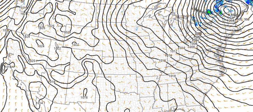
Now we deal with the wind. As I mentioned this week in articles leading to the event, this is the kind of storm where the strongest winds occur afterwards, not during. Some NJ locations did see gusts in the 35-45mph range yesterday when winds were out of the S/SE, especially coastal regions. But now that the cold front is through, we’re going to see the strongest winds out of the W/NW of NW. It took some time for a few areas of low pressure to consolidate and zip up the occlusion that ran through the cold and warm fronts last night/this morning across the Mid-Atlantic US. This is the reason why winds became somewhat tranquil (the lull) between rain ending yesterday afternoon/evening and earlier this morning. But now we have a singular 982mb (and dropping) low over the NE US which has taken over regionally (might as well call it most of the E US). See the above cover image.
The tight isobars, aligned for a W/NW wind direction, tell me that winds are going to continue picking up and blow stiff for the remainder of today and into tomorrow morning. Temperatures and humidity will also continue to drop as the entire region dries and chills. It’s going to be a cold and windy Halloween for trick-or-treating but as tracked and promised, it will be dry this evening. Please dress accordingly.
Winds should subside by late-Saturday morning and the rest of the weekend looks rain-free. High temps for Saturday and Sunday will likely max in the 50s statewide. Coastal regions will fall to the 40s overnight and areas away from the ocean and up into NNJ/WCNJ will fall into the 30s. I think most inland areas stay above freezing unless NWNJ elevations make a run for 32 or slightly below. This system has now kicked fall into another gear as highs in the 50s will become more common for early November.
The next synoptic storm signal I’m tracking is around ~November 4th as a N and S stream of energy tries to couple. From this range, it looks wet not wintry but you never know for elevations this time of year. Likely too warm for any sort of stickage though.
In English: Look, I have nothing against tiny people. I do not make fun of people for their height. When I say “secure small human beings” I am genuinely concerned for their safety that they do not fly away. With that said, tonight is one of those nights and there will be many tiny people walking around collecting candy. Please make sure your children are dressed for a cold and windy night. It won’t rain though. Winds should blow stiff this evening, overnight and into Saturday morning. They should subside by late-Saturday morning. The rest of the weekend looks dry and colder. You will likely notice more of late fall look as many areas are now past peak foliage with a lot of leaves blown off the trees. Onward we go as Winter 2025-2026 closer approaches. Tracking the next rainstorm around Nov 4th. Have a great weekend, Happy Halloween and please be safe! JC
Premium Services
KABOOM Club offers ad-free content, inside info forecast discussion, your questions answered, and early storm impact maps and video releases (ahead of the public). At $1.99 per month, it’s an extremely feasible way to show additional support for Weather NJ and you can turn it on and off for however many months you wish. Think of it as a tip jar with perks. Available onFacebook or Patreon.
My Pocket Meteorologist (MPM), in partnership with EPAWA Weather Consulting, offers professional/commercial interests, whose businesses depend on outdoor weather conditions (snow plowing, landscaping, construction, etc.), with hyper-local text message alerts/forecasts from real meteorologists and access to the MPM premium forum—the most comprehensive and technical forecast discussion available for PA and NJ.
Jonathan Carr (JC) is the founder and sole operator of Weather NJ, New Jersey’s largest independent weather reporting agency. Since 2010, Jonathan has provided weather safety discussion and forecasting services for New Jersey and surrounding areas through the web and social media. Originally branded as Severe NJ Weather (before 2014), Weather NJ is proud to bring you accurate and responsible forecast discussion ahead of high-stakes weather scenarios that impact this great garden state of ours. All Weather. All New Jersey.™ Be safe! JC


LOCAL FORECAST | INTERACTIVE RADAR | LATEST NJ WEATHER ALERTS | WEDDING FORECAST| PRIVACY POLICY
© Copyright 2026 Weather NJ LLC. All Rights Reserved.
Some information that can be found on our website is provided by a private weather station and is not an officially recognized station for weather reporting. Though we always strive to achieve accurate reporting for our own use, it is important that you do NOT depend on the data provided here for any purpose.
