

Weekend Snow a Go!
Discussion: Real quick, we’ll drop to a range of about 15-25 tonight from NNJ elevations to SNJ coasts under mixed skies. Saturday will likely reach into the 40s for much of the coastal plain for daytime highs. Temperatures will then fall Saturday evening after sundown, to freezing or below along and NW of I-95 and to the mid-to-upper 30s SE of I-95. Precipitation will arrive late Saturday night (by midnight) as snow blankets New Jersey. Instant stickage along and NW of I-95 and a few hour period for SENJ where the surface drops to the point of stickage. Will happen last for Cape May-Atlantic City areas. Then all snow through the rest of Sunday morning ending by 10am NW to SE. Some wildcards…
The coastal plain will be subjected to SW flow on Saturday. A few days ago, the daytime temperatures were modeled a little colder because of an anticipated flow closer to W/SW. But now the more SW direction will bring in a warmer low layer later for Saturday. This is a good thing for the snow lover in New Jersey. It means the thermal gradient boundary is a little more tilted, likely in response from upstream ridge amplification. This tends to produce stronger lows which further allows for the weak fadeaway coastal sfc low, that will be forming off Delmarva/OBX, to possibly hit 1008 instead of 1012 (just throwing number example). Also, the low will be crossing over the very warm gulf stream which can temporarily enhance low pressure drop. This would then mean higher snowfall rates for longer since low intensification slows its track speed. These minor meteorological differences can have solid impacts on snow accumulations, especially across New Jersey snow events.
There’s also a raging jet streak running W/SW to E/NE over NJ during this system. If this gets more involved as a venting mechanism, then it could enhance frontogenic forcing and cause convective banding (linear stripes on radar representing best lifting air vs adjacent sinking air). Banding and/or thundersnow are good indicators that it’s happening. I believe it was Jim Cantore who said something along the lines of, “if you hear thundersnow, add 3-6 inches to expected totals.” This would be another wildcard that could bring people to the max or greater of their snow map zones below.
While the warmer low intensification and jet streak convective enhancements are positive wildcards, there are also negative wild cards. If the upstream Arctic high alters the jet too meridionally and pulls the entire thermal gradient to the NW, then areas SE of 95 would be too warm for stickage and snow in New Jersey places. There’s no modal currently showing this, only a short period where SENJ delays stickage for a few hours. There is a wave transfer across PA before the system starts for NJ. If that transfer were to happen earlier or later it could create a dry slot in the wrong place, possibly over Jersey. Nothing shows this either but I’ve seen it happen in rare cases. If the cold suppression from the N were to lower the storm axis, then SNJ would only see the plowable stuff with NNJ and much of CNJ getting robbed. These are wildcards in both directions. I will say though that the data consensus in general has been very consistent all week, despite its process in honing in on a more specific solution. There’s been nonstop jackpot axis over either NNJ/CNJ/SNJ for over 98 hours and it’s very locked in right now as we’re inside the 24-36 hour away period. It’s hard for me to see either negative wildcard hitting 100%. A step to in either direction would be a more down to Earth expectation. But if both enhancement wildcards were to hit, we could be looking at more of a doozy here.
With all of that said, we have to make a call. A Euro/RGEM blend drove our first call snow map for this event as well as a deep dive into some of the soundings. The coastal plain (along and SE of I-95) will take some time to cool Saturday night but I don’t think much rain is in the cards initially there. The lower amounts in extreme SNJ/SENJ will likely be due to snow falling and melting, not from rain. Again, it’s only the lower-level and sfc that will be a few degrees above freezing during initial precipitation. The precip will bring the surface temps down SE of I-95 via evaporational cooling and stickage should begin within a few hours tops. But that would take a slight toll on final accumulations hence our southern zone D.. For this and other reasons, here’s our first call snow map for Sunday’s expected snowfall specifically in New Jersey.
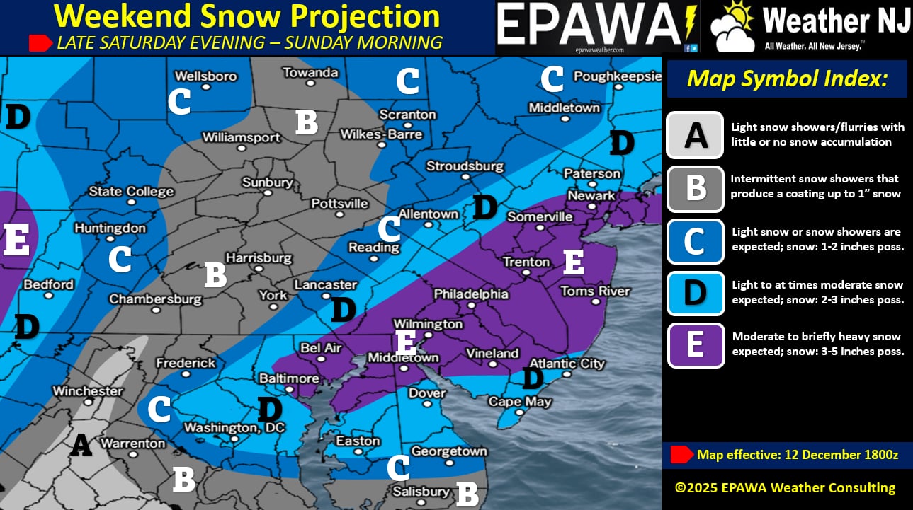
In English: Statewide snow is expected in New Jersey between late Saturday night and mid-to-late Sunday morning (starting by midnight Saturday night ending by 10am Sunday morning give or take). Our snow map above illustrates our first call on expected accumulation amounts. Most will wake up to snow on the ground. Sunday night-Monday will be very cold with wind chills as Arctic air spills in from the NW over the freshly accumulated snow in New Jersey. Sunday evening is a great time for a holiday lights hot chocolate cruise if you’re into that sort of thing. By then most roads should be plowed/treated but the snow will stay put. If you do head out, take it slow, especially over any untreated/icy/slushy areas. Have a great rest of your Friday and please be safe! JC
Premium Services
KABOOM Club offers ad-free content, inside info forecast discussion, your questions answered, and early storm impact maps and video releases (ahead of the public). At $1.99 per month, it’s an extremely feasible way to show additional support for Weather NJ and you can turn it on and off for however many months you wish. Think of it as a tip jar with perks. Available onFacebook or Patreon.
My Pocket Meteorologist (MPM), in partnership with EPAWA Weather Consulting, offers professional/commercial interests, whose businesses depend on outdoor weather conditions (snow plowing, landscaping, construction, etc.), with hyper-local text message alerts/forecasts from real meteorologists and access to the MPM premium forum—the most comprehensive and technical forecast discussion available for PA and NJ.
KABOOM Shop is live if you want some KABOOM or Weather NJ Merch!
Jonathan Carr (JC) is the founder and sole operator of Weather NJ, New Jersey’s largest independent weather reporting agency. Since 2010, Jonathan has provided weather safety discussion and forecasting services for New Jersey and surrounding areas through the web and social media. Originally branded as Severe NJ Weather (before 2014), Weather NJ is proud to bring you accurate and responsible forecast discussion ahead of high-stakes weather scenarios that impact this great garden state of ours. All Weather. All New Jersey.™ Be safe! JC


LOCAL FORECAST | INTERACTIVE RADAR | LATEST NJ WEATHER ALERTS | WEDDING FORECAST| PRIVACY POLICY
© Copyright 2026 Weather NJ LLC. All Rights Reserved.
Some information that can be found on our website is provided by a private weather station and is not an officially recognized station for weather reporting. Though we always strive to achieve accurate reporting for our own use, it is important that you do NOT depend on the data provided here for any purpose.
