

Winter Storm Detected!
Discussion: The jet stream pattern, dictating the thermal gradient boundary (boundary) remains in a configuration of blowing across S Canada W to E, dipping down over the E Great Lakes and running through the Mid-Atlantic US. This will keep those to the S and W of this boundary warm and those to the N and W of it cold enough for wintry weather. Synoptic features will push this boundary to the NE and SW as warm fronts and cold fronts.
Later this week, high pressure will drift across S Canada from W to E (just to the N of the boundary). This high will ultimately push the boundary to the SW so that it runs somewhere through SNJ/CNJ. Current data suggests this being near a line drawn from Philly to Toms River. If the high is stronger, it would push the boundary to a line drawn from Wilmington, DE to Cape May. If the high is weaker it will push the boundary to a line drawn from Trenton to Monmouth. It’s all going to come down to the high’s strength. Once that is established, another wave will traverse the boundary and deliver snow to the NE of it, ice right along it, and rain to the SW of it this Friday PM (Dec 26) into early Saturday AM (Dec 27).
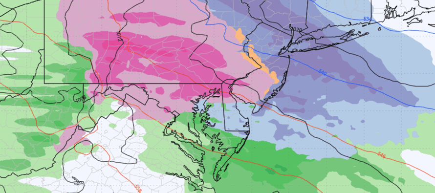
Over the past few days, the GFS has had the strongest modeled high and therefore has been the coldest and snowiest. The Canadian has had the weakest high and therefore is the iciest/rainiest for the entire state outside of extreme NENJ. The Euro (precip types indicated in above article cover image) is splitting the difference with snow for NNJ and a wintry mix for SNJ. We’re not even into the range of looking at short-range data yet so still some time to go. We are still a ways from any kind of wintry or snow impact map. I do, however, think most of NJ can start to expect a decent-impact winter storm this Friday-Saturday regardless of wintry precipitation type (snow vs sleet vs freezing rain). Bergen County stands the best chance for all snow. Salem County stands the best chance for a wintry mix ending as rain. Quite the battleground between with the snow/ice/rain lines falling perpendicular to the I-95 corridor somewhere across CNJ/SNJ. That’s how it looks for now.
From this range, the data suggests a 5pm Friday (Dec 26) to 5am Saturday (Dec 27) general timing of precipitation, regardless of type. The heaviest rates of precipitation would likely fall in the 8pm to 3am portion of that overall time window.
In English: Christmas Eve and Day look mild. We get colder Thursday night, warm up again Friday during the day but then fall into Friday night as likely a mix of snow, sleet, freezing rain, and rain push across NJ between 5pm Friday night and 5am Saturday morning. As of now, this looks colder and more wintry for more of NJ than what we just had this morning. Wintry precipitation in one form or another is gaining confidence. Who will see all and only snow however is of low confidence at this point. More to come. Have a great rest of your Tuesday and please be safe! JC
Premium Services
KABOOM Club offers an ad-free environment, inside info (Above and Beyond) forecast discussion, your questions prioritized, and early storm impact maps and video releases (ahead of the public). At $1.99 per month, it’s an extremely feasible way to show additional support for Weather NJ and you can turn it on and off for however many months you wish. Think of it as a tip jar with perks. Available onFacebook or Patreon.
My Pocket Meteorologist (MPM), in partnership with EPAWA Weather Consulting, offers professional/commercial interests, whose businesses depend on outdoor weather conditions (snow plowing, landscaping, construction, etc.), with hyper-local text message alerts/forecasts from real meteorologists and access to the MPM premium forum—the most comprehensive and technical forecast discussion available for PA and NJ commercial interests.
KABOOM Shop is live if you want some KABOOM or Weather NJ Merch!
Sign up for ZoneWatch Radar and get 10% off
Jonathan Carr (JC) is the founder and sole operator of Weather NJ, New Jersey’s largest independent weather reporting agency. Since 2010, Jonathan has provided weather safety discussion and forecasting services for New Jersey and surrounding areas through the web and social media. Originally branded as Severe NJ Weather (before 2014), Weather NJ is proud to bring you accurate and responsible forecast discussion ahead of high-stakes weather scenarios that impact this great garden state of ours. All Weather. All New Jersey.™ Be safe! JC


LOCAL FORECAST | INTERACTIVE RADAR | LATEST NJ WEATHER ALERTS | WEDDING FORECAST| PRIVACY POLICY
© Copyright 2026 Weather NJ LLC. All Rights Reserved.
Some information that can be found on our website is provided by a private weather station and is not an officially recognized station for weather reporting. Though we always strive to achieve accurate reporting for our own use, it is important that you do NOT depend on the data provided here for any purpose.
