

Friday-Saturday Winter Storm Update
Discussion: Last night and early this morning, the data jumped warmer but has since returned to what we feel is reality today. We do not think the NAM is correct in its handling of geopotential height fields across the Mid-Atlantic US. But even the NAM has come back to a colder solution as of 12z data today. The GFS is actually reflecting live observations vs model initialization best and the GFS ensembles have even more so confirmed this. A refresher summary about this system: It’s an overrunning wave along a thermal gradient boundary running NW to SE. That means that the snow/ice/rain line separators will run untraditionally NW to SE instead of SW to NE. This puts places like Bergen County, NYC and even Monmouth County in a colder position than WCNJ up into Hunterdon County. It’s just the pattern we’re in.
The temperature profile for this system leans colder than warmer for a few reasons: 1) Precipitation will occur overnight when temps are coldest within the traditional 24-hour period of the day. 2) There is high pressure to the N/NE of the low pumping colder air in from the NE at the surface/lower levels. 3) Everything this year has verified a little colder than what has been modeled due to the data not correctly handling the larger global forces at play (polar vortex influence, weak La Nina, -QBO, MJO, etc.). When looking at the traditional layers that models typically kick out (SFC, 925mb, 850mb, 700mb), all layers are below freezing from the snowmaking altitude down to the surface. What you don’t see on model sites are the adiabatic soundings that can indicate where a warm layer can stick its nose. In this case we see this layer being very shallow at about the 800mb layer. This is the layer that the low will hoist over the boundary as far NE as a line drawn from Allentown, PA to about Brick, NJ, possibly even NE of that. This is the shallow layer that would melt snowflakes into droplets that refreeze at the lower levels before hitting the ground as ice (sleet pellets). The layers below that are cold from the high driving colder air in from the NE.
That said, this winter storm is expected to be a snow and sleet storm for much of NJ, not an all snowstorm and not a snow/rainstorm. As far as how much snow changes over to sleet will be determined by how far NE the warm layer sticks its nose in from the SW and how thick that layer is. I’ve seen a few of these systems over time and experience where the high pressure simply puts a “thou shall not pass” cold wall up and keeps more people all snow. I don’t think that’s the case for all of NJ here, especially SWNJ/SNJ, but it could very well be for the northern 2/3 to 1/2 of NJ given the axis of the NW to SE boundary. The warm layer could only advance to about the AC Expressway and/or it might collapse within the cold above and below it.
Things could also verify warmer with the warm layer advancing all the way into NNJ. The models last night/early this morning suggested this but the fact that they are already coming back colder today tells me that no one should be jumping ship to the NW of the Atlantic City Expressway and especially not N of I-195. Timing has not changed. We still expect this to occur between the overall 5pm to 5am hours with heaviest rates between 7pm and 3am (Friday into Saturday). That said, here’s our updated snow map for the incoming winter storm of snow and ice. Additionally, a graphic of two scenarios which I speak to in the In English section below.
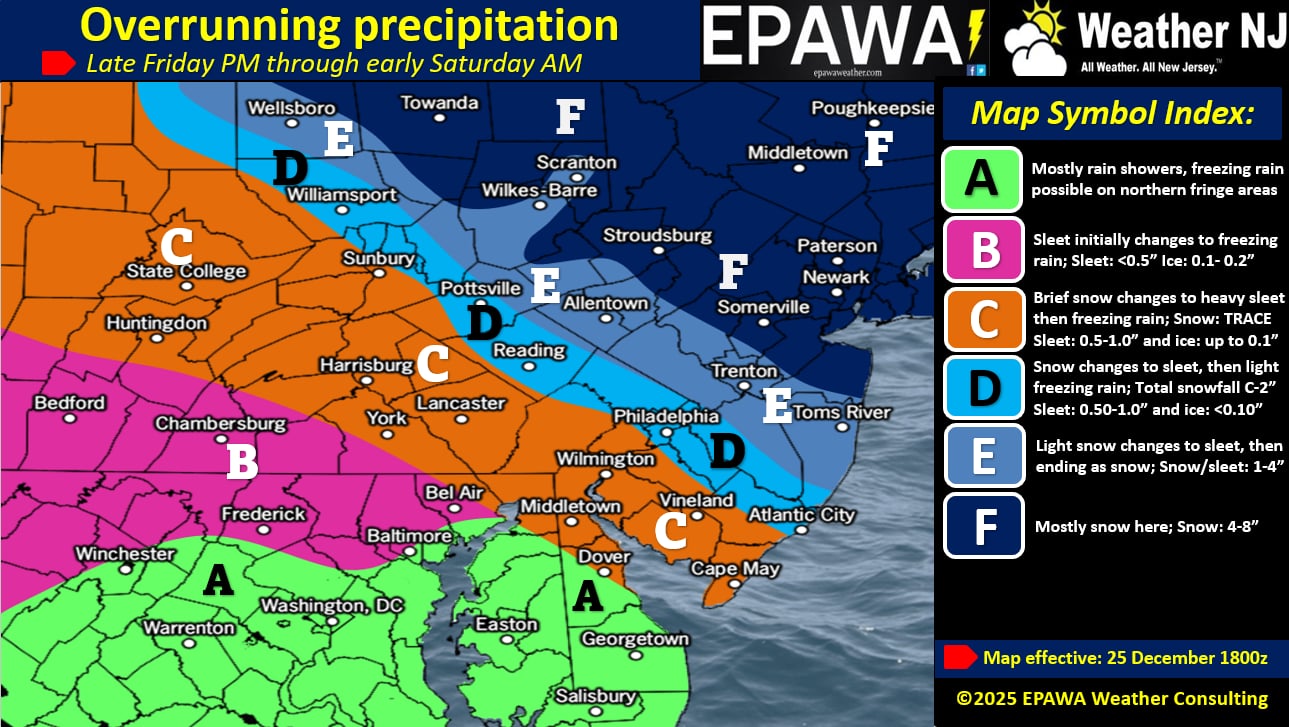
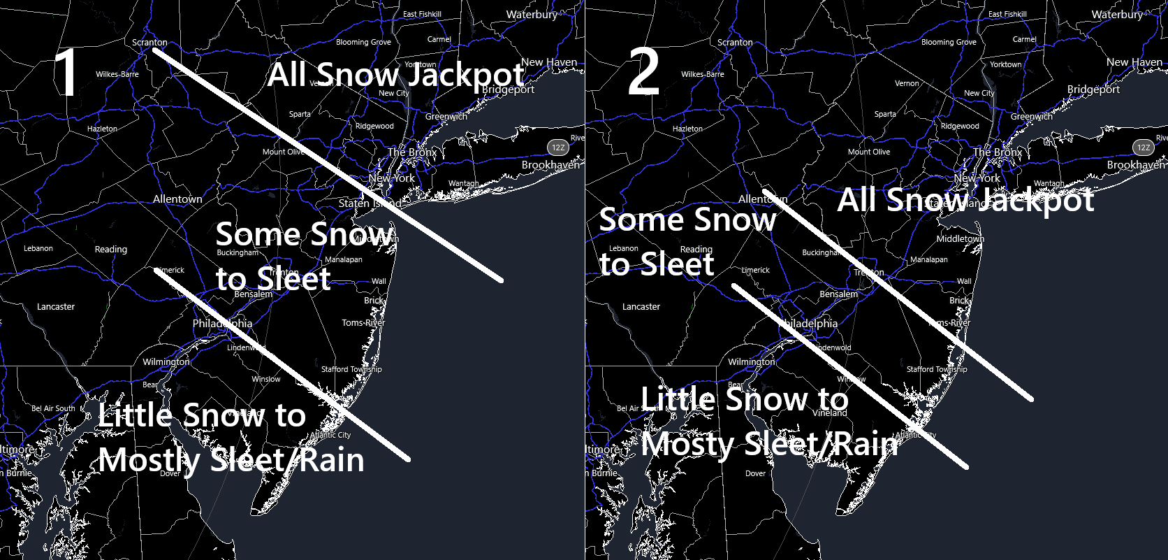
In English: The winter storm is still on and for many in NJ, a snow to sleet storm. Models trended warmer overnight but have ticked back colder today. We think SWNJ and parts of SNJ are likely hosed with more sleet (possibly some rain in extreme SNJ) than snow. We think it’s going to thump in NENJ and most of NNJ. The battleground between remains and will be determined by how much snow changes to sleet based on the processes I mentioned in the above discussion. Notice our zones D and E in the updated map above actually overlap a bit. We hate doing this. We normally don’t but with a thermal gradient this uncertain, we feel its warranted. We still have room tomorrow morning for a final update if needed. We don’t want to go “down with the ship” on a final call today for a system over 24 hours away from starting. Some outlets do that with nothing held back. It’s admirable, but mistaken. And it’s helpful to no one if there are large trends overnight tonight. But it just might be a three-map system for us to feel ok. I’ve attached an additional graphic illustrating two scenarios. Actual verification should fall somewhere between these two scenarios. Our map is closer to 1 however my gut wants to lean towards 2 for the reasons stated above in the second paragraph. If 2 happens then the colder wildcard would be realized as more of an all snow situation for NNJ and ECNJ…you would have to bump everything up a few inches with the exception of maybe zone C. Have a very merry rest of your Christmas Day and please be safe! JC
Premium Services
KABOOM Club offers an ad-free environment, inside info (Above and Beyond) forecast discussion, your questions prioritized, and early storm impact maps and video releases (ahead of the public). At $1.99 per month, it’s an extremely feasible way to show additional support for Weather NJ and you can turn it on and off for however many months you wish. Think of it as a tip jar with perks. Available onFacebook or Patreon.
My Pocket Meteorologist (MPM), in partnership with EPAWA Weather Consulting, offers professional/commercial interests, whose businesses depend on outdoor weather conditions (snow plowing, landscaping, construction, etc.), with hyper-local text message alerts/forecasts from real meteorologists and access to the MPM premium forum—the most comprehensive and technical forecast discussion available for PA and NJ commercial interests.
KABOOM Shop is live if you want some KABOOM or Weather NJ Merch!
Sign up for ZoneWatch Radar and get 10% off
Jonathan Carr (JC) is the founder and sole operator of Weather NJ, New Jersey’s largest independent weather reporting agency. Since 2010, Jonathan has provided weather safety discussion and forecasting services for New Jersey and surrounding areas through the web and social media. Originally branded as Severe NJ Weather (before 2014), Weather NJ is proud to bring you accurate and responsible forecast discussion ahead of high-stakes weather scenarios that impact this great garden state of ours. All Weather. All New Jersey.™ Be safe! JC


LOCAL FORECAST | INTERACTIVE RADAR | LATEST NJ WEATHER ALERTS | WEDDING FORECAST| PRIVACY POLICY
© Copyright 2026 Weather NJ LLC. All Rights Reserved.
Some information that can be found on our website is provided by a private weather station and is not an officially recognized station for weather reporting. Though we always strive to achieve accurate reporting for our own use, it is important that you do NOT depend on the data provided here for any purpose.
