

Weekend Snow Update
Discussion: There are two snow chances for snow this weekend, Saturday and Sunday and they are connected. Neither event is currently looking like a major snowstorm. These two snow possibilities are going to be the last salvageable snow from the general Jan 15-20 period that we’ve been watching closely due to deep troughs and powerful upper-level dynamics well-advertised almost two weeks in advance. This can also serve as proof that even though you have a good-looking pattern, capable of supporting snowstorms, in the upper levels, it still all has to come together to produce a snowstorm at the surface.
The way that Saturday and Sunday are connected is how Saturday’s snow influences Sunday’s snow. We have a very progressive trough with a positive tilt involved. Once Saturday comes in and out, it will set a steering current behind it for Sunday’s system. If Saturday is weaker (just flurries) then it will not push the boundary behind it too far S. This will allow Sunday to come closer to NJ and bring more snow to NJ. However, if Saturday is stronger then the boundary will be pushed further S and E behind it and will keep Sunday’s coastal system offshore outside of maybe flurries for extreme SENJ. So, the way this is starting to work out, you can have snow Saturday or Sunday but not both. And it is simply too early to make a call either way at this point.
Models are all over the place. Yesterday’s hitting GFS is offshore today and yesterday’s offshore Canadian is a hit today. The Euro has trended closer to the coast for Sunday but now is advertising the strongest snowfall on Saturday rather than Sunday…on the old Euro at least. However, the new Euro AI is a hit much further into NJ on Sunday. There is nowhere near the consistency and consensus needed today to make a call on either system. The most confident statement I can make today is that snow is possible on either day and hopefully tomorrow, we will know which piece (Saturday or Sunday) has the better chance to produce snow this weekend.
The maximum upside potential can be anticipated for both but is not a forecast. If all energy goes into Saturday, NJ could see a statewide C-2”/1-3” scenario with little-to-nothing for SENJ. If Saturday is weak with just flurries, then Sunday’s snow would target the SENJ coast with a maximum upside potential for 3-6” Cape May to Monmouth and then a sharp cut-off as you head W towards Philly or NW of I-95.
The weather models have been atrocious this year vs prior years. I refuse to get political, but this year there have been direct funding cuts to a lot of NOAA/NWS data collection/sensor areas across the US. This data feeds the models so that the models can compare current observed data against the past 30-year climatological period to see what the most probable future outcome is based on comparisons of the past. That’s how models work and meteorologists and forecasters rely heavily on this data output to compare with live observations and make forecast decisions. Imagine taking 25-40% of auto mechanic tools away. Job performance is going to suffer. This is something I am going to visit in much further detail in a near-future article. Once again, it will not be political. I would say this about any administration who made such funding cuts to NOAA regardless of party But I can tell you that the data has become worse this year than prior years. Not blaming anything as it is us who ultimately makes a call based on the data. But it is worth mentioning at this point since you can all see the degradation in front of your own eyes now.
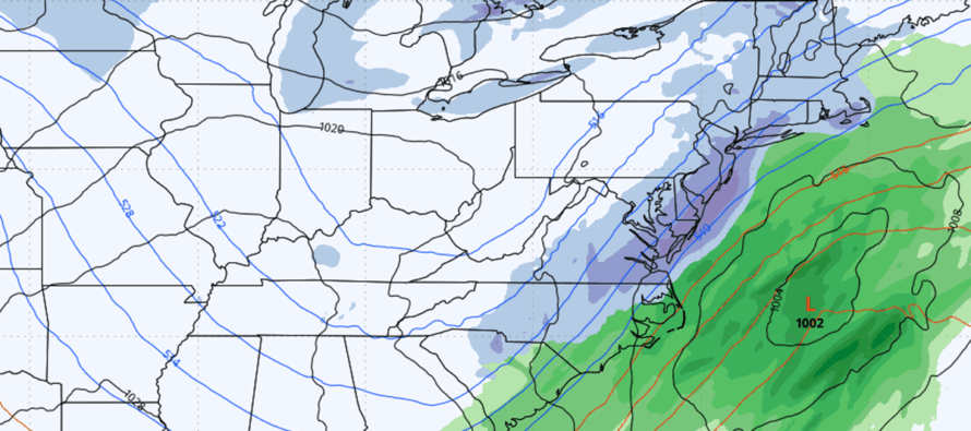
In English: Cold has returned and snow is possible this weekend both Saturday and Sunday. Neither is a big snow system, but it is more likely that one of the days happens and the other does not since they are connected and dependent on each other. The data is too inconclusive to roll with a forecast today. We hope that the data arrives at more of a consensus by tomorrow to put out a snow map. There are some details in the above discussion about what could possibly happen in the snowiest outcome possible but again, it’s all going to depend on which day the storm energy focuses on, Saturday or Sunday. If Saturday comes to fruition, the timing would be about 10am to 6pm. If Sunday comes into fruition, the timing would be 10am Sunday to 2am Monday. The cover image above is from the latest RGEM run just as one possible outcome. This solution is also currently supported by the NAM, Canadian, AI GFS and AI Euro from today’s 12z data suite.
A note about yesterday’s post with yesterday’s 12z GFS image. I will repeat it here:
“While the first signal of the heavily-tracked Jan 15-20 period did not come to fruition, the second signal for Sunday is showing signs of life. Article coming this afternoon with detailed synopsis but here’s what the GFS just laid out at 12z today. Be safe! JC”
Everything I said was true and still is today except for posting an article. I am sorry I did not get to post an article yesterday. Personal life schedule just didn’t allow it. I’m in the middle of a busy primary career work week, prepping an extensive birthday dinner for Saturday, and of course tracking the models for weekend snow. But I do want to address some of the comments I saw on the post. First, to those who understand who I am, what I represent and how I forecast, thank you for your continued support! But to those of you doing drive-by negative/personal/insult comments, shame on you! It became clear that some of you cannot handle when models show snow…and even though we scream “this is not a forecast/this is model output” some of you simply do not “get it.” Today, in 2026, there are comprehensive AI bot farms that actually interact back and forth as indistinguishable people with realistic looking profiles and histories. I suspect some of the comments were likely from such AI bots. Other real people just seem so insufferable that they have to spread the negativity from their soul outwards without self control. Again, shame on those people! Negative comments that lash out personally will be deleted and your account will be banned from Weather NJ going forward. Won’t even give it a second thought. Instaban. Have a great rest of your Thursday and please be safe! JC
Premium Services
KABOOM Club offers an ad-free environment, inside info (Above and Beyond) forecast discussion, your questions prioritized, and early storm impact maps and video releases (ahead of the public). At $1.99 per month, it’s an extremely feasible way to show additional support for Weather NJ and you can turn it on and off for however many months you wish. Think of it as a tip jar with perks. Available onFacebook or Patreon.
My Pocket Meteorologist (MPM), in partnership with EPAWA Weather Consulting, offers professional/commercial interests, whose businesses depend on outdoor weather conditions (snow plowing, landscaping, construction, etc.), with hyper-local text message alerts/forecasts from real meteorologists and access to the MPM premium forum—the most comprehensive and technical forecast discussion available for PA and NJ commercial interests.
KABOOM Shop is live if you want some KABOOM or Weather NJ Merch!
Sign up for ZoneWatch Radar and get 10% off
Jonathan Carr (JC) is the founder and sole operator of Weather NJ, New Jersey’s largest independent weather reporting agency. Since 2010, Jonathan has provided weather safety discussion and forecasting services for New Jersey and surrounding areas through the web and social media. Originally branded as Severe NJ Weather (before 2014), Weather NJ is proud to bring you accurate and responsible forecast discussion ahead of high-stakes weather scenarios that impact this great garden state of ours. All Weather. All New Jersey.™ Be safe! JC


LOCAL FORECAST | INTERACTIVE RADAR | LATEST NJ WEATHER ALERTS | WEDDING FORECAST| PRIVACY POLICY
© Copyright 2026 Weather NJ LLC. All Rights Reserved.
Some information that can be found on our website is provided by a private weather station and is not an officially recognized station for weather reporting. Though we always strive to achieve accurate reporting for our own use, it is important that you do NOT depend on the data provided here for any purpose.
