

Weekend NJ Snowstorm Chances Gaining Slight Confidence

Discussion: The weekend coastal snowstorm chances are gaining slight confidence. But before we dive in, I have a point to address.
This is about the time when everyone tells me, “hey JC my app says this and my app says that.” “Channel whatever news says out to sea miss.” Let me address this now. Automated weather apps pull surface output only from usually a single model. Since that changes every 6 hours with each model quite/run, so does the app. What you see is likely a data feed from the National Blend of Models or possibly just the GFS. Do automated weather apps get it right sometimes? Yeah, sure and I use them sometimes. Example: If I am packing up the car to take the family to the beach, and it’s a clear blue sky day, I might look to see how hot and humid it will be so I don’t have to do model analysis when we are rushing lol. Automated apps are much more accurate during settled weather conditions. However, during unsettled higher-stakes events like this past weekend or this upcoming weekend, human analysis of multiple models (upper level physics not just surface output) is king. And unfortunately, a lot of broadcast meteorologists even weather outlets simply regurgitate surface model output while failing to communicate why this is happening from an upper level view. Here at Weather NJ, you will always get the detailed upper-level synoptic analysis that governs the surface output. They do have flashy graphics though. I’ll give them that. So, from this point on, please forgive me for focusing on my own forecast while not commenting on other specific forecasts, whether made by an automated app or a dude in a suit with an over-the-top radio voice inflection 8). Thank you! So, let’s dive in.
In my opinion, there is remarkable consensus that there will be a powerful storm in the ocean. This is one of the reasons why I believe that the weekend NJ snowstorm chances are gaining slight confidence. Additionally, the cluster of modeled low track and storm location is remarkably tight from this range (4.5 days away). Overnight and today’s data guidance so far has ticked a little NW. It still does not bring statewide heavy snow to all of New Jersey but it’s bringing heavy snow to at least the I-95/NJTP corridor and significant snow slightly NW of the I-95/NJTP corridor. This is all because at the upper levels, the models are seeing a better interaction between the main trough and southern stream of energy involved. Specifically, the southern stream is faster and deeper across the Texas area which allows more of it to wrap into the main trough and bomb out the low off our coast. The GFS and Canadian has the best looking upper-level interactions. The Euro was improved but still has way to go. And yes, we are talking about the meteorological term called bombogenesis where a coastal surface low’s central pressure drops more than 24mb in a 24 hour period or less. You’ll probably see the “HOLY BOMB CYCLONE BATMAN” posts from the others lol.
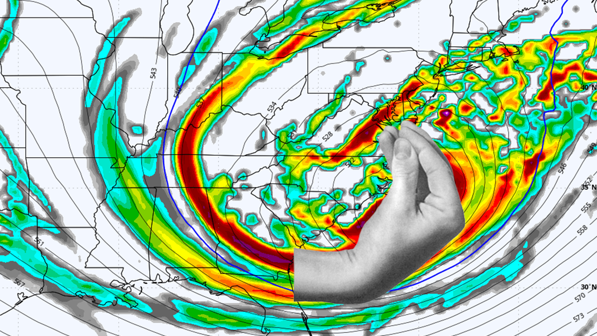
It cannot be overstated, however, that this will be a complex system of many moving parts that has to thread the needle in short timing to produce a major NJ snowstorm. As many of us found out in the January blizzard bust of 2015 (named Juno by TWC), you can never truly trust a phase, even in the 11th hour. A phase a few hours early, it brings rain into the coast. A phase a few hours late, it can miss out to sea. You need that trough to phase in the southern stream at a very specific time to tilt the trough negative the exact way it needs to be. This is what allows the upper-level steering currents for the coastal surface low to bend back negative and bring the low close enough to the coast and also for the upper low of the trough to tug, possibly capture the coastal surface low to the right location. With all of that said, the models are starting to show this and the one thing I can say with more confidence is that there’s a better chance of a miss out to sea than a warmer inland miss track, just from how loaded all this energy is pumping into the phase. Another reason why I believe that the coastal weekend snowstorm chances are gaining confidence. For Italians out there, like me, you want the energy, seen at 500mb (about 18k feet up in the air), to wrap up exactly like this image for the storm to happen just right:
No one should be leaning inland warm, hit, or out to sea miss at this point. It is way to premature to do so. The best course of action in my opinion is to continue walking this in and adjusting the chances of it happening daily. Yesterday, I was at 30% of it happening. Today I am at 40-50% So just a slight increase in the chances of a coastal snowstorm happening for NJ this weekend.
In English: We’re one day closer to this potential snowstorm and chances of it happening have increased slightly from 30% to 40-50%. It is too premature to go hard one way or the other (hit vs miss). We are going to continue walking this in as there is a lot that can still happen one way or the other, give the uncertainty of a phase-dependent system. Chances do continue to gain though. Timing still looks like a late Saturday night start time and a late Sunday finish, maybe into early Monday AM hours. I’ll have a YouTube video out later tonight recapping this article and discussing any changes seen on this evening’s model guidance.
Premium Services
KABOOM Club offers an ad-free environment, inside info (Above and Beyond) forecast discussion, your questions prioritized, and early storm impact maps and video releases (ahead of the public). At $1.99 per month, it’s an extremely feasible way to show additional support for Weather NJ and you can turn it on and off for however many months you wish. Think of it as a tip jar with perks. Available onFacebook or Patreon.
My Pocket Meteorologist (MPM), in partnership with EPAWA Weather Consulting, offers professional/commercial interests, whose businesses depend on outdoor weather conditions (snow plowing, landscaping, construction, etc.), with hyper-local text message alerts/forecasts from real meteorologists and access to the MPM premium forum—the most comprehensive and technical forecast discussion available for PA and NJ commercial interests.
KABOOM Shop is live if you want some KABOOM or Weather NJ Merch!
Sign up for ZoneWatch Radar and get 10% off
Jonathan Carr (JC) is the founder and sole operator of Weather NJ, New Jersey’s largest independent weather reporting agency. Since 2010, Jonathan has provided weather safety discussion and forecasting services for New Jersey and surrounding areas through the web and social media. Originally branded as Severe NJ Weather (before 2014), Weather NJ is proud to bring you accurate and responsible forecast discussion ahead of high-stakes weather scenarios that impact this great garden state of ours. All Weather. All New Jersey.™ Be safe! JC


LOCAL FORECAST | INTERACTIVE RADAR | LATEST NJ WEATHER ALERTS | WEDDING FORECAST| PRIVACY POLICY
© Copyright 2026 Weather NJ LLC. All Rights Reserved.
Some information that can be found on our website is provided by a private weather station and is not an officially recognized station for weather reporting. Though we always strive to achieve accurate reporting for our own use, it is important that you do NOT depend on the data provided here for any purpose.
