

Heaviest Snow Targeting Southeast Jersey
Discussion: You can lean towards a few ideas at this point based live observations of some of the steering currents involved for the immediate players of this storm system.
Models are very much in windshield wiper mode. Models showing hits today were showing misses yesterday and vice versa. We are watching a weak disturbance currently over the W/C US which will pass over the SE US on Friday ahead of the phase. This energy might not even drop a single drop of precipitation down there however it will 1: Impact where the upper low cuts off and 2: set the latitude of the thermal gradient boundary for the coastal surface low to form along and begin riding like a train track. Based on where that energy looks to be on Friday (confident call from this range), the low is expected to pop about 150 miles offshore between OBX and Myrtle Beach latitude. The low would then take a button hook track out a little, retrograde back towards OBX and then steam off to the E/NE. There’s still a little play in this depending on where the upper low closes off exactly, but we can start to lean in this direction of expected low track.
So, what does this mean for New Jersey? It puts us on the NW extreme side of the storm’s precipitation shield where there will be a sharp cut-off to the NW side due to dry air and high pressure. It puts NWNJ elevations in a spot favored for the least amount of snow, possibly nothing. It puts SENJ in a spot most targeted by whatever heaviest snow NJ does get. It creates an extremely uncertain situation for I-95 and about 50 miles on either side of I-95 (NW and SE).
Why is it so uncertain for the I-95/NJTP and 50-mile on each side area I described? Because the low is modeled very strong, some even down below 970mb of central pressure. This creates extreme uncertainty as to how far NW the precipitation shield makes it. A low of this magnitude (similar strength to March 1993, Jan 2016, Boxing Day 2010 blizzard, etc.) typically produces a larger precipitation than what is showing on model guidance. Still a sharp cut-off but simply further NW extent of it. On the morning of the Jan 2016 snowstorm, we had to increase totals further NW for this reason. We all had to panic to increase totals for the boxing day blizzard within the 24 hours leading up to it because of this idea. The March 1993 precipitation shield has a historic look to it, so much so that you can identify it without any other information just by looking at it. Do I think its going to be that crazy? No. Do I think that precipitation is still capable of making it as far NW as say ABE? N to I-78? NW to I-287? Yes, even with modeled low track where it is, I do.
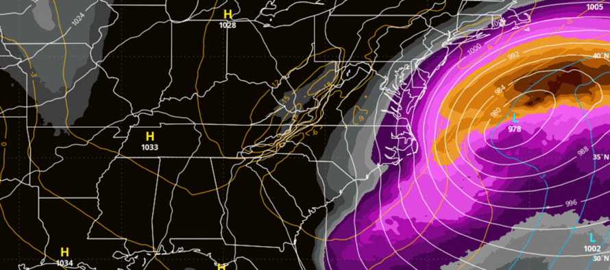
I am very glad we have one more day to formulate our general idea map for tomorrow (Thursday). It will not contain amounts but will outline how far into SENJ, possibly a little beyond, we expect snow to make it and how intense it might be. Data tonight through tomorrow 12z will be critical for our thoughts on tomorrow’s general idea map. I wish I had more confidence for you at this point but I do not. As I said before, we are dealing with a complex system of moving parts (atmospheric fluids) in a thread-the-needle timing situation. It involves a trough tilt, upper low cut-off, phase, and low capture. All nightmares for forecasters. This storm is going to have higher uncertainty right up through the 11th hour but we’ll do the best we can to provide you general expectations starting tomorrow. Snow maps would then occur Friday and Saturday before live observations begin late Saturday night. The image shown above is the European ensemble mean which is an average of many model runs of which many are still showing a decent NJ hit this Saturday night through most of Sunday.
In English: It’s starting to look like a no go for at least NWNJ (N of I-78 and NW of I-287 for reference). Areas between I-78/I-287 and I-95/NJTP cannot be taken off the table just yet but are heading in that direction. Areas SE of I-95/NJTP are becoming the most likely location to see snow from this storm, especially the SENJ coast from Monmouth down to Cape May. And it will be a very strong powerful storm offshore, likely meeting nor’easter criteria with at least a coastal flooding element involved. Timing is still Saturday night through Sunday if it hits. This storm has higher uncertainty than other storms due to how many moving parts and the thread-the-needle timing of a phase involved. We don’t have a good idea of how far snow will form on the NW side of the storm, regardless of low track and that would have big implications for NJ. We’ll review another 24 hours of data (big model runs tonight and tomorrow morning) and then issue a general idea map tomorrow. As of right now I am still at 60% on this happening SE of I-95/NJTP and 20-30% NW of I-95. Have a great rest of Wednesday and please be safe! JC
Premium Services
KABOOM Club offers an ad-free environment, inside info (Above and Beyond) forecast discussion, your questions prioritized, and early storm impact maps and video releases (ahead of the public). At $1.99 per month, it’s an extremely feasible way to show additional support for Weather NJ and you can turn it on and off for however many months you wish. Think of it as a tip jar with perks. Available onFacebook or Patreon.
My Pocket Meteorologist (MPM), in partnership with EPAWA Weather Consulting, offers professional/commercial interests, whose businesses depend on outdoor weather conditions (snow plowing, landscaping, construction, etc.), with hyper-local text message alerts/forecasts from real meteorologists and access to the MPM premium forum—the most comprehensive and technical forecast discussion available for PA and NJ commercial interests.
KABOOM Shop is live if you want some KABOOM or Weather NJ Merch!
Sign up for ZoneWatch Radar and get 10% off
Jonathan Carr (JC) is the founder and sole operator of Weather NJ, New Jersey’s largest independent weather reporting agency. Since 2010, Jonathan has provided weather safety discussion and forecasting services for New Jersey and surrounding areas through the web and social media. Originally branded as Severe NJ Weather (before 2014), Weather NJ is proud to bring you accurate and responsible forecast discussion ahead of high-stakes weather scenarios that impact this great garden state of ours. All Weather. All New Jersey.™ Be safe! JC


LOCAL FORECAST | INTERACTIVE RADAR | LATEST NJ WEATHER ALERTS | WEDDING FORECAST| PRIVACY POLICY
© Copyright 2026 Weather NJ LLC. All Rights Reserved.
Some information that can be found on our website is provided by a private weather station and is not an officially recognized station for weather reporting. Though we always strive to achieve accurate reporting for our own use, it is important that you do NOT depend on the data provided here for any purpose.
