

New Jersey Tries to Thaw Out
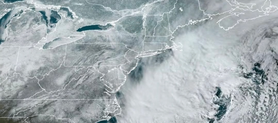
Discussion: The cover shot above is from NOAA GOES satellite imagery showing snow cover across the Mid-Atlantic, Northeast and plains regions of the US. Between the snowstorm last weekend not melting yet, due to Arctic air, and what just hit the Southern Mid-Atlantic US this past weekend, it almost looks like a mini-ice age or something. A reminder of the kind of classic winter NJ is still capable of seeing. And with that said, this winter continues to produce below-average temperatures with above-average snowfall. NNJ is the furthest above average in snowfall with some areas over 10 inches above. CNJ is generally about 5 inches above average and SNJ is anywhere from 1-3 inches above average for snowfall. This came from the following recap of events:
Dec 13-14 brought a significant snowstorm to the region where a general 4-8 inches accumulated across NJ. Dec 27 was the Warm Air Advection (WAA) event where 3-6 inches of accumulation fell across NNJ. Jan 16-18 (three weekends ago) was a double event weekend with NNJ squeezing out 3-6 on Friday (shortwave rode an Arctic front) and CNJ/SNJ 2-5 on Sunday (weak coastal low). Jan 25 (last weekend) was the snow to ice KABOOM with 12-16 across NNJ, 8-12 across CNJ and 4-8 across SNJ. This most recent weekend, we just missed a few snow bands that could have easily dropped another 1-3/2-4 on SENJ but all we saw was flurries/snow showers with little to no accumulation. In addition to the above listed events, we’ve seen a few nickel and dime events that have mostly produced coatings (lake effect/clipper).
We’re now going to take a break this week which, after three weeks in a row of intense tracking, I could sure use. The Arctic air will relax this week. Today actually feels warm at 31F after the past 10 days of below 19F. Tomorrow through Thursday we should actually rise above freezing during peak afternoon temperatures. A good chance to try and tackle the icy situations leftover from last weekend.
We do have two very minor looking snow producers this week. First is late Tuesday night into early Wednesday morning. This looks incredibly weak and is targeting SNJ. A coating to an inch might be too much of an expectation but given the colder temps during nighttime, we WILL have higher ratio snowfall to help stack anything up. 2 inches would likely be the max upside potential and only on an isolated basis. The second chance for some light snow is Friday in the form of a clipper. Need a few more days to better assess but would likely be similar to Tuesday night into Wednesday for max amounts. Both events are very weak sauce snow-wise. However. Please use caution as they could cause a few slick spots.
The Groundhog saw his shadow so six weeks of winter to go. I said my peace about that last night and still seek forgiveness from the Punxsutawney Phil commissions of NJ and PA. Perhaps Phil took a look at the 10-50mb stratospheric guidance suggesting a split of the Polar Vortex (PV) after a Sudden Stratospheric Warming Event (SSWE) last week. These instances typically take 2 weeks to propagate down to the troposphere. Which is likely why this Friday’s clipper will usher in the return of Arctic air for the rest of this weekend into next week. The pattern then looks active heading into the general Valentines Day window with a few signals to monitor that week.
In English: Temperatures moderate this week back into the low-to-mid 30s for afternoon high temperatures but still below freezing overnight. The week looks mostly dry aside from two chances for very light snow (late Tuesday night into Wednesday morning (favoring SNJ) and then on Friday (statewide)). At this point neither event looks disruptive to the point of closings and cancellations, possibly not even delayed openings. But they could produce enough light snow to slick up some surfaces with a coating to an inch or so. Key times to look out for this would be Wednesday morning and then during the day Friday. The Friday system will lead the charge of Arctic air rushing back over NJ to set up at least a cold weekend into next week. I’ll live cast anything that happens across SNJ tomorrow night. Otherwise have a great week and please be safe! JC
Premium Services
KABOOM Club offers an ad-free environment, inside info (Above and Beyond) forecast discussion, your questions prioritized, and early storm impact maps and video releases (ahead of the public). At $1.99 per month, it’s an extremely feasible way to show additional support for Weather NJ and you can turn it on and off for however many months you wish. Think of it as a tip jar with perks. Available onFacebook or Patreon.
My Pocket Meteorologist (MPM), in partnership with EPAWA Weather Consulting, offers professional/commercial interests, whose businesses depend on outdoor weather conditions (snow plowing, landscaping, construction, etc.), with hyper-local text message alerts/forecasts from real meteorologists and access to the MPM premium forum—the most comprehensive and technical forecast discussion available for PA and NJ commercial interests.
KABOOM Shop is live if you want some KABOOM or Weather NJ Merch!
Sign up for ZoneWatch Radar and get 10% off
Jonathan Carr (JC) is the founder and sole operator of Weather NJ, New Jersey’s largest independent weather reporting agency. Since 2010, Jonathan has provided weather safety discussion and forecasting services for New Jersey and surrounding areas through the web and social media. Originally branded as Severe NJ Weather (before 2014), Weather NJ is proud to bring you accurate and responsible forecast discussion ahead of high-stakes weather scenarios that impact this great garden state of ours. All Weather. All New Jersey.™ Be safe! JC


LOCAL FORECAST | INTERACTIVE RADAR | LATEST NJ WEATHER ALERTS | WEDDING FORECAST| PRIVACY POLICY
© Copyright 2026 Weather NJ LLC. All Rights Reserved.
Some information that can be found on our website is provided by a private weather station and is not an officially recognized station for weather reporting. Though we always strive to achieve accurate reporting for our own use, it is important that you do NOT depend on the data provided here for any purpose.
