

Historical Snowstorm Underway
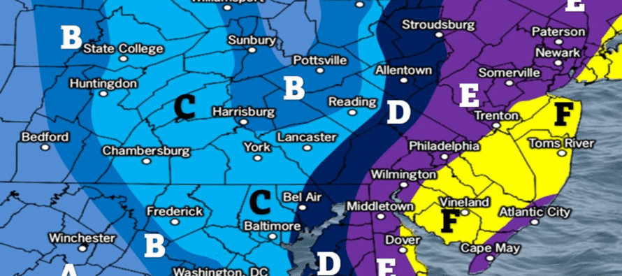
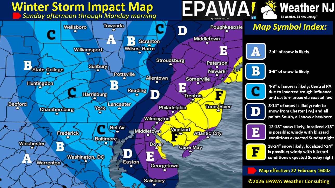
Discussion: This will be our final call snow map and forecast for this system. We’ve upgraded NNJ to now be all in the 12+ zone. That puts all of NJ in a KABOOM and still leaves Dude Where’s my Carr? on the table for somewhere in CNJ/SNJ at a localized/isolated basis. I will call it out in the middle of the storm if it seems warranted and imminent. Otherwise, it’s 12-18 for most of NNJ and 18-24 for most of SNJ with CNJ sitting around the middle mark of ~18. We lowered some amounts for Eastern PA to account for latest data trends on precipitation shield NW and W extent.
Winds will reach peak intensity around midnight tonight but it’s going to crank from 6pm to 6am tonight (Sunday) into tomorrow (Monday). 50-70mph gusts along the immediate ECNJ/SENJ coasts are possible. 40-55mph gusts are possible away from the ocean in the rest of NJ.
Coastal flooding is likely around the same time as the peak winds tonight. Moderate coastal flooding seems like the most realistic and reasonable expectation however low-end of major cannot be taken off the table. Again, no full or new moon, not much rain draining into everything, but a strong wind-driven storm surge.
All of NJ should be over to snow by 2pm. The current snow/rain line is just starting to crash southward and last I checked was just S of I-78. Already starting to see pockets change to snow over Delaware so it’s coming soon. The coastal low (will become the nor’easter) is popped at 1006mb off OBX and the upper low has closed off over Ohio. The upper low will now throw it’s lasso over the surface low and yank it towards the Jersey coast before releasing it Monday morning. During this period, we will KABOOM and possibly Dude Where’s my Carr? locally. Here is our final call snow map and forecast.
In English: Snow and rain have broken out in NJ and rain is changing to snow from N to S. All of NJ should be all snow by 2pm. It will then take a little to chill the ground to the point of stickage. Conditions go downhill starting around 2pm but really go downhill from 5pm-forward. We reach peak snowstorm intensity (snow, wind and coastal flooding) overnight and then we taper off tomorrow (Monday) from noon to 5pm from W to E. I will post a live observation reel once all of NJ is over to snow. Good luck to everyone and please be safe! JC
Premium Services
KABOOM Club offers an ad-free environment, inside info (Above and Beyond) forecast discussion, your questions prioritized, and early storm impact maps and video releases (ahead of the public). At $1.99 per month, it’s an extremely feasible way to show additional support for Weather NJ and you can turn it on and off for however many months you wish. Think of it as a tip jar with perks. Available onFacebook or Patreon.
My Pocket Meteorologist (MPM), in partnership with EPAWA Weather Consulting, offers professional/commercial interests, whose businesses depend on outdoor weather conditions (snow plowing, landscaping, construction, etc.), with hyper-local text message alerts/forecasts from real meteorologists and access to the MPM premium forum—the most comprehensive and technical forecast discussion available for PA and NJ commercial interests.
KABOOM Shop is live if you want some KABOOM or Weather NJ Merch!
Sign up for ZoneWatch Radar and get 10% off
Jonathan Carr (JC) is the founder and sole operator of Weather NJ, New Jersey’s largest independent weather reporting agency. Since 2010, Jonathan has provided weather safety discussion and forecasting services for New Jersey and surrounding areas through the web and social media. Originally branded as Severe NJ Weather (before 2014), Weather NJ is proud to bring you accurate and responsible forecast discussion ahead of high-stakes weather scenarios that impact this great garden state of ours. All Weather. All New Jersey.™ Be safe! JC


LOCAL FORECAST | INTERACTIVE RADAR | LATEST NJ WEATHER ALERTS | WEDDING FORECAST| PRIVACY POLICY
© Copyright 2026 Weather NJ LLC. All Rights Reserved.
Some information that can be found on our website is provided by a private weather station and is not an officially recognized station for weather reporting. Though we always strive to achieve accurate reporting for our own use, it is important that you do NOT depend on the data provided here for any purpose.
