

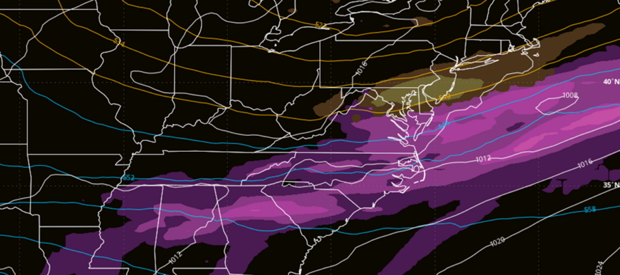
Tracking Some Weak Sauce
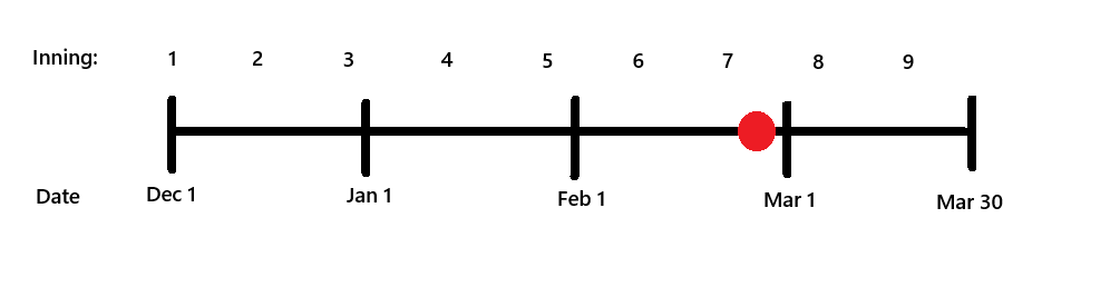
Discussion: You can really feel the late-February higher sun angle and climatology now in play. I first felt it last Sunday (Feb 15) when only 1-3 inches of snowfall stuck (mostly on grass only) from 3-6 inches falling out of the sky. Then again with this past storm. It got rather mild Saturday and especially Sunday morning…temps took a while to get down to freezing, even under heavy initial snow post-changeover. Then when it was ripping snow overnight under the massive snowstorm, temps struggled to fall more than a few degrees below freezing. If it was late-December or January, this storm would have pushed temps at least down to lower-20s. Then yesterday, I felt it most when it was still ripping snow but mid-day temps were 33-34 inhibiting further stickage. My snowpack has already compacted a lot and continues today even with below-freezing temps. Notice it feels rather mild for being below freezing? We still have some time to go but winter is certainly approaching its sunset. After the cold and snow we’ve endured this season, I’m finding that many, even snow enthusiasts, are ready for spring. Here’s where we are in the baseball game.
So going forward, for lighter snow events to accumulate they need cold air out ahead of it (NJ inside of a trough/behind recent cold front) and/or need to fall overnight to escape the higher sun angle. A more major event would still override this but even this past storm struggled to accumulate during both daytime periods of Sunday and Monday. Just want to set the tone for any additional snowfalls we see between now and the end of this snow season.
The next snowfall potential is tomorrow morning (2am to 9am) in the form of a clipper which is a colder N stream system. The departing major storm ripped some colder air down behind it. NJ should range from 29-33 NNJ-SNJ for highs today and fall to the 24-28 range overnight tonight. The combination of existing snowpack and clear skies should assist with some radiational cooling and possibly get us a few degrees colder than that. The low is well to our N in Canada so we’re dealing with mostly a cold front attached to its S side. It seems to be targeting NNJ/CNJ more so than SNJ. Clippers are moisture-starved systems that rarely drop more than a coating to a few inches of snow. I’ve seen 3-6 out of them before but they were much more potent than what’s coming tomorrow morning. The biggest safety hazard from a clipper is a temporary reduction of visibility because it can dump rather hard at times. In any case, tomorrow morning’s clipper should be another routine coating to an inch style clipper with maybe NNJ/NWNJ seeing a little more, but likely no more than 2 with 3 a maximum upside potential. There should be a quick melt after sunrise, especially on paved surfaces, as afternoon high temps on Wednesday will be heading back up into the 40s, possibly mid-to-upper 40s. Bottom line on the clipper is: Not a big deal but visibility reduction and some slick surfaces are possible tomorrow morning, especially in NNJ, until temps rise above freezing (by 10am at the latest).
Then we have another snow opportunity Thursday afternoon into Thursday evening (Feb 26). This one is a quick mover that will track along the frontal boundary pulled down by the clipper. So how far that boundary gets yanked southward behind the Wednesday morning clipper will determine the latitude of a snow swath running W to E Thursday PM. The GFS is the furthest N with it passing over SNJ, dropping a 1-3/2-4 situation at most. Again, daytime into early evening snowfall caveat with surfaces their warmest and only just cooling down for snowfall. More of a “snow on the grass only” type thing. The Euro and Canadian are not excited about it with little to no precipitation just grazing extreme SNJ. We will have to see how the clipper comes through tomorrow morning before deciding if a snow map is even needed for Thursday evening.
Overall, the Wed morning clipper and Thursday evening wave look like weak sauce and could produce conversational snowfall at most. The next signal of greater interest to me is the March 2-4 period (next Monday-Wednesday). Models are indicating a more potent wave for that period but still highly uncertain with a marginal temperature profile. That might be the last shot at snow for a while. Another synoptic system is showing up for the March 5-7 period that looks more like a rainmaker to take us into at least a week of milder temperatures. Assuming that takes us through mid-March, sun angle and climatology will make it even harder to see accumulating snowfall. It’s possible (still in the baseball game – see above) as we have been painfully reminded by the March 1993, 2014 and 2017 (and a few others) ends of winters past. But it takes a strong cold setup and/or system. So that’s where we’re at. Let’s take each wave one system at a time. Here is a snow map for tomorrow morning’s clipper:
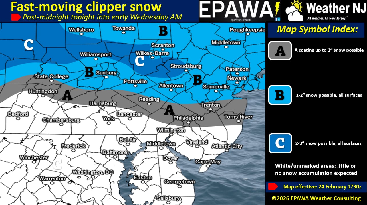
In English: A clipper could bring a coating to an inch of snow through NNJ/CNJ (less so for SNJ), maybe a 1-3 situation for NNJ/NWNJ tomorrow (Wednesday) morning. Not a big deal but could reduce visibility during times of snowfall and slightly slicken up untreated surfaces. We then warm for a quick melt Wednesday afternoon but fall again Wednesday night into Thursday. Thursday still gets above freezing for many but then as the sun sets and temps feather down, more snow is possible Thursday night mainly for SNJ (either a light hit or barely a graze). Another quick mover so maximum upside potential is a 2-4 event but likely less will actually fall and stick. Watching March 2-4 for another snow system then March 5-7 for a warmer system to take us into a period of prolonged mild temperatures. Winter is cracking at the seems but we do have to give it through the end of March for the baseball game to end (see above baseball timeline image). Be safe! JC
Premium Services
KABOOM Club offers an ad-free environment, inside info (Above and Beyond) forecast discussion, your questions prioritized, and early storm impact maps and video releases (ahead of the public). At $1.99 per month, it’s an extremely feasible way to show additional support for Weather NJ and you can turn it on and off for however many months you wish. Think of it as a tip jar with perks. Available onFacebook or Patreon.
My Pocket Meteorologist (MPM), in partnership with EPAWA Weather Consulting, offers professional/commercial interests, whose businesses depend on outdoor weather conditions (snow plowing, landscaping, construction, etc.), with hyper-local text message alerts/forecasts from real meteorologists and access to the MPM premium forum—the most comprehensive and technical forecast discussion available for PA and NJ commercial interests.
KABOOM Shop is live if you want some KABOOM or Weather NJ Merch!
Sign up for ZoneWatch Radar and get 10% off
Jonathan Carr (JC) is the founder and sole operator of Weather NJ, New Jersey’s largest independent weather reporting agency. Since 2010, Jonathan has provided weather safety discussion and forecasting services for New Jersey and surrounding areas through the web and social media. Originally branded as Severe NJ Weather (before 2014), Weather NJ is proud to bring you accurate and responsible forecast discussion ahead of high-stakes weather scenarios that impact this great garden state of ours. All Weather. All New Jersey.™ Be safe! JC


LOCAL FORECAST | INTERACTIVE RADAR | LATEST NJ WEATHER ALERTS | WEDDING FORECAST| PRIVACY POLICY
© Copyright 2026 Weather NJ LLC. All Rights Reserved.
Some information that can be found on our website is provided by a private weather station and is not an officially recognized station for weather reporting. Though we always strive to achieve accurate reporting for our own use, it is important that you do NOT depend on the data provided here for any purpose.
