


Mon-Fri Storms to Break Humidity for Weekend

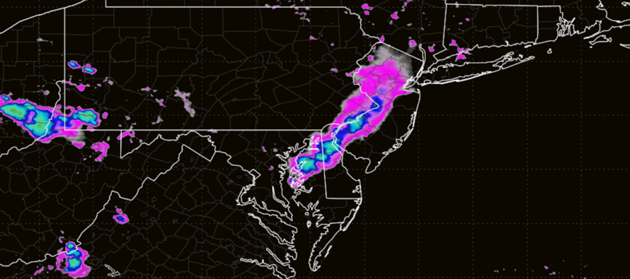
Discussion: The general upper level flow pattern should remain in place this week. A ridge currently over the SW US will slowly advance E towards the SE US by this weekend. At the same time, a trough in SE Canada will squeeze the upper-jet flow from a zonal flow this week toward more of a meridional flow by this weekend as the ridge bumps the C US jet northward. So upper flow will transition from W/NW to N/NW between now and Friday night. This will keep thunderstorm chances alive today (Monday) through Thursday/Friday with today likely the stormiest (via stormfront). Tues-Friday more of an isolated to scattered storm chance. Regardless, storms could produce more episodes of flash flooding and wind damage at an isolated/localized basis with the general widespread expectation of more routine storms popping up in the afternoon/evening hours. This evening, however, is a more potent stormfront expected to push through NJ from W/NW to E/SE between about 4-8pm. Humidity should remain elevated (dews > 70) straight through at least Friday morning. By Friday night/early Saturday morning, a cold front should push through NJ from N to S that should drop dews less than 60 and prevent Saturday high temperatures from exceeding the lower-80s. With that said, Friday night through all of Saturday into Sunday morning looks immaculate for mid-to-late summer and should feature the relief we’re all looking for. On Sunday, humidity returns as well as rain/storm chances for PM hours.
I see the uptick in tropical cyclone development potential, especially off the W Coast of Africa/Cape Verde region. Such systems will only be casually tracked until it becomes possible for NJ impacts. Then such systems will be seriously tracked until they either hit or just miss NJ. There’s a lot of desert dust coming off the Sahara and there’s a lot of shear near/N of the Caribbean Sea. This is common during an El Nino cycle and it typically produces a less active tropics season for NJ/NE US while enhancing the season potential for the actual tropical latitudes (includes Caribbean Islands, Gulf, Bahamas and SE US). That’s not to say it can’t happen for NJ/NE US…just that there is some global pattern stuff working against it. As you all know by now, I will do my best to report accordingly. As of now, there are three areas being watched closely in the Atlantic Ocean. One is actually E of OBX/N of Bermuda but should continue tracking E and away from the US as a weak wave. Another wave is currently in the trade winds, aimed at the S Lesser Antilles and should have no potential impact on NJ in the future. The most prominent activity is a few hundred miles SW of the Cape Verde islands and currently is aimed at the N Lesser Antilles. I will be watching how this low-pressure wave evolves and how it could possibly be steered by downstream forces (troughs, ridges, etc.) and/or intensified/weakened by other forces (dust, shear, water temps, etc.). The next tropical name is Cristobal for whatever does form/intensify into at least a Tropical Storm. For now, there’s nothing to panic about…just the observation that the tropics are coming alive right at the start of peak hurricane season. More of just an unremarkable observation.
Forecast
Monday (Aug 10) high temperatures should reach the mid-to-upper 80s for most NJ locations with the typical hotter spots near I-95 likely breaking into the lower-90s. Humidity will remain elevated. A main stormfront of showers and thunderstorms are possible between 4-8pm but should only last about 1-2 hours within that window…will be moving W/NW to E/SE. Thunderstorms could produce frequent lightning, flash flooding and damaging wind gusts locally/isolated while most areas see just downpours, lesser wind gusts and rumbles. Winds should be generally light out of the SW. Overnight lows should fall to the 68-75 range NNJ to SNJ with isolated showers and thunderstorms still around.
Tuesday (Aug 11) high temperatures should reach the mid-to-upper 80s for most NJ locations with a few spots just reaching 90. Humidity should remain elevated with shower and thunderstorms possible, especially during afternoon-evening hours. Not a stormfront like Monday…more of just an isolated-to-scattered threat. Winds should be light out of the W/NW. Overnight lows should fall to the 60-75 range NNJ to SNJ with a calmer overnight into Wednesday morning than Monday night into Tuesday morning.
Wednesday (Aug 12) high temperatures should reach the low-to-mid 80s for most NJ locations. While not as hot, humidity will still remain elevated for a hotter feel. Skies should be mixed with sun and clouds. Isolated showers and thunderstorms are possible during afternoon-evening hours but favoring SNJ over NNJ/CNJ. Winds should be light out of the W/SW for SNJ and a little more out of the W/NW for NNJ/CNJ. Overnight lows should fall to the 60-70 range NNJ to SNJ with a humid feel.
Thursday (Aug 13) high temperatures should reach the 85-90 range for most NJ locations. Skies should be mixed with sun and clouds with elevated humidity persisting. Isolated showers and thunderstorms are possible for afternoon/evening hours. Winds should be light out of the SW for SNJ and more W/NW for NNJ/CNJ. Overnight lows should fall back to the 65-75 range NNJ to SNJ with a humid feel and a few more isolated showers/rumbles around.
Friday (Aug 14) high temperatures should reach the mid-to-upper 80s for most NJ locations. A transitional day/night as a cold front will be sinking southward out of the north. So the day could start sticky in the morning but feature a much better feel around/after sunset. Skies should be mixed with sun and clouds with a humid feel during the day. Have to assume at least some isolated activity is possible along the cold front that will move N to S. But the frontal passage appears mostly dry as of now. Regardless, on the other side of the front exists a beautiful weekend starting with Friday night. Winds should be light out of the NW (after the front). Overnight lows should fall to the 55-65 range NNJ to SNJ with dropping dew points (lower humidity – RELIEF!)
An early look at the weekend (Aug 15-16) indicates an incredible and dry looking Saturday. I’m seeing highs around 80-83 with dews in the 50s. That should feel amazing after the hot and humid conditions endured lately and through this Friday. Unfortunately, it won’t last long with humidity building back in for Sunday along with rain and storm possibilities later in the day. But from Friday night through about Sunday morning (includes all of Saturday hours), expect some amazing-feeling relief. Have a great week and please be safe! JC
Premium Services
KABOOM Club offers an ad-free environment, inside info (Above and Beyond) forecast discussion, your questions prioritized, and early storm impact maps and video releases (ahead of the public). At $1.99 per month, it’s an extremely feasible way to show additional support for Weather NJ and you can turn it on and off for however many months you wish. Think of it as a tip jar with perks. Available onFacebook or Patreon.
My Pocket Meteorologist (MPM), in partnership with EPAWA Weather Consulting, offers professional/commercial interests, whose businesses depend on outdoor weather conditions (snow plowing, landscaping, construction, etc.), with hyper-local text message alerts/forecasts from real meteorologists and access to the MPM premium forum—the most comprehensive and technical forecast discussion available for PA and NJ commercial interests.
KABOOM Shop is live if you want some KABOOM or Weather NJ Merch!

Jonathan Carr (JC) is the founder and sole operator of Weather NJ, New Jersey’s largest independent weather reporting agency. Since 2010, Jonathan has provided weather safety discussion and forecasting services for New Jersey and surrounding areas through the web and social media. Originally branded as Severe NJ Weather (before 2014), Weather NJ is proud to bring you accurate and responsible forecast discussion ahead of high-stakes weather scenarios that impact this great garden state of ours. All Weather. All New Jersey.™ Be safe! JC



LOCAL FORECAST | INTERACTIVE RADAR | LATEST NJ WEATHER ALERTS | WEDDING FORECAST| PRIVACY POLICY
© Copyright 2026 Weather NJ LLC. All Rights Reserved.
Some information that can be found on our website is provided by a private weather station and is not an officially recognized station for weather reporting. Though we always strive to achieve accurate reporting for our own use, it is important that you do NOT depend on the data provided here for any purpose.

