A Look through March of 2017

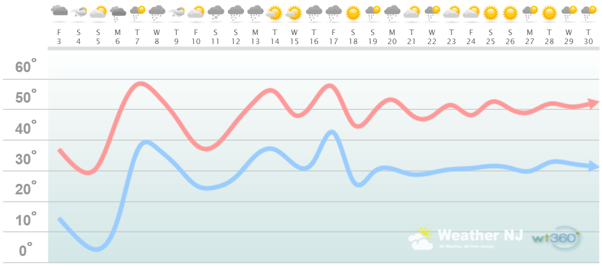
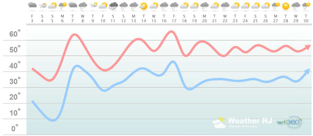
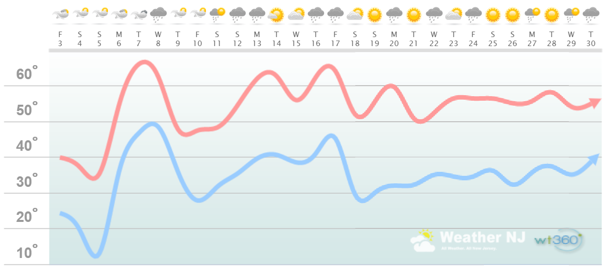
It’s time to harness the WeatherTrends360 proprietary weather algorithms to see how the rest of March 2017 should play out. But first lets break New Jersey into proper climatological regions. We have the higher elevations of NNJ/NWNJ, the interior coastal plain (SWNJ through CNJ and into NENJ), and the coastal regions (most of SENJ). I’ll be representing each climatological region with a 28-day graph from weathertrends360 data followed by a brief discussion.
Please keep in mind that these algorithms are documented with an 84% verification rate and are based on oceanic water cycles, time table series and very complex mathematics. The best takeaway from this data are general trends (cool vs warm, rainy vs dry, etc). I’m always hesitant to forecast specific surface conditions (rainfall amounts, snowfall amounts, winds, etc) beyond the 4-7 day forecasting period. But temperature and precipitation trends is what WeatherTrends360 does best with their proprietary mathematical analysis derived from over 150 years of reactive pattern data. For this reason, let’s call this a long-range discussion of expectations rather than a locked-in forecast.
Higher Elevations of NNJ/NWNJ
(Sussex, Warren, Hunterdon, Morris, N. Somerset, and N. Passaic) – Known for little to no Atlantic Ocean influence, colder-snowier winters, and drier conditions in general when compared to the coast. This region is known to get hot when high pressure sits overhead during the summer and bitterly cold during Arctic outbreaks in the winter. Elevation is a major influence that separates this micro-climate from the rest of New Jersey. This region extends into NE PA (Poconos) and parts of NY State (Catskills).
Higher Elevation Discussion: This region has 3 main features showing up in the next few weeks worth mentioning. First are the immediate colder temperature anomalies that should dominate this weekend. Second are the warmer temperatures that should snap back for early next week. We’ll likely see frontal rain and possibly thunderstorms with that unsettled March 6-8 period. We should then dip colder later next week to set up another unsettled weekend for March 11-13. It appears that’s the most prominent precipitation chance of long-range period. If temperatures support it, there might be some snow with that. I wouldn’t hold your breath the way this winter has gone. Rain would be the most likely outcome. Beyond that, temperatures and precipitation appear to level out to normal levels through the rest of March.
Interior Coastal Plain from SWNJ-CNJ-NENJ
(Salem, Gloucester, Camden, W. Burlington, Mercer, W. Monmouth, Middlesex, S. Somerset, Union, Essex, Hudson, Bergen, and S. Passaic) – Known for naturally higher temperatures due to lower elevations away from the oceanic influence. This region is also known as “heat island” due to transportation (I-95 corridor), smog, abundant asphalt, concrete, and other man-made substances that naturally absorb and retain heat moreso than natural protected land. This is why excessive heat warnings and air quality alerts are more common in this region. SWNJ always tends to run a few degrees warmer than NENJ but this region is very similar otherwise in micro-climate due to the parallel nature of the Appalachian Mountain elevations to the NW. The same micro-climate can be extended into SE PA and NE MD which tends to run just a little stormier than NJ. This however is what makes up the interior coastal plain.
Interior Coastal Plain Discussion: This region has 3 main features showing up in the next few weeks worth mentioning. First are the immediate colder temperature anomalies that should dominate this weekend. Second are the warmer temperatures that should snap back for early next week. This specific region has the best chance of flirting with 70+ again but 60s are pretty much locked-in. We’ll likely see frontal rain and possibly thunderstorms with that unsettled March 6-8 period. We should then dip colder later next week to set up another unsettled weekend for March 11-13. It appears that’s the most prominent precipitation chance of long-range period. If temperatures support it, there might be some snow with that. I wouldn’t hold your breath the way this winter has gone. Rain would be the most likely outcome. Beyond that, temperatures and precipitation appear to level out to normal levels through the rest of March.
Coastal Regions of SENJ
(Cumberland, Cape May, Atlantic, E. Burlington, Ocean, and E. Monmouth) – Known for tremendous influence from the Atlantic Ocean. Oceanic influence keeps this zone cooler in the summer and warmer in the winter than the interior coastal plain and especially the higher elevations of NWNJ. In the summer, sea breeze fronts back into the coast and can ignite thunderstorms if enough instability is present. The cooler marine air slides under the hot air to the W and provides additional atmospheric lifting. This is both why it’s 5-15 degrees cooler at the shore than the Philly-Trenton area and why near-stationary thunderstorms can form along the coast capable of producing localized flash flooding. In the winter, the ocean is warmer than interior regions which plays a huge role in rain vs. snow—highly dependent on wind direction. When the winds chance from NE to N/NE, that’s usually when temps crash and change rain over to snow. Regardless, this micro-climate is well known, well documented and well expressed. This region extends into most of Delaware as well.
Coastal Region Discussion: This region has 3 main features showing up in the next few weeks worth mentioning. First are the immediate colder temperature anomalies that should dominate this weekend. Second are the warmer temperatures that should snap back for early next week. Keep in mind that this specific region is more buffered/moderated by the colder ocean temps (around 40-41F). We’ll likely see frontal rain and possibly thunderstorms with that unsettled March 6-8 period. We should then dip colder later next week to set up another unsettled weekend for March 11-13. It appears that’s the most prominent precipitation chance of long-range period. If temperatures support it, there might be some snow with that. I wouldn’t hold your breath the way this winter has gone. Rain would be the most likely outcome. Beyond that, temperatures and precipitation appear to level out to normal levels through the rest of March.
Weathertrends360 is a complete, global, web solution to help retailers and suppliers capitalize on the weather and its influence on sales and marketing plans up to a year ahead. Learn how to become PROACTIVE vs REACTIVE with the weather in every phase of your business – how much inventory to buy/produce, where to allocate more/less, when to run weather-optimized advertising/marketing campaigns – weathertrends360 can help you determine all of this in minutes! 84% independently audited accuracy for both short-term and year-ahead forecasts for temperature and precipitation.
In English: Overall, we’re looking cold this weekend, warmer early next week and then near-average for the rest of the month. For March that means snow is not likely however temperatures should fall short of outside comfort. As far as precipitation goes, we should see some early next week and then next weekend. The rest of the month appears to feature average precipitation. Many areas are still in a drought as fire season peaks so please exercise fire safety out there, especially on breezy days. Everyone have a great month of March and please be safe! JC
Jonathan Carr (JC) is the founder and sole operator of Weather NJ, New Jersey’s largest independent weather reporting agency. Since 2010, Jonathan has provided weather safety discussion and forecasting services for New Jersey and surrounding areas through the web and social media. Originally branded as Severe NJ Weather (before 2014), Weather NJ is proud to bring you accurate and responsible forecast discussion ahead of high-stakes weather scenarios that impact this great garden state of ours. All Weather. All New Jersey.™ Be safe! JC


