

A Stormy Night for Some
Discussion: Most model guidance has the surface low tracking from Ohio/W PA now through North-Central PA overnight/by morning, and into NY State/SE Canada by tomorrow afternoon. Given the proximity of the low’s track and track speed, NJ will spend a short time in the corner of the warm sector.
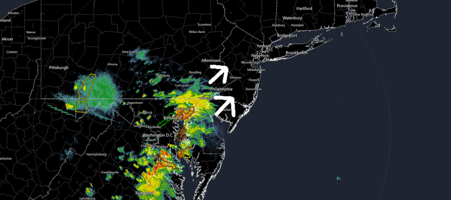
The warm front is what’s approaching SWNJ now (see radar image above). I expect this to continue moving to the N/NE with likely more impact to WNJ than ENJ overnight. The energy should then consolidate and pull into the NY State-located surface low later tomorrow (Thursday) morning. But for tonight/early tomorrow morning, the warm sector looks rainy and stormy with maybe some isolated severe criteria met here and there. The more probable scenario are non-severe downpours/storms.
At some point tomorrow morning, your location will spend that quick time in the warm sector. During such it will be muggy (high humidity) with isolated showers possible. More rain, possibly storms, should then push through from W to E ahead of the cold front. Should be from about 7-9am from W to E. The precip should shut off by 10am and the cold front should push completely through by early afternoon, if not sooner. Conditions should then significantly improve with clear conditions likely the rest of Thursday/Thursday night and all of Friday.
In English: Rain and storms are approaching SWNJ right now and should push up WNJ overnight with maybe some expansion into ENJ. Looks mostly non-severe but can’t rule out isolated severe. A small humid break tomorrow morning before more rain and storms push through from W to E between about 7am and 9am. Could make for a slow AM commute. Much improvement tomorrow (Thursday) afternoon through all of Friday. The weekend still looks a bit unsettled but less washout and more nuisance. I’ll have the detailed weekend outlook posted tomorrow evening. Have a great night and please be safe! JC
Premium Services
KABOOM Club offers inside info forecast discussion, your questions answered, and early storm impact maps (ahead of the public). At a buck per month, it’s an extremely feasible way to show support for JC.
My Pocket Meteorologist (MPM), in partnership with EPAWA Weather Consulting, offers professional/commercial interests, whose businesses depend on outdoor weather conditions (snow plowing, landscaping, construction, etc.), with hyper-local text message alerts/forecasts and access to the MPM premium forum—the most comprehensive and technical forecast discussion available for PA and NJ.
Jonathan Carr (JC) is the founder and sole operator of Weather NJ, New Jersey’s largest independent weather reporting agency. Since 2010, Jonathan has provided weather safety discussion and forecasting services for New Jersey and surrounding areas through the web and social media. Originally branded as Severe NJ Weather (before 2014), Weather NJ is proud to bring you accurate and responsible forecast discussion ahead of high-stakes weather scenarios that impact this great garden state of ours. All Weather. All New Jersey.™ Be safe! JC


LOCAL FORECAST | INTERACTIVE RADAR | LATEST NJ WEATHER ALERTS | WEDDING FORECAST| PRIVACY POLICY
© Copyright 2026 Weather NJ LLC. All Rights Reserved.
Some information that can be found on our website is provided by a private weather station and is not an officially recognized station for weather reporting. Though we always strive to achieve accurate reporting for our own use, it is important that you do NOT depend on the data provided here for any purpose.
