

An Interesting Week Ahead
Discussion: We’ve got an interesting week ahead. A total lunar eclipse, two fronts, roller coaster temperatures, remnants of Nicole, etc. all leading to a much colder pattern with even some snow showing up on long-range model guidance. A bit longer of a discussion today but let’s get into it…
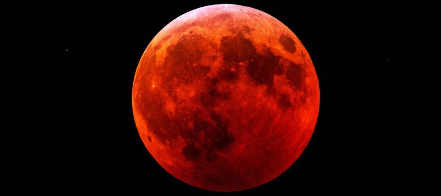
Today is the last day of the freakish warmth and humidity. Ridging over Maine is breaking down and transferring towards the Great Lakes. This will change our upper-level flow from SW to NW. High pressure, riding the front of the ridge transition, will now drive N flow into NJ at the lower levels and cool us off for a few days. This constitutes the first of two fronts which should push through NJ as a dry cold front this evening/tonight. Therefore, tonight (Monday night), expect a solid drop in both temperature and humidity especially after sundown. Some places could go from 75-80 down to 40 possibly less between now and sunrise tomorrow (Tuesday) morning. Tuesday and Wednesday then look cooler and dryer with high pressure approaching/overhead. With that said, conditions look ideal for viewing the lunar eclipse tomorrow morning (Tuesday) between 3am and 9am Eastern Time with maximum eclipse occurring around 6am. This will be just before the moon sinks below the horizon in the SW sky. After about 6:30am the eclipse will go on but below our (NJ) line of horizon sight. Also, the sun will be rising. Central and W US have a better shot at seeing the entire event. But NJ will see a low-horizon full red moon, while still dark.
Once the Tues-Weds high pressure gets E of NJ (over the Atlantic Ocean), it will begin pumping in warmer and more humid air mass again via return flow. This will warm Thursday and Friday back up as another warm sector moves in ahead of front #2. By Friday PM, remnants of Nicole are expected to slide up the coast just ahead of the second front. This brings us to the rainy, likely windy, possibly stormy conditions expected between Friday evening and at least Saturday afternoon, possibly Saturday evening. Let’s discuss Nicole real quick:
Nicole is currently approaching the N Bahamas from the W. It could reach category 1 hurricane strength before grazing/making landfall in the N Bahamas this Wednesday. Nicole is then expected to continue westward and make landfall somewhere in the ~W Palm Beach area either late Wednesday night or Thursday morning, possibly as a cat 1 hurricane. This could create a hazardous surge situation for ~W Palm Beach and immediate coastal points N of such, despite the lower category hurricane classification. Coastal FL areas S of the eye, during landfall, would make out much better regarding wind surge and tidal flooding concerns but would still get in on the higher winds near the eye. From there, Nicole should then weaken and turn to the N to ride the W coast of FL northward before recurving back towards the SE US coast by Saturday.
Right now, for NJ, it looks like a few inches of mild-feeling rain and maybe moderate winds between Friday night and at least Saturday afternoon. Bye-bye remaining tree leaves. Most of Nicole’s structure will be well-deteriorated by this time. The center of original circulation should actually miss NJ well to the S (off OBX). It’s more of a stormy/rainy slug of energy/moisture that’s expected to break off and slide northward up the EC to NJ. By Saturday night, the tropical remnant rain should clear out to sea and then the cold front should push through NJ by Sunday morning. Sunday then looks like a day of transition as the sun tries to do its thing, but with a noticeable downturn in temperature and humidity. Sunday evening (especially sunset and after) should then feel more like December than November and this feel should last through most of next week. We’re talking highs in the 40s and lows in the 20s for much of NJ.
The last part of this discussion involves possible first snowflakes of the colder season. I wouldn’t get too excited as we’re still a bit early climatologically and it would mostly be for NWNJ elevations. But the ~Nov 16-18 period interests me a bit when looking at the teleconnections. Long-range model guidance is suggesting a few short waves coming together with a trough. The trough axis is modeled positive so would also be a quick mover. Might just be a close coastal miss with almost some snow for NJ on the NW side. We obviously still have a bunch of time. But it looks like something wants to happen with a very cold air mass pushing in behind it. There is also the possibility for lake-effect flurries once the cold air mass moves in after the possible coastal. With that said, it looks cold in NJ from about this Sunday (Nov 13) heading into the Thanksgiving period. A complete reversal from the first 12 days of the month. Ok, here’s your weekly outlook in English:
Monday (Nov 7) high temperatures should easily reach the low-to-mid 70s, maybe higher for interior CNJ/SNJ. The final day of the very mild stretch. Skies should be mainly sunny. A few friendly clouds around, especially later with the dry front. Winds should be light and gradually shift from W/SW to W/NW throughout the day and ultimately NW overnight. This should lower humidity by late-afternoon. Overnight lows should fall to the 35-45 range from elevations to coasts. A sharp contrast between afternoon high temps and overnight lows with some areas falling over 30 degrees.
Tuesday (Nov 8) high temperatures should reach the upper-50s for most areas. Maybe some spots tap 60. Noticeably less humidity with mostly sunny skies. 3am-9am looks clear if you are braving it for the total lunar eclipse viewing. The full red moon (maximum eclipse) should be around 6am which will be low on the SW horizon just before sinking below the Earth’s horizon. Winds should be light out of the N/NW. Overnight lows should fall into the upper-20s/30s for most. ECNJ/SENJ coastal regions could hang just above 40.
Wednesday (Nov 9) high temperatures should reach the mid-to-upper 50s. Skies should be mixed with sun and clouds. Winds should be light out of the E/NE. Overnight lows should fall into the 30s for most with immediate coastal areas again likely hanging above 40.
Thursday (Nov 10) high temperatures should reach back up into the 60s again. Skies should be mostly sunny. Winds should be light out of the S/SW. Overnight lows should range from 45-55 from elevations to coasts.
Friday (Nov 11) high temperatures should reach the mid-to-upper 60s for most areas Skies should be mostly cloudy with rain eventually moving in and becoming steadier for overnight hours. Winds should be light out of the SE, breezy along the SENJ coast. Overnight lows should sit with ocean temps in the mid-to-upper 50s.
An early look at the weekend indicates at least a rainy Saturday from Nicole’s remnants (this is what moves in by Friday PM). Whether or not there will be flash flooding or higher wind concerns is yet TBD. I’ll be tracking and reporting this week as we further approach. Sunday looks transitional as a much colder air mass approaches. Sunday night through next week might feel December-ish after the recent May-ish conditions. Everyone have a great week and please be safe! JC
Premium Services
KABOOM Club offers inside info forecast discussion, your questions answered, and early storm impact maps (ahead of the public). At a buck per month, it’s an extremely feasible way to show support.
My Pocket Meteorologist (MPM), in partnership with EPAWA Weather Consulting, offers professional/commercial interests, whose businesses depend on outdoor weather conditions (snow plowing, landscaping, construction, etc.), with hyper-local text message alerts/forecasts and access to the MPM premium forum—the most comprehensive and technical forecast discussion available for PA and NJ.
Jonathan Carr (JC) is the founder and sole operator of Weather NJ, New Jersey’s largest independent weather reporting agency. Since 2010, Jonathan has provided weather safety discussion and forecasting services for New Jersey and surrounding areas through the web and social media. Originally branded as Severe NJ Weather (before 2014), Weather NJ is proud to bring you accurate and responsible forecast discussion ahead of high-stakes weather scenarios that impact this great garden state of ours. All Weather. All New Jersey.™ Be safe! JC


LOCAL FORECAST | INTERACTIVE RADAR | LATEST NJ WEATHER ALERTS | WEDDING FORECAST| PRIVACY POLICY
© Copyright 2026 Weather NJ LLC. All Rights Reserved.
Some information that can be found on our website is provided by a private weather station and is not an officially recognized station for weather reporting. Though we always strive to achieve accurate reporting for our own use, it is important that you do NOT depend on the data provided here for any purpose.
