

Another Late-Weekend Storm Detected
Discussion: A strong ridge, centered over the Great Lakes, will dominate our New Jersey weather pattern for the next few days (through Sunday) with dry and milder conditions. Here’s the latest GFS-modeled ridge for later tonight into tomorrow morning. Notice the NW upper flow that has brought colder flow for the past few days.
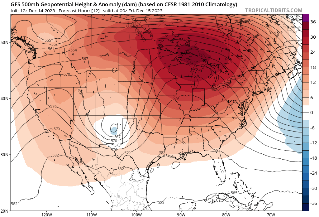
As that ridge slides eastward, the upper flow will become SW over New Jersey under the back of the ridge. Then a transient trough will pass through associated with the Sunday-Monday storm system. The trough will then lift out and allow another period of ridging next week into next weekend. It then gets interesting for the second storm signal on or around December 23-24. The ridge flexes hard in SE Canada while an upper low meanders off the Mid-Atlantic US. Here’s that output for Dec 23.
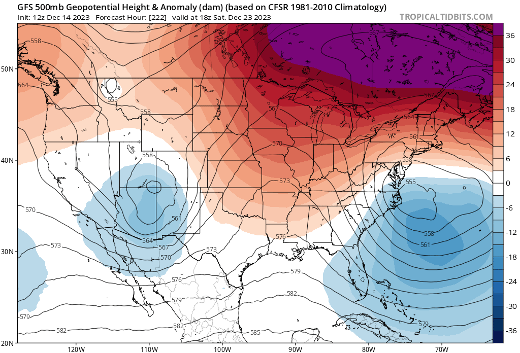
It is first important to note that in that Dec 20-27 period, the entire E US is modeled above-freezing and too warm at most atmospheric layers for snow. However, a strong enough low (sub-990mb) could make its own cold via adiabatic cooling (pressure drop = temp drop) and possibly allow some of that Dec 23 precipitation to fall as snow. The E US upper steering flow will be off the ocean which would drive any oceanic low towards the E US. The possibility would be for a small period of snow before changing to rain. It’s a long shot hope for snow lovers but a low probability. A non-zero chance for something to “thread the needle” in the current pattern.
Otherwise, New Jersey remains in an unfavorable pattern for snowstorm development. We have an active pattern (storm after storm) but we lack the cold air. We’re in an El Nino winter with a progressive/zonal N Pacific jet into the W US. These factors are the culprit for why the rest of December will likely remain unfavorable for New Jersey snow. There are signs of the N Pacific jet relaxing and bunching up into more of a meridional pattern for the US for January. But for now it doesn’t look good until after the New Year.
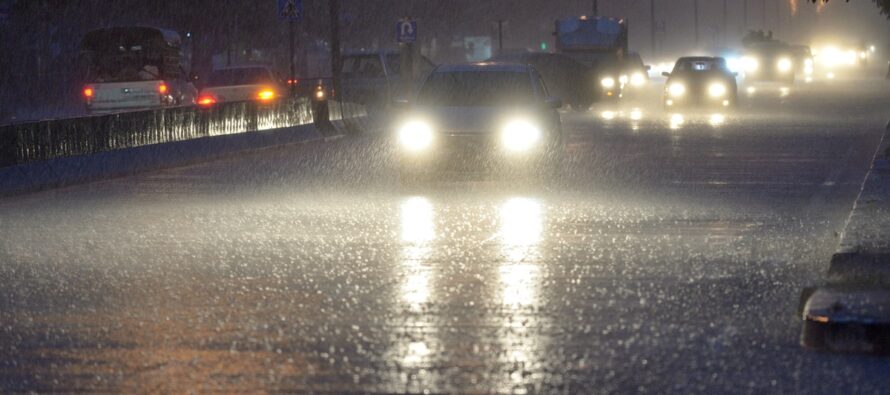
For now, we have to deal with another synoptic storm system in the form of rain and wind. Once our first ridge lifts out, a surface low will ride the front of the approaching transient trough (in the Sunday-Monday window). The low looks to form in the Gulf of Mexico (like a Miller-A) by Saturday and track up the E US coast from Saturday through Monday afternoon. The low should be closest to NJ early Monday morning but will be moving quickly. This should produce the primary weather impacts of rain and wind along with possible secondary impacts of flash flooding, power outages, and coastal flooding. The storm system should crank pretty hard and be most felt for New Jersey from Sunday evening through Monday morning.
In English: The two storm signals I’ve been tracking are very much alive. First is this Sunday-Monday (Dec 17-18) and the other is ~Dec 23-24. The latter is too early to predict much of anything but has a small non-zero chance of wintry precipitation to work in with rain. Let’s get through the more immediate system this Sunday. It is a bit clearer but likely an all-rain event for all of New Jersey. Rainfall should begin by late morning Sunday, peak Sunday evening into early Monday morning, and push out by late-morning on Monday. 1-3 inches of rain are a good bet IMO. Wouldn’t be surprised to see 2-4 inches of rain region wide. For this reason, flash flooding is possible. Winds should become breezy/gusty off the ocean, out of the SE, by Sunday afternoon, then crank Sunday evening into early Monday AM hours. Once the center of the storm passes through NJ, by sunrise Monday morning, winds will first relax for a period and then become just breezy/gusty again but out of the NW. Winds seem manageable away from the ocean for this entire event, but immediate coastal ECNJ/SENJ areas will see the worst of it. For that reason, ECNJ/SENJ have the best chance to see wind-related power outages. Areas away from NJ might be asking “what high winds? It’s just rainy and breezy.” which is common for these types of events. Coastal flooding interests will want to pay attention to the high tides just before noon on Sunday and just before midnight Sunday night. For now it looks like at least minor flooding is possible. Will update accordingly as tidal model data evolves closer to event. I suggest everyone enjoys/leverages the dry and milder conditions Friday and Saturday before the approaching Sunday-Monday rain and wind storm. A small chance of lake-effect flurries Monday night into Tuesday as the system pulls away and pulls colder air back in over the Great Lakes. Hang in there snow lovers! A scoreless first inning but a long ballgame ahead. Be safe! JC
Premium Services
KABOOM Club offers inside info forecast discussion, your questions answered, and early storm impact maps (ahead of the public). At a buck per month, it’s an extremely feasible way to show support.
My Pocket Meteorologist (MPM), in partnership with EPAWA Weather Consulting, offers professional/commercial interests, whose businesses depend on outdoor weather conditions (snow plowing, landscaping, construction, etc.), with hyper-local text message alerts/forecasts and access to the MPM premium forum—the most comprehensive and technical forecast discussion available for PA and NJ.
Get your KABOOM Inside Out pajamas and more at the KABOOM shop!
Jonathan Carr (JC) is the founder and sole operator of Weather NJ, New Jersey’s largest independent weather reporting agency. Since 2010, Jonathan has provided weather safety discussion and forecasting services for New Jersey and surrounding areas through the web and social media. Originally branded as Severe NJ Weather (before 2014), Weather NJ is proud to bring you accurate and responsible forecast discussion ahead of high-stakes weather scenarios that impact this great garden state of ours. All Weather. All New Jersey.™ Be safe! JC


LOCAL FORECAST | INTERACTIVE RADAR | LATEST NJ WEATHER ALERTS | WEDDING FORECAST| PRIVACY POLICY
© Copyright 2026 Weather NJ LLC. All Rights Reserved.
Some information that can be found on our website is provided by a private weather station and is not an officially recognized station for weather reporting. Though we always strive to achieve accurate reporting for our own use, it is important that you do NOT depend on the data provided here for any purpose.
