

Another NNJ Snow Event Detected
Discussion: We’re now close enough to suggest a forecast for Thursday-Friday. We’ve watched this superblock linger near Greenland for a while now. This block will likely be located to the S of Greenland this Thursday-Friday.
A primary surface low will track into the Great Lakes from the W/SW. This low will encounter the block almost head-on and will have nowhere to go. Therefore, it will spawn off a secondary low to the SE, almost like a lateral pass in football. Where this secondary (coastal) low forms is critical to how much snow at least NNJ will see. If the low forms over Viginia/Delmarva and then tracks NE over New Jersey, then most of NJ will see rain again with only NWNJ elevations getting in on the bigger snow. If the low is able to form further out in the ocean and track offshore of New Jersey, then more of NNJ, maybe even CNJ, could get in on the bigger snow.
In either case, there’s a lot of SW flow going on from the primary. This is going to pump warmer air into NJ from the SW. Then the secondary low will have an easterly fetch component to it’s N side which could blow right into NJ. With the ocean still near 50 degrees, this will likely roast out most of the coastal plain. With all of this said, NWNJ has the best chance to see snow and SENJ has the best chance to see rain.
The timing looks like a Thursday afternoon precipitation arrival, peak precipitation Thursday night into Friday, then a taper off either Friday PM or possibly early Saturday morning. Coastal regions could encounter some wind when the low is to the SE of NJ…setting up moderate E winds. But given the short duration of onshore flow, coastal flooding shouldn’t be that bad. Perhaps minor stage flooding at best.
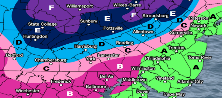
So, areas N of I-80 and NW of I-287 have the best chance to see accumulating/plowable snow. I don’t think we’re talking KABOOM level but likely significant (6+). Lighter snow accumulations could occur as far S as I-78 and as far SE as I-95. Areas S of I-78 and SE of I-95 are likely looking at another rain event like this past weekend. The snow jackpot for this storm is looking like NEPA and maybe some of extreme NWNJ. We think the following snow map is a reasonable expectation:
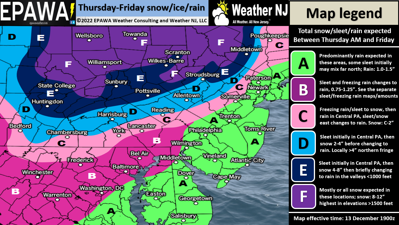
Please click here to see full resolution snow map.
After this clears out, by late Friday night possibly early Saturday AM, the weekend looks pretty cold. At that point, the Dec 11-17 period of transition, surrounding the block behavior, will be in place. I am seeing two more storm signals, likely wintry given the colder setup, between about December 20 and 24. Everyone should prepare for a cold and active pattern right into the new year. The main question, yet to be answered, is will this bring snow SE of 95/NJTP or keep most wintry action to the NW of I-95/NJTP. Regardless, we are now in the first inning of the winter baseball game.
In English: Today should be the last day of colder temperatures. A warmer air mass should then move into CNJ/SNJ for Thursday into Friday keeping most of NJ too warm for snow. Areas N of I-78 and NW of I-95/NJTP, however, will likely remain cold enough for snow Thursday night into Friday before also possibly switching over to rain. Higher NWNJ elevations (N of I-80 and NW of I-287) could see a significant/plowable event from this. Please see our snow map above for accumulation expectations. Have a great rest of your Tuesday and please be safe! JC
Premium Services
KABOOM Club offers inside info forecast discussion, your questions answered, and early storm impact maps (ahead of the public). At 99 cents per month, it’s an extremely feasible way to show support.
My Pocket Meteorologist (MPM), in partnership with EPAWA Weather Consulting, offers professional/commercial interests, whose businesses depend on outdoor weather conditions (snow plowing, landscaping, construction, etc.), with hyper-local text message alerts/forecasts and access to the MPM premium forum—the most comprehensive and technical forecast discussion available for PA and NJ.
Jonathan Carr (JC) is the founder and sole operator of Weather NJ, New Jersey’s largest independent weather reporting agency. Since 2010, Jonathan has provided weather safety discussion and forecasting services for New Jersey and surrounding areas through the web and social media. Originally branded as Severe NJ Weather (before 2014), Weather NJ is proud to bring you accurate and responsible forecast discussion ahead of high-stakes weather scenarios that impact this great garden state of ours. All Weather. All New Jersey.™ Be safe! JC


LOCAL FORECAST | INTERACTIVE RADAR | LATEST NJ WEATHER ALERTS | WEDDING FORECAST| PRIVACY POLICY
© Copyright 2026 Weather NJ LLC. All Rights Reserved.
Some information that can be found on our website is provided by a private weather station and is not an officially recognized station for weather reporting. Though we always strive to achieve accurate reporting for our own use, it is important that you do NOT depend on the data provided here for any purpose.
