

Another Snowstorm Detected
Discussion: I’ve taken the KABOOM profile pic (white circle) down, For many new faces, KABOOM is the term I like to use when 12 inches of snow happen in any part of NJ. Sometimes it’s confined to either NNJ, CNJ, or SNJ. Sometimes it affects the entire state. Either way, all of us snow fans (myself included), get real excited about it. I’ve seen some great memes out there in the comments before. It all began sometime around the Winter 2013-2014 Polar Vortex outbreak.
But anyway, I’ve left up the snowstorm banner pic because the chances of another NJ snowstorm this Thursday night into Friday are increasing. This is aligned with the general storm signal we’ve been mentioning.
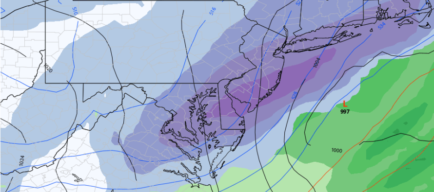
There’s pretty tight agreement in NJ getting hit one way or another but still some uncertainty as to the jackpot axis of snowfall. Last week the signal jackpot was favoring areas NW of I-95 (EPA into NNJ). Models have recently trended towards either a statewide general hit of 3-6/4-8 inches or a CNJ/SNJ jackpot (3-6/4-8) with EPA and NNJ on the lower amount NW side (see above GFS image – snowiest 6-hour impact). We’re only 48 hours out so confidence it rapidly building. The shorter-range NAM and RGEM models are agreeing.
We have developing dynamics but lack blocking to slow the low down. We also have a flat ridge in the W US, not a steep one. Otherwise, the models would have a lot more snowfall than a consensual 3-6/4-8. But who knows, there’s still some wiggle room for a slightly stronger surface low which could at least tap the breaks some. To be clear that’s not showing now/yet and will obviously become a discussion point if that data trends that way. For now, a quick mover through NJ between about Midnight and Noon of Friday with expected amounts still a little too soon to generate. There is uncertainty as to whether it will be considered significant or major.
In English: Chances of another snowstorm impacting NJ are increasing this Friday morning. It could begin late Thursday night and wrap up around noon on Friday. At this point I am only willing to suggest at least plowable accumulations either statewide or possibly just CNJ/SNJ (like the above GFS image shows). By tomorrow we should be able to narrow that down a bit. But the overall trend has been S (from NNJ only to CNJ/SNJ) with the heaviest expected snowfall. Let’s see what another 24 hours of data brings us. I’ll put the KABOOM profile pic back if it starts to look like 12 inches anywhere in NJ. Otherwise the snow storm banner will remain up with Friday’s current expectations. Be safe! JC
Download the free Weather NJ mobile app on Apple or Android. It’s the easiest way to never miss Weather NJ content. Our premium services go even further above and beyond at the hyper-local level.
Jonathan Carr (JC) is the founder and sole operator of Weather NJ, New Jersey’s largest independent weather reporting agency. Since 2010, Jonathan has provided weather safety discussion and forecasting services for New Jersey and surrounding areas through the web and social media. Originally branded as Severe NJ Weather (before 2014), Weather NJ is proud to bring you accurate and responsible forecast discussion ahead of high-stakes weather scenarios that impact this great garden state of ours. All Weather. All New Jersey.™ Be safe! JC


LOCAL FORECAST | INTERACTIVE RADAR | LATEST NJ WEATHER ALERTS | WEDDING FORECAST| PRIVACY POLICY
© Copyright 2026 Weather NJ LLC. All Rights Reserved.
Some information that can be found on our website is provided by a private weather station and is not an officially recognized station for weather reporting. Though we always strive to achieve accurate reporting for our own use, it is important that you do NOT depend on the data provided here for any purpose.
