

Another Stormy Humid Night
Discussion: I’m thinking “Relentless Stormy Humidity” was a good title for this week’s weekly outlook. Last night’s (Tuesday night) storms produced most violently in WCNJ/SWNJ before fizzling a bit for the coast. NNJ saw less intense action. A few tornado warnings in CNJ but so far none have been confirmed by the NWS. Onto today (Wednesday)…
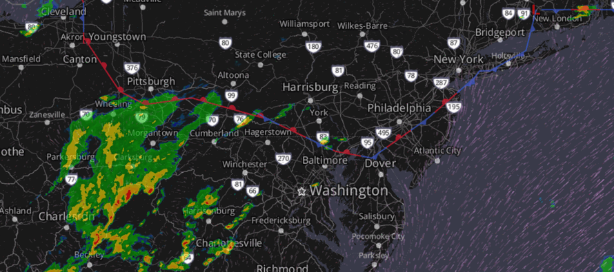
Today is another humid and stormy day (eventually). If you look at the main graphic of this post, you can see a stationary boundary (the best lifting) running through SNJ/CNJ almost parallel to the I-95/NJTP corridor. You can also see the rain and thunderstorm development approaching/moving through SWPA, W MD, and W VA. This represents the storm energy that will push across NJ later today/tonight and become enhanced by the lifting of the stationary boundary. Much like yesterday (Tuesday), today (Wednesday) features adequate diurnal destabilization (instability), wind shear, and the lifting trigger (boundary) to produce another stormy night.
Given the profile of dynamics, tonight should target the west side of CNJ/SNJ again with the heaviest and most intense thunderstorms. I’m thinking I-195 should separate the weaker rain/rumbles to the N from the more severe potential to the S. I-195 pretty much cuts right across NJ from W to E, dividing NJ in half. That puts all of SNJ and much of CNJ on the hook for tonight’s thunderstorm action.
Timing is rather straightforward for the main event tonight, which is a linear stormfront that arrives for WNJ around 9pm, pushes across NJ from 9pm-midnight, and departs ENJ with any remnant showers/storms by about 2-3am. There could be a few cells that spin up ahead of the main event stormfront though…anytime from now until the stormfront arrives.
In English: Expect another stormy night in NJ tonight (Wednesday night). A few isolated showers and thunderstorms are possible this afternoon-early evening but the main event stormfront should push through from about 9pm-1am later tonight. The most severe storms of tonight should occur S of I-195 with SWNJ targeted for ground zero. As always, weakening is very possible by the time the WCNJ/SWNJ action makes it to ECNJ/SENJ due to marine influence and loss of sunlight. Areas N of I-195 are on the hook for showers and rumbles but the best storm dynamics are in SNJ and the southern half of CNJ (S of I-195). As always, rain and rumbles are a safe expectation with isolated instances of damaging winds, flash-flooding downpours, and frequent lightning. The rest of the week looks to continue the relentless stormy humidity though Thursday looks the least rainy/stormy. Have a great night and be safe! JC
Premium Services
KABOOM Club offers ad-free content, inside info forecast discussion, your questions answered, and early storm impact maps and video releases (ahead of the public). At $1.99 per month, it’s an extremely feasible way to show additional support for Weather NJ and you can can turn it on and off for however many months you wish. Think of it as a tip jar with perks. The public eventually sees all info discussed in premium areas. Available onFacebook or Patreon.
My Pocket Meteorologist (MPM), in partnership with EPAWA Weather Consulting, offers professional/commercial interests, whose businesses depend on outdoor weather conditions (snow plowing, landscaping, construction, etc.), with hyper-local text message alerts/forecasts and access to the MPM premium forum—the most comprehensive and technical forecast discussion available for PA and NJ.
Jonathan Carr (JC) is the founder and sole operator of Weather NJ, New Jersey’s largest independent weather reporting agency. Since 2010, Jonathan has provided weather safety discussion and forecasting services for New Jersey and surrounding areas through the web and social media. Originally branded as Severe NJ Weather (before 2014), Weather NJ is proud to bring you accurate and responsible forecast discussion ahead of high-stakes weather scenarios that impact this great garden state of ours. All Weather. All New Jersey.™ Be safe! JC


LOCAL FORECAST | INTERACTIVE RADAR | LATEST NJ WEATHER ALERTS | WEDDING FORECAST| PRIVACY POLICY
© Copyright 2025 Weather NJ LLC. All Rights Reserved.
Some information that can be found on our website is provided by a private weather station and is not an officially recognized station for weather reporting. Though we always strive to achieve accurate reporting for our own use, it is important that you do NOT depend on the data provided here for any purpose.
