

Another System Approaching NJ. Snow Graze for NNJ
Discussion: Just a few small adaptations on today’s impact map. Let’s just walk through it in phases.
Our break in the rain will end tonight (Saturday) around midnight as more rain moves into the region from the W and spreads into all of NJ by about 2-3am. Rain should continue to fall statewide but between about 6-10am tomorrow (Sunday), extreme NNJ should start to change over from rain to a wintry precipitation type. Might be snow, might be a little sleet mixed in, but it will likely not be a pure snow dumping that immediately stacks. The ground will still be warm but gradually cooling below freezing. Places like High Point in Sussex County have the best chance to see accumulating snow. However, we are allowing lighter accumulations down to I-80 or just N of such. This slug of precipitation should come to an end by noon Sunday. SNJ has a better chance to see a break in the rain than NNJ between about noon Sunday and later Sunday evening. There could be some spotty drizzle remaining around.
At this point the primary low will have tracked near the SW corner of PA and will be transferring to a secondary coastal low somewhere near Delmarva. This is classic Miller-B transfer. The precipitation associated with the primary low will sail off (around noon Sunday) and there will be a lull while we wait for the new secondary coastal low to take over. Once this happens, then colder air will be pulled down from Canada and any remnants rain could change to snow for more of New Jersey. This would likely start happening around midnight or just before Sunday night and would last through mid-to-late Monday morning. The problem is that surface temperatures will be a few degrees above freezing for most of NJ S of I-80. So an unlikely snow accumulation situation but could certainly produce conversational snow that struggles to stick anywhere other than on grassy surfaces.
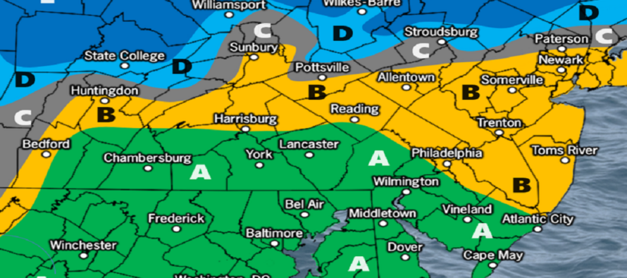
Earlier this week, there was high pressure modeled in SE Canada to meet the storm low directly below it. This 1) would have prevented the storm from tracking so far N and 2) would have created a direct highway for the extremely cold Arctic air in E Canada to spill into the storm anti-cyclonically. In the last 3 days or so, the trend has been for this high pressure to be weaker and slower, allowing the storm to track slightly N and less cold. So what looked like a thread-the-needle hit has become a mistimed graze. Here’s is our final impact map heading into the tonight.
After this system clears out Monday, hopefully after a conversational snowy morning for some, the next long-range signal I’m tracking is Feb 3-5. Models are struggling to handle this time frame and are wildly erratic. It would still be considered thread the needle compared to the favorable pattern setting up later in February. But it’s the next thing to watch as the general pattern looks to start doing the exact opposite of what December did. February is looking wintry and wild though. I will revisit it all once this system is through on Monday.
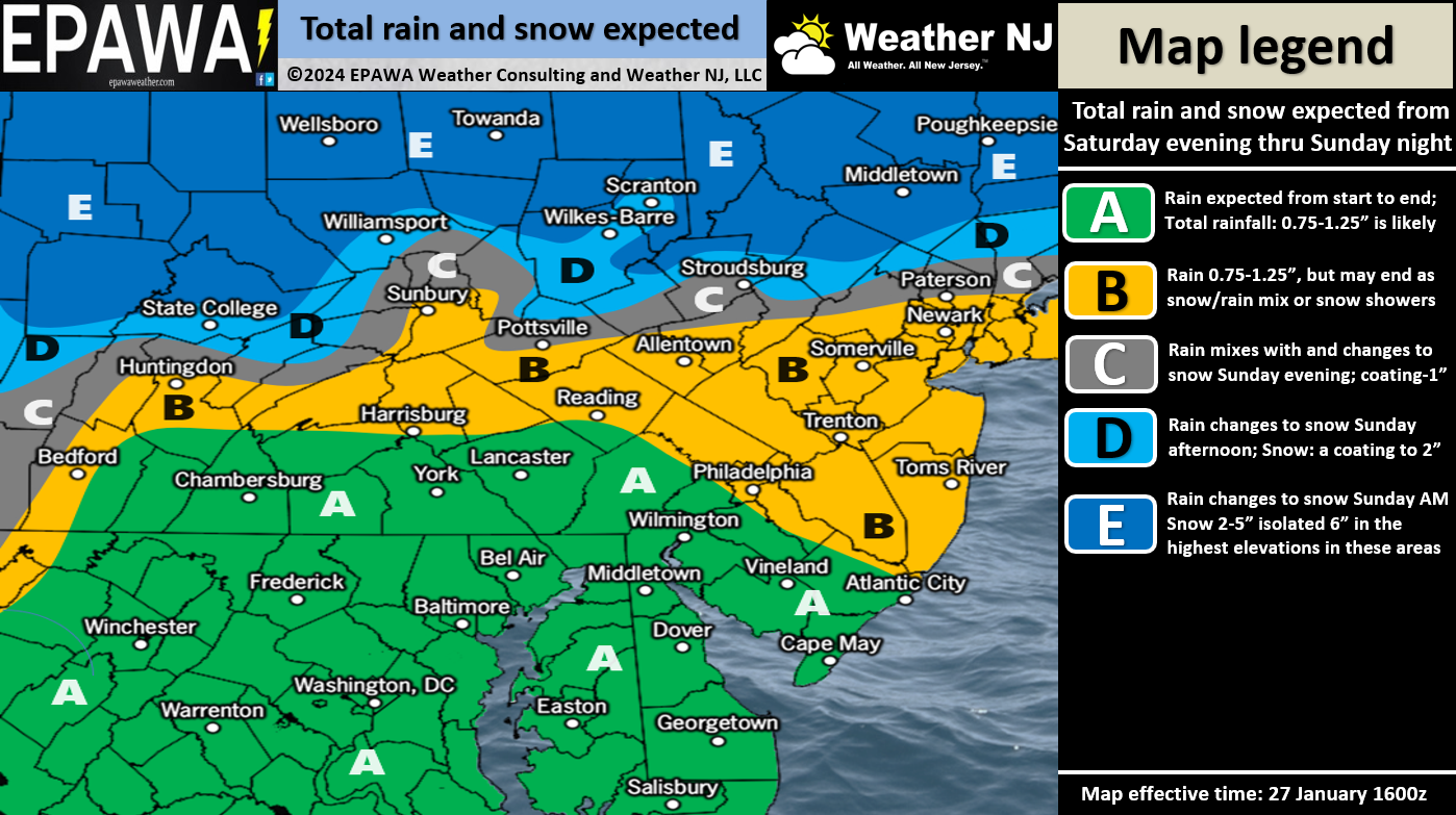
In English: Rain will move back in overnight tonight and fall through most of Sunday into Monday morning. NNJ could see a changeover from rain to wintry precip between tomorrow morning and about noon tomorrow. All areas along and S of I-80 should stay rain tonight and most of tomorrow. Precip then relaxes and comes back Sunday night into Monday morning, possibly as non-accumulating snow for more than just “I-80 and N” …the backside of the coastal low. It could be pretty in the air, especially for ENJ, but it will likely struggle to accumulate with surface temperatures just above freezing despite aloft temperatures cold enough to at least support making snow. This is why we’ve expanded zone B a little further S into NJ. Just a small wildcard to watch. Otherwise we all dry out and Monday gradually improves through afternoon hours. Watching February for a much more favorable snowstorm pattern. Will revisit on Monday. For now, live observations will begin with the first drops tonight. Have a great rest of your Saturday and please be safe! JC
Premium Services
KABOOM Club offers inside info forecast discussion, your questions answered, and early storm impact maps (ahead of the public). At a buck per month, it’s an extremely feasible way to show support.
My Pocket Meteorologist (MPM), in partnership with EPAWA Weather Consulting, offers professional/commercial interests, whose businesses depend on outdoor weather conditions (snow plowing, landscaping, construction, etc.), with hyper-local text message alerts/forecasts and access to the MPM premium forum—the most comprehensive and technical forecast discussion available for PA and NJ.
Get your KABOOM Inside Out pajamas and more at the KABOOM shop!
Jonathan Carr (JC) is the founder and sole operator of Weather NJ, New Jersey’s largest independent weather reporting agency. Since 2010, Jonathan has provided weather safety discussion and forecasting services for New Jersey and surrounding areas through the web and social media. Originally branded as Severe NJ Weather (before 2014), Weather NJ is proud to bring you accurate and responsible forecast discussion ahead of high-stakes weather scenarios that impact this great garden state of ours. All Weather. All New Jersey.™ Be safe! JC


LOCAL FORECAST | INTERACTIVE RADAR | LATEST NJ WEATHER ALERTS | WEDDING FORECAST| PRIVACY POLICY
© Copyright 2026 Weather NJ LLC. All Rights Reserved.
Some information that can be found on our website is provided by a private weather station and is not an officially recognized station for weather reporting. Though we always strive to achieve accurate reporting for our own use, it is important that you do NOT depend on the data provided here for any purpose.
