

Another Winter Storm Possible
Discussion: Model data has been persistent on a ~Valentine’s Day winter storm signal since this past Saturday, Feb 5. The signal has ghosted in and out of day 5-9 long-range model guidance but here we are today 4 days out with a building consensus of at least a light snow event, possibly greater.
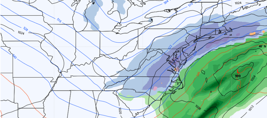
It will be hard to think that snow is possible this Sunday, especially as NJ builds into the 50s, possibly 60 by Saturday afternoon. But the Arctic frontal boundary will only retreat so far N before coming back down. And we know that air is still cold. This Sunday-Monday system looks to tap that Arctic air mass and inject the subtropical jet full of moisture. The surface low, however, is modeled weak. So that’s what we have…a weak modeled low with a super cold Arctic tap and super moist subtropical tap. That’s why snow returns have higher potential with basically only a 1000+mb low. If this low drops into the 990s then major snow will be likely. But right now (on model consensus) it starts around 1006mb and maybe reaches 999mb before pulling away from our region.
There are a few complex moving parts in the upper levels. Two N stream vorts are expected to come in separated by a closing ridge. That ridge then closes and unites the two N vorts into a single N vort. It’s not a phase because it’s from the same stream. The S stream then wraps in and turns the upper-level steering currents NW over the coast which brings the low up the coast but offshore. That’s why areas along and SE of 95 are currently targeted on the GFS (above image). Like many of the systems this year, SENJ, might stay hot at the snow table. You need to see more interaction upstream to turn this any more to the NW. Completely possible but current scientific data is not showing that. The Canadian was pretty N but had a strange upper-level look to the N stream. Most other guidance is more unanimous on the GFS/Euro idea. Ensemble guidance has most members either centered over the mean low or just NW. A sign that the signal will probably hold IMO. It’s a little too soon to get excited or bent over daily deterministic output.
At this point I am still processing model data, run-by-run and suite by suite. However tomorrow we will be three days out and it will be time to start preparing for another possible snowstorm for at least areas SE of 95. That’s if the current look holds or even tightens (becomes more certain). But let’s leave ourselves an out since we are still at day four with a solid amount of uncertainty. That’s why I’m using the word possible and not yet detected or approaching.
As far as timing goes, the trend has been forward towards more of a Sunday late-morning, through Sunday PM, and into Monday early AM kind of thing. It’s no longer a Valentine’s Day only potential system. It might only spill into the early AM hours of Monday with clearing possible by daybreak Monday morning.
In English: Milder conditions should continue to build between now and Saturday afternoon. Temperatures should then take a solid drop Saturday night into Sunday morning with snow possible Sunday into Monday (late-Sunday morning through early Monday morning). We have some room for trending and changes but it’s starting to look like another SENJ (SE of 95) jackpot for whatever does happen (lighter event or stronger snowstorm). We should know a lot more 24 hours from now (for tomorrow’s update). But another winter storm remains possible this Sunday-Monday.
Jonathan Carr (JC) is the founder and sole operator of Weather NJ, New Jersey’s largest independent weather reporting agency. Since 2010, Jonathan has provided weather safety discussion and forecasting services for New Jersey and surrounding areas through the web and social media. Originally branded as Severe NJ Weather (before 2014), Weather NJ is proud to bring you accurate and responsible forecast discussion ahead of high-stakes weather scenarios that impact this great garden state of ours. All Weather. All New Jersey.™ Be safe! JC


LOCAL FORECAST | INTERACTIVE RADAR | LATEST NJ WEATHER ALERTS | WEDDING FORECAST| PRIVACY POLICY
© Copyright 2026 Weather NJ LLC. All Rights Reserved.
Some information that can be found on our website is provided by a private weather station and is not an officially recognized station for weather reporting. Though we always strive to achieve accurate reporting for our own use, it is important that you do NOT depend on the data provided here for any purpose.
