

April 17: More Severe Weather Possible
Discussion: I’m watching Friday night through Saturday morning for another period of potential severe weather (like this past early-Monday morning).
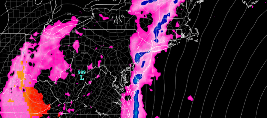
The first player involved is a low pressure system currently cutting way to our NW over the N Great Lakes. This will bring an initial warm front through overnight tonight into tomorrow (Thursday). This will allow warmer humid air mass to flow into New Jersey from the SW for Thursday and Friday. The initial low then races off as another low approaches closer to our region but still to our NW. This second low will interact with a strong cut-off Upper-Level Low (ULL) floating through the E US. Here lies the interesting dynamics.
The ULL will assist formation of a negative tilt to the overall jet flow. This will create an area of pressure drops fed by Positive Vorticity Advection (PVA) spreading out the air aloft. The negatively-tilting ULL axis should produce SE flow aloft over S/SW flow at the surface. Therefore there will be vertical wind shear (change in wind direction at different altitudes) which is a critical component to severe weather.
Friday will be very mild with a humid feel. Therefore surface heating should destabilize the region especially from noon through sunset. If the thunderstorm line arrives earlier Friday PM then the instability will feed in with the shear and likely produce a more severe outcome. If the thunderstorm line is late then it will not capitalize on Friday’s peak diurnal heating. Instead it will move through overnight (early Saturday morning) and mostly be powered by wind shear. So earlier Friday PM = more severe potential. Later Saturday AM = less severe potential. I hope to narrow this uncertainty down by Friday morning. Either way the Friday PM through Saturday morning period in general looks stormy.
The ULL should enhance rainfall just behind the frontal passage and keep the weekend very unsettled before clearing out Sunday PM.
In English: Heavy rain, gusty winds, strong-to-severe thunderstorms, hail and more tornadoes are possible this Friday evening into Saturday morning (April 19-20) across the region. This includes Delaware, NJ and E PA. Timing is still uncertain but basically the storms will feature higher winds and more frequent lightning if they arrive closer to sunset Friday night. If they arrive later overnight (early Saturday AM) then we would be looking at more of a widespread heavy rain threat with only embedded thunderstorms. While severe criteria would still be possible with the latter it would not be as bad as the former. This is an initial assessment which will be tuned finer by tomorrow evening or Friday morning. I’ll have the weekend outlook posted tomorrow evening, separate of any additional severe weather articles. Have a great night and please be safe! JC
Download the new free Weather NJ mobile app on Apple and/or Android. It’s the easiest way to never miss Weather NJ content. Our premium services go even further above and beyond at the hyperlocal level. Looking for industrial-caliber long-range forecasting data that I personally recommend? Check out WeatherTrends360!
Jonathan Carr (JC) is the founder and sole operator of Weather NJ, New Jersey’s largest independent weather reporting agency. Since 2010, Jonathan has provided weather safety discussion and forecasting services for New Jersey and surrounding areas through the web and social media. Originally branded as Severe NJ Weather (before 2014), Weather NJ is proud to bring you accurate and responsible forecast discussion ahead of high-stakes weather scenarios that impact this great garden state of ours. All Weather. All New Jersey.™ Be safe! JC


LOCAL FORECAST | INTERACTIVE RADAR | LATEST NJ WEATHER ALERTS | WEDDING FORECAST| PRIVACY POLICY
© Copyright 2026 Weather NJ LLC. All Rights Reserved.
Some information that can be found on our website is provided by a private weather station and is not an officially recognized station for weather reporting. Though we always strive to achieve accurate reporting for our own use, it is important that you do NOT depend on the data provided here for any purpose.
