

April 2: Coastal Storm to Graze NJ
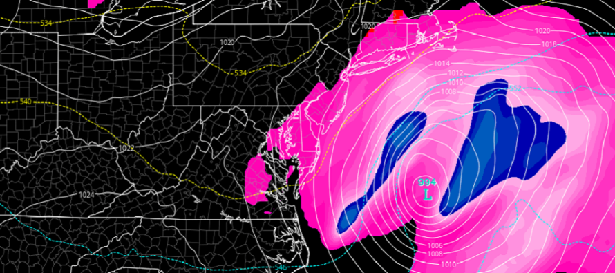
Discussion: A negative-tilted trough will swing through the E US tonight through tomorrow. Two shortwaves are involved. The northern energy is slower and behind the southern energy and therefore we do not have a favorable phase for high impact in the Mid-Atlantic US. Instead the slow phase results in unorganized upper-level vorticity slipping the coastal storm E of where it would need to be.
The coastal storm should pass about 300-400 miles offshore of NJ from SW to NE from now through tomorrow morning. Fringe-impact rain and wind are possible but nothing to panic about. We’re talking about a quarter-inch of rain for the ENJ/SENJ coasts with lesser amounts expected away from the ocean. I doubt rain will even reach as far W as the Delaware River. We’re also talking about overnight rainfall tonight with little impact to daylight hours today or tomorrow. Most rainfall should clear to the NE by sunrise tomorrow morning.
Wind activity should be confined to the coast as well. Most of NJ away from the ocean will be wondering “what wind” while the immediate coast sees a period of onshore flow this evening, N flow overnight and NW flow tomorrow morning. This wind direction will rock cyclonically with the passing low.
With such a progressive system there is only one high tide of concern for coastal flooding which occurs mid-tomorrow morning. As of right now minor coastal flooding is the most realistic outcome with a small chance of reaching into moderate territory. If this was a longer-duration nor’easter then coastal flooding would be a higher concern.
It all moves out tomorrow morning and then we moderate towards sustained warmer temperatures for the weekend and next week.
In English: This is not a nor’easter IMO. There is no stall due to blocking nor retrograde in storm track into the coast. It’s a coastal storm. Will there be a short period of NE winds yes. Will there be days of it? No. With that said a coastal storm should pass close by ENJ/SENJ tonight. It will be ugly out in the ocean but not too bad for us. Immediate coastal regions are favored for the highest impacts which are pretty meh in terms of a rain and wind storm. Up to a quarter-inch of rain, winds of 20-30mph and minor coastal flooding are the most reasonably-expected outcomes for the ENJ/SENJ coast. Areas away from the ocean should see very minor impacts if any at all. We’ve seen stronger. Everyone have a great night and please be safe! JC
Download the new free Weather NJ mobile app on Apple and/or Android. It’s the easiest way to never miss Weather NJ content. Our premium services go even further above and beyond at the hyperlocal level. Looking for industrial-caliber long-range forecasting data that I personally recommend? Check out WeatherTrends360!
Jonathan Carr (JC) is the founder and sole operator of Weather NJ, New Jersey’s largest independent weather reporting agency. Since 2010, Jonathan has provided weather safety discussion and forecasting services for New Jersey and surrounding areas through the web and social media. Originally branded as Severe NJ Weather (before 2014), Weather NJ is proud to bring you accurate and responsible forecast discussion ahead of high-stakes weather scenarios that impact this great garden state of ours. All Weather. All New Jersey.™ Be safe! JC


LOCAL FORECAST | INTERACTIVE RADAR | LATEST NJ WEATHER ALERTS | WEDDING FORECAST| PRIVACY POLICY
© Copyright 2026 Weather NJ LLC. All Rights Reserved.
Some information that can be found on our website is provided by a private weather station and is not an officially recognized station for weather reporting. Though we always strive to achieve accurate reporting for our own use, it is important that you do NOT depend on the data provided here for any purpose.
