

April 2017 Discussion

It’s time to harness the WeatherTrends360 proprietary weather algorithms to see how the rest of April 2017 should play out. But first lets break New Jersey into proper climatological regions. We have the higher elevations of NNJ/NWNJ, the interior coastal plain (SWNJ through CNJ and into NENJ), and the coastal regions (most of SENJ). I’ll be representing each climatological region with a 28-day graph from weathertrends360 data followed by a brief discussion.
Please keep in mind that these algorithms are documented with an 84% verification rate and are based on oceanic water cycles, time table series and very complex mathematics. The best takeaway from this data are general trends (cool vs warm, rainy vs dry, etc). I’m always hesitant to forecast specific surface conditions (rainfall amounts, snowfall amounts, winds, etc) beyond the 4-7 day forecasting period. But temperature and precipitation trends is what WeatherTrends360 does best with their proprietary mathematical analysis derived from over 150 years of reactive pattern data. For this reason, let’s call this a long-range discussion of expectations rather than a locked-in forecast.
Higher Elevations of NNJ/NWNJ
(Sussex, Warren, Hunterdon, Morris, N. Somerset, and N. Passaic) – Known for little to no Atlantic Ocean influence, colder-snowier winters, and drier conditions in general when compared to the coast. This region is known to get hot when high pressure sits overhead during the summer and bitterly cold during Arctic outbreaks in the winter. Elevation is a major influence that separates this micro-climate from the rest of New Jersey. This region extends into NE PA (Poconos) and parts of NY State (Catskills).
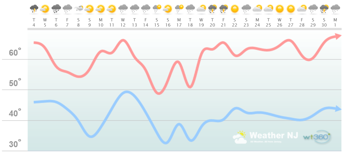
Higher Elevation Discussion: This region is looking fairly mild with daytime high temperatures averaging in the upper-50s/lower-60s. Overnight temperatures however should produce many frosts and potentially a few freezes this month as we approach the agricultural and gardening season. Precipitation should continue to be plentiful as more synoptic rainfall systems are anticipated. I expect this active pattern to continue through most of April which should put a solid hurting on the drought situation by months-end. This is indicated on the graphic above and most long-range model guidance agrees. While April flurries and snow showers are possible in the highest elevations of NWNJ, even this region is pretty much finished with snow storms.
Interior Coastal Plain from SWNJ-CNJ-NENJ
(Salem, Gloucester, Camden, W. Burlington, Mercer, W. Monmouth, Middlesex, S. Somerset, Union, Essex, Hudson, Bergen, and S. Passaic) – Known for naturally higher temperatures due to lower elevations away from the oceanic influence. This region is also known as “heat island” due to transportation (I-95 corridor), smog, abundant asphalt, concrete, and other man-made substances that naturally absorb and retain heat moreso than natural protected land. This is why excessive heat warnings and air quality alerts are more common in this region. SWNJ always tends to run a few degrees warmer than NENJ but this region is very similar otherwise in micro-climate due to the parallel nature of the Appalachian Mountain elevations to the NW. The same micro-climate can be extended into SE PA and NE MD which tends to run just a little stormier than NJ. This however is what makes up the interior coastal plain.
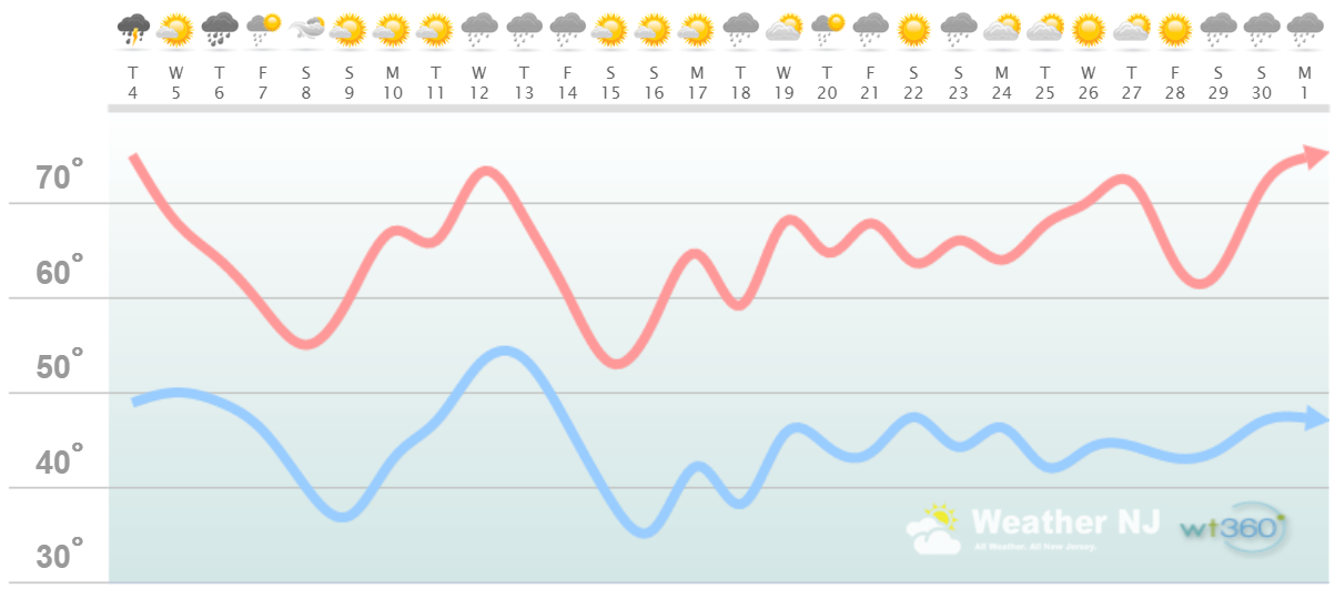
Interior Coastal Plain Discussion: This region is looking mild with daytime high temperatures averaging in the 60s with a few 70s here and there. Overnight temperatures however are capable of producing frosts but according to the data, might be finished with freezes. Precipitation should continue to be plentiful as more synoptic rainfall systems are anticipated. I expect this active pattern to continue through most of April which should put a solid hurting on the drought situation by months-end. This is indicated on the graphic above and most long-range model guidance agrees. This region is likely finished with snow storms and maybe even snow showers/flurries.
Coastal Regions of SENJ
(Cumberland, Cape May, Atlantic, E. Burlington, Ocean, and E. Monmouth) – Known for tremendous influence from the Atlantic Ocean. Oceanic influence keeps this zone cooler in the summer and warmer in the winter than the interior coastal plain and especially the higher elevations of NWNJ. In the summer, sea breeze fronts back into the coast and can ignite thunderstorms if enough instability is present. The cooler marine air slides under the hot air to the W and provides additional atmospheric lifting. This is both why it’s 5-15 degrees cooler at the shore than the Philly-Trenton area and why near-stationary thunderstorms can form along the coast capable of producing localized flash flooding. In the winter, the ocean is warmer than interior regions which plays a huge role in rain vs. snow—highly dependent on wind direction. When the winds chance from NE to N/NE, that’s usually when temps crash and change rain over to snow. Regardless, this micro-climate is well known, well documented and well expressed. This region extends into most of Delaware as well.
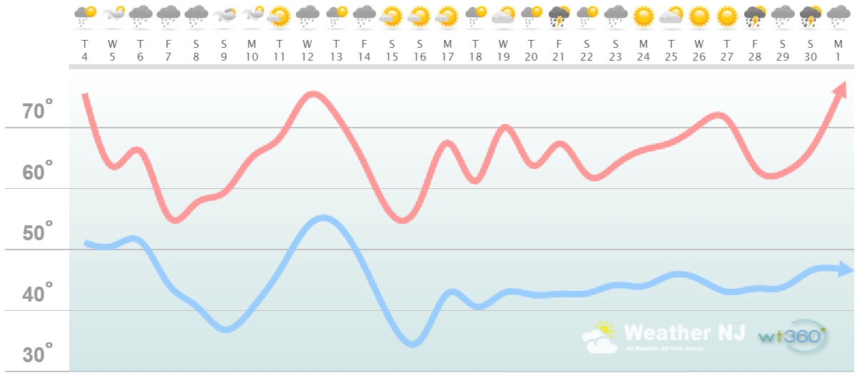
Coastal Region Discussion: This region is looking fairly mild with daytime high temperatures averaging in the 60s. Overnight temperatures however are capable of producing a few frosts during the first 2/3 of April. It’s always a safe bet to wait for Mothers Day to plant in this region but we might be home-free a bit earlier this year. Keep in mind that ocean temperatures are still in the lower-40s. Therefore any kind of onshore flow (light or strong) can drop temperatures substantially even on a super nice day. Until the ocean warms into the 60s or above, which isn’t typically until June, chill-out episodes remain possible along the immediate coast. Precipitation should continue to be plentiful as more synoptic rainfall systems are anticipated. I expect this active pattern to continue through most of April which should put a solid hurting on the drought situation by months-end. This is indicated on the graphic above and most long-range model guidance agrees. This region is finished with snow until later this year.

Weathertrends360 is a complete, global, web solution to help retailers and suppliers capitalize on the weather and its influence on sales and marketing plans up to a year ahead. Learn how to become PROACTIVE vs REACTIVE with the weather in every phase of your business – how much inventory to buy/produce, where to allocate more/less, when to run weather-optimized advertising/marketing campaigns – weathertrends360 can help you determine all of this in minutes! 84% independently audited accuracy for both short-term and year-ahead forecasts for temperature and precipitation.
In English: Overall, the month of April looks to feature above-average temperatures and above-average precipitation for New Jersey. So mild and wet, possibly stormy. That’s not to say that there won’t be beautiful sunny days between the active pattern of low pressure systems. This should jumpstart lawns, vegitation and any trees that haven’t already flowered by months-end. The elevations of NWNJ could still see a few freezes while immediate coastal areas are subject to colder marine influence. For this reason, interior CNJ and SNJ have the best chance of spiking daytime high temperatures north of 70 degrees. Summer is coming Jersey, and always sooner than you realize! Let’s sit back and enjoy some much-needed spring transition in the meantime. Have a great month of April and please be safe! JC
Jonathan Carr (JC) is the founder and sole operator of Weather NJ, New Jersey’s largest independent weather reporting agency. Since 2010, Jonathan has provided weather safety discussion and forecasting services for New Jersey and surrounding areas through the web and social media. Originally branded as Severe NJ Weather (before 2014), Weather NJ is proud to bring you accurate and responsible forecast discussion ahead of high-stakes weather scenarios that impact this great garden state of ours. All Weather. All New Jersey.™ Be safe! JC


LOCAL FORECAST | INTERACTIVE RADAR | LATEST NJ WEATHER ALERTS | WEDDING FORECAST| PRIVACY POLICY
© Copyright 2026 Weather NJ LLC. All Rights Reserved.
Some information that can be found on our website is provided by a private weather station and is not an officially recognized station for weather reporting. Though we always strive to achieve accurate reporting for our own use, it is important that you do NOT depend on the data provided here for any purpose.
